………“It is important to emphasize that we are not in a simplistic analysis, but rather at a crossroads of complexities. We have to combine making it until the end of the month with the end of the world.”
Nicolas Hulot
Journalist, environmental activist and former ecology minister of France
Interview in El País
As a consequence of its geography and climate, Chile has some of the best places for the installation of renewable energy production infrastructures in the world. From the driest desert with the highest solar radiation in the north, to the flow and power of rivers born in the Andes meandering down to the central valleys, and the glaciers and the tides of the Strait of Magellan at the southern tip of the continent.
Both due to these exceptional natural conditions and due to a series of changes in the industry (local and global), this transformation has become irreversible. Framed by strong social movements demanding a more ecological perspective between infrastructures and territory, the construction of renewable energy projects is taking place at a speed that forces us to urgently rethink this transformation and its possible impacts, consequences, and potentialities.
In this context, the research starts by asking about the impacts, problems, and above all, the opportunities of the different types of renewable energy projects (solar, wind, geothermal, hydroelectric, tidal, hydrogen, etc.) that are being implemented today and during the next decade. Along more than 4,000 km, in a range of latitudes equivalent to the distance between Norway and Egypt, different communities in different geographies and climates will be affected by these new infrastructures.
We set ourselves the challenge of interpreting them as public assets, to rethink their historical condition of black boxes, isolated, mono-functional, and negative externalities, taking advantage of the fact that, in many cases, these are the most important investments that these places will receive in a long time. If we understand that these artifacts are part of a larger system of productive flows that organizes the global territory, it seems imperative to assume not only their functional importance, but also their symbolic importance and their potential to shape new collective spaces.

The research consists of projects at different scales, ranging from the territorial to the architectural, that propose alternative ways of designing and integrating these infrastructures into their contexts, surpassing the current approach based mainly on technical and economic variables, associating the potential sources of energy generation with the various regions and latitudes of the country, together with their geographical, ecological, productive, and cultural specificities.
The development of the territory is understood today as a competition for land and its resources between producers, on the one hand, and local communities and ecosystems on the other – the latter being always the most disadvantaged. The mere production of renewable energies, as an isolated endeavor, is not sufficient in the transition to a post-carbon world. However, and in any case, it is a necessary condition as a starting point.
We have imagined new forms of mediation and coexistence that are more complex and just, as a phrase widely spread on the internet says: “If it deprives the people, it is not clean energy.”
Here is a selection of five projects out of a total of more than 25 developed throughout Chile’s territory between 2016 and 2021.
Solar Colonization
Multi-industrial Connection of the María Elena Settlement
Location: María Elena, Region of Antofagasta, Norte Grande, Chile
_ Jose Luis Reyes
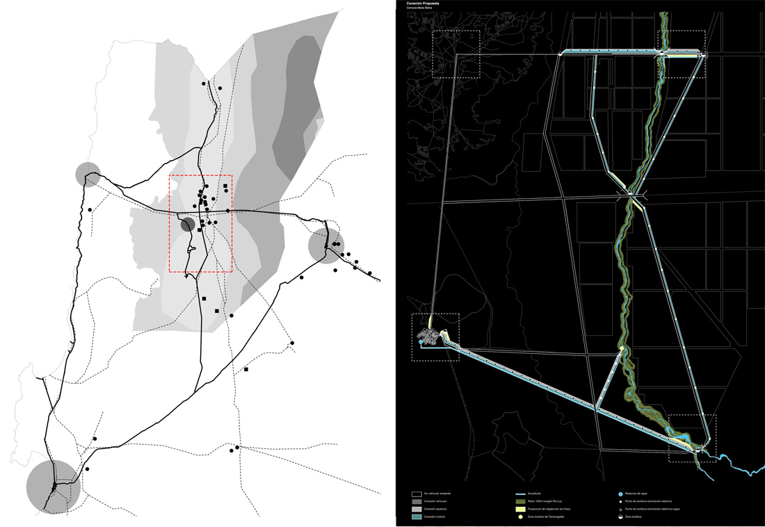
The occupation of the Chilean desert has historically been developed under the auspices of mining industries such as saltpeter, nitrates, copper, and, more recently, lithium. The desert has been the place where the settlements created by and for the industry have evolved, moving from the construction of complete cities to camps, and more recently, to mining hotels.
Recently, a new actor has emerged and is progressively colonizing the desert on an even faster and larger scale than the previous ones: the production of solar energy.
In the surroundings of the María Elena settlement – the last inhabited company town in the world – the largest number and concentration of solar plants in Chile are being built and projected due to the radiation conditions and topography. This development presents the possibility of rethinking and taking advantage of the already existing infrastructures that are obsolescent and being dismantled, making it possible to test new models of territorial design and circular production that can accommodate the current and future needs of the region, both in terms of industry and the inhabitants and the existing ecosystem.

Altoandino Meteorological Park
Catalyst of atmospheric experiences in a geothermal plant
Location: Juncalito River, Atacama Region, Norte Chico, Chile
_Constanza Bianchini
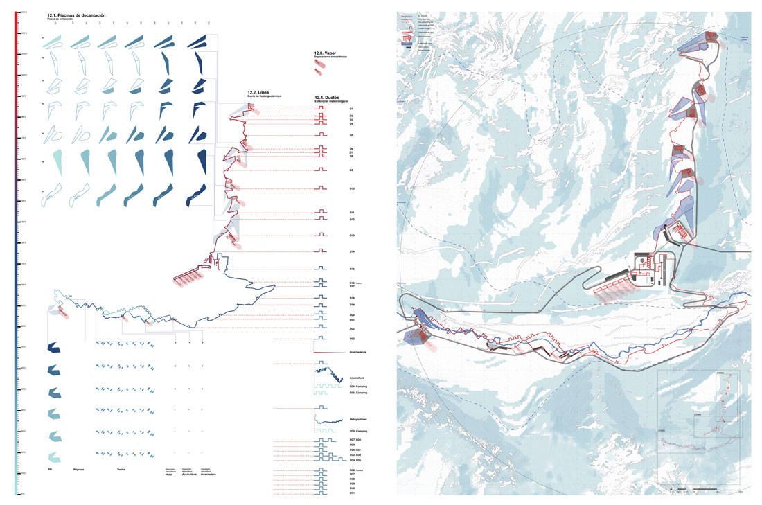
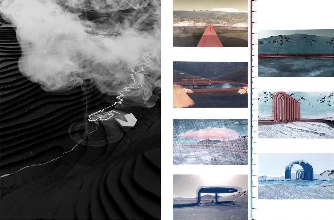
The High Andean territory of the Province of Chañaral, in the north of Chile is considered an area rich in fragile natural resources such as salt flats, highland lagoons and their ecosystems, and where a high potential for geothermal energy is combined with a pristine landscape of extreme touristic potential. The challenge is to assume and to integrate energy development as a new actor in this territory, which can activate and enhance local tourism, while promoting the conservation of the fragile natural resources.
This type of energy production can create new atmospheric and climatic conditions by having a heat source that contrasts with the cold temperature and wind conditions existing in the highlands of the Andes Mountains. The energy park is associated with a set of secondary programs related to the use of water at different temperatures, where recreational and touristic experiences coexist with production. The project is strategically located as a key point for the future bi-oceanic train corridor and is both a starting point and a supply base, both for local communities and for tourists and hiking tours operating in the high mountain range.
Solar Artifices
Cultivating the Atacama Desert between the sky and the ground
Location: Diego de Almagro, Atacama Region, Norte Chico, Chile
_ Argenys Ricardo Nelson Trimiño

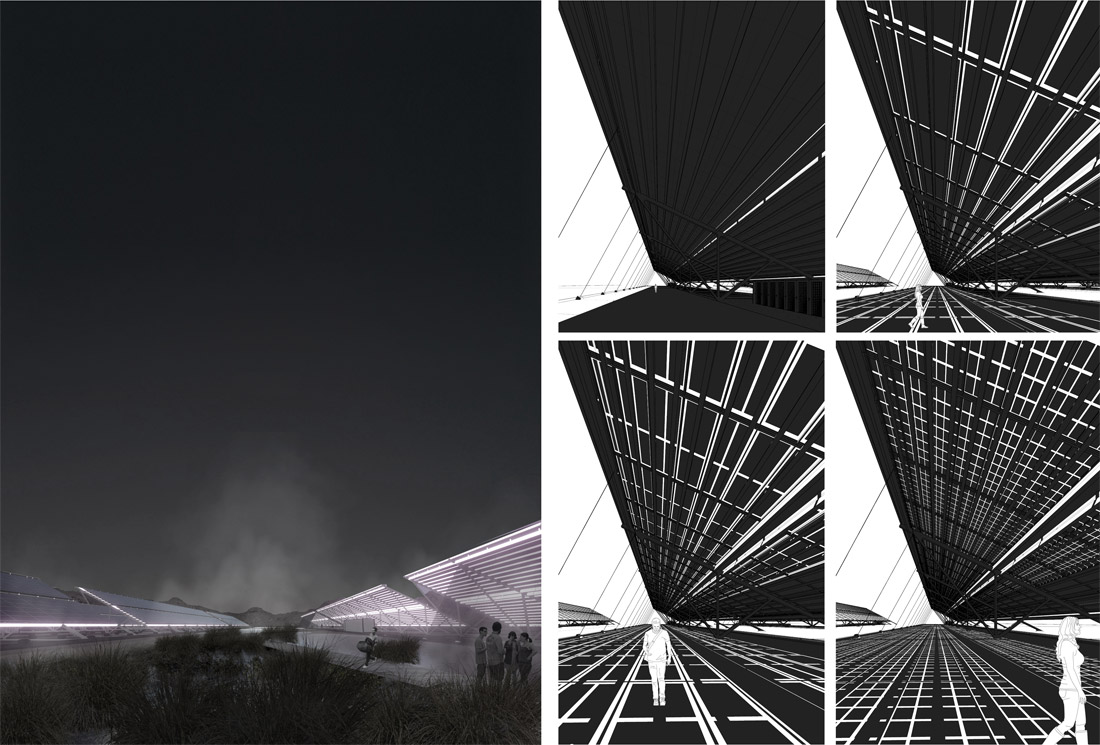
Diego de Almagro commune, located in the Atacama Desert, is considered one of the areas with the greatest potential for the production of solar energy worldwide, exceeding 2,500 hours of sunshine per year.
The infrastructure necessary for this production, due to its morphology, its orientation requirements, its inclination and elevation, fortuitously casts large shadows, a rare and valuable phenomenon in the desert context. The project takes the shade as a primary resource for the programmatic development of new agricultural economies and community activities.
The project proposes the use of photovoltaic parks as catalysts for the development of communities surrounding this type of power plant by reconfiguring the disaggregated relationship between the spatiality of the soil and the radiation from the sky, generating a productive landscape at different spatial levels, combining the artifice of solar infrastructure with local and multiscale agricultural production.
Aquastructura:
A new water infrastructure for the Atacama Desert
Place: Copiapó, Atacama Region, Norte Chico, Chile
_Andrea Bit
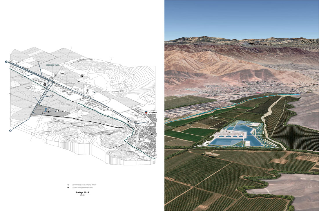
Due to the growing drought fueled by the climate crisis, in recent years a series of desalination plants have been built to supply water to the copper mining industry. Large underground aqueducts transport water from desalination plants (mostly powered by renewable energies) near the sea to mining areas up to 190 kilometers away and at an altitude of more than 4,000 msl.
Mining infrastructures become obsolete in short periods of time: generally a copper mine does not usually last more than 20 years. When a mine closes, all its infrastructure is abandoned, creating a new landscape of gigantic young industrial ruins spread out across the desert.
Aquastructura proposes the recycling of these infrastructures, using them in the fight against drought. The project is located near the Copiapó Valley, the last major agricultural area in northern Chile. The reuse of desalination plants could solve at least part of the water problems in this area, providing drinking water not only to the industry but also to the inhabitants and ensuring the agricultural irrigation of the valleys. The project proposal lies in the simultaneous use of the desalination and water purification process in a new water park usable for outdoor and sports activities that coexist with the design of the infrastructure for water management.
Hydric bonds
Mini hydroelectric plants as eco-programmatic articulators
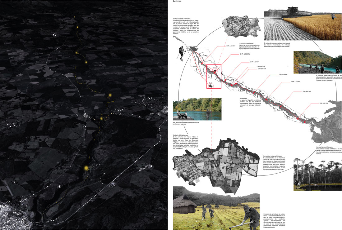
Location: Malleco River, Araucanía Region, Southern Chile
_Daniel De León
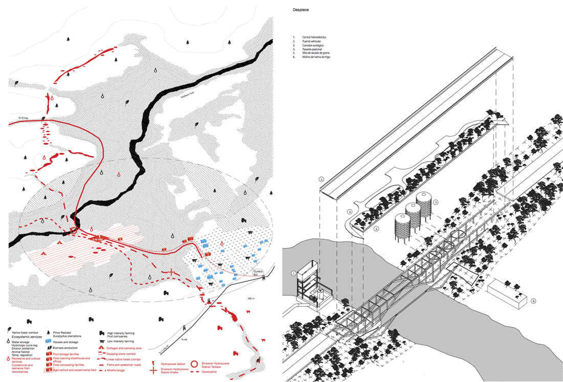
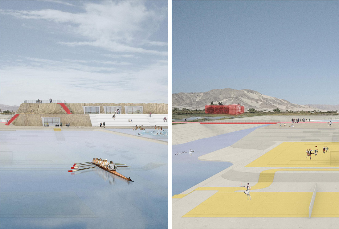
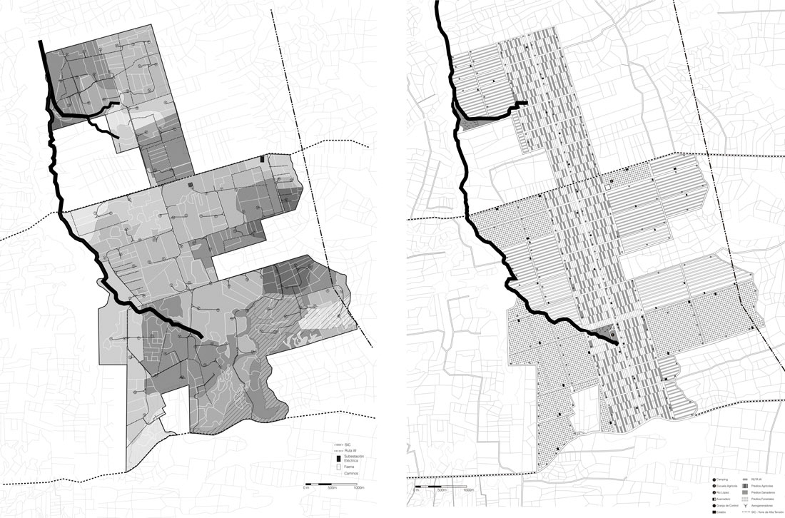
Given its location, geomorphology and flow, the Malleco River has been identified as suitable to be intervened by a series of small-scale run-of-the-river hydroelectric infrastructures over the next few years. The project proposes the redesign of these plants under strategies of integration through the river between the communities and the agricultural areas, as well as their immediate edges associated with native forest land and existing ecological corridors. The power plants are transformed into elements capable of articulating the different natural and artificial systems of the basin.
The challenge is to establish a hydroelectric axis that provides energy both to the Central Interconnected System and to the nearby communities, which channels sustainable community development, mitigates the effects caused by forest plantations and enables a road, a bridge and pedestrian and tourist connection to be built between the city of Collipulli and the Tolhuaca National Park, for the benefit of both local inhabitants and fauna. From the superposition of such variables (agricultural areas, remnant patches of native vegetation, hydroelectric plants, and their connections), the opportunity is observed to resume the momentum in the development of hydroelectric infrastructure, examine its parts, and turn them into tools for a new model of architectural articulation of the ecosystem through the energy and territorial design of the basin.
Eolica
Strategies for Productive and Energy Integration in rural contexts
Location: Llanquihue, Los Lagos Region, Southern Chile
_Juan Jose Castro
 The project proposes the challenge of studying linkage strategies between the existing traditional productive activities of the region – agricultural, forestry and grazing – and the new energy production of wind farms located in the rural areas of Llanquihue.
The current model of wind farms in the Region is characterized by the occupation of large areas of rural properties that were used for production, but when acquired by the companies that own the parks became monofunctional properties solely focused on receiving the energy infrastructure (wind towers, substations, works, etc.).
Through the real case study of the Aurora Wind Farm, the project proposes rethinking the logics of land occupation and formulating strategies for restructuring, hybridizing, and connecting the properties, avoiding friction and enhancing their circular relationships. Different activities and conditions can coexist in the same space through a polyfunctional property model in synergy with energy activity, respecting the underlying geographical and ecological conditions, and the pre-existing routes that cross the site, while generating a pole for local development through an experimental agricultural school.

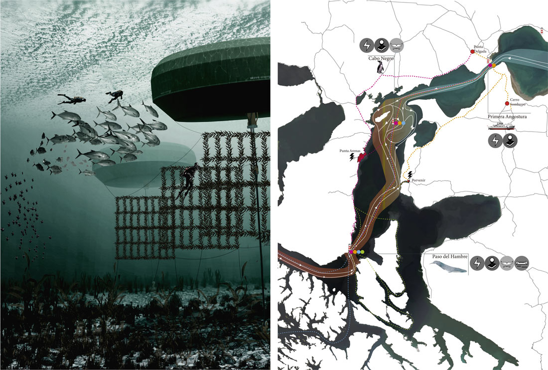
Maritorio Energético:
Wave energy as articulator of the ecosystem and heritage of the Strait of Magellan
Location: Cabo de San Isidro, Brunswick Peninsula, Magallanes and Chilean Antarctic Region, extreme South of Chile.
_Paola Salazar Opazo
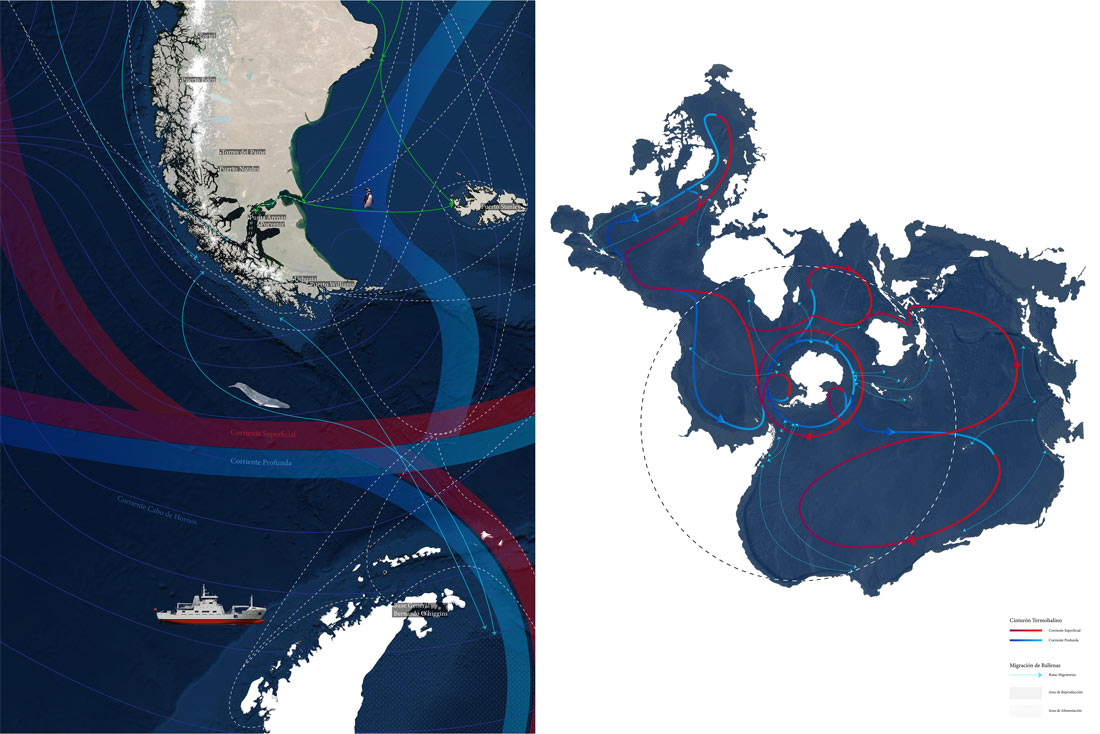
The Strait of Magellan, the oldest traffic gate between the Pacific and Atlantic oceans, continues to be a highly in-demand step in global maritime circuits. The archipelago is increasingly populated by ships, cruise ships and navies that have generated progressive ecosystem degradation due to the increase in the frequency and magnitude of oceanic noise. In turn, the geography and the forces of the tides and waves make the Strait of Magellan one of the areas with the greatest tidal and wave energy potential on the planet.
The project proposes a network of generation points that tackle the problem of energy autonomy while also contributing to addressing the problem of maritime traffic management in order to protect aquatic fauna, especially large aquatic mammals. Wave buoys generate energy through the tides while capturing the sounds of cetaceans and boats, calibrating information for navigation in real time and minimizing the negative effects of noise.
The energy farms are located in coastal areas once colonized by the old lighthouses of the Strait, both for their strategic sea / land locations, and for their symbolic and heritage value.