Markel Redondo first photographed Spain’s abundance of abandoned housing developments in 2010. Now, eight years later, he has retraced his footsteps.
The European economic crisis of the late 2000s hit Spain hard. “Due to a toxic combination of billions of euros worth of bad loans held by Spanish banks, and a real estate bubble that burst in spectacular style in 2007, Spain’s economy now faces multiple challenges,” says photographer Markel Redondo.
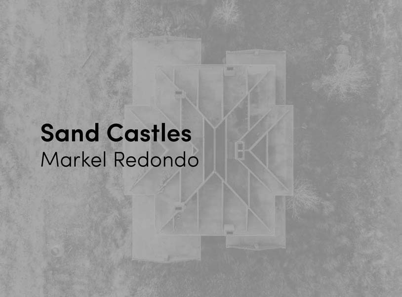
One of the many fallouts of the crisis forms the basis of Redondo’s latest body of work. Sand Castles (part II) documents a handful of the estimated 3.4 million houses that now stand empty and deserted throughout Spain. The developments – built in bucolic, and now largely deserted, surroundings to avoid the country’s tourist traps – were, according to Redondo, constructed by developers in “a dizzying rush to make the most of cheap loans and favourable government regulation.” They now litter the landscape.
Redondo first documented Spain’s abandoned housing developments between 2010 and 2012. Now, as winner of the DJI Drone Photography Award, he has retraced his footsteps, returning to the same sites and visiting new ones. Equipped with a car and a DJI Phantom 4 Pro drone, in early 2018 Redondo traversed southern Spain photographing the series. Over the course of 15 days, the photographer documented 12 developments. The elevated perspective provided by the drone gave the series a new edge. “It was mind blowing,” says Redondo, speaking of photographing the complexes from above. “I knew the developments were big, but I could not imagine the true extent of them.”
Redondo is one of two winners of the DJI Drone Photography Award and will join Tom Hegen in exhibiting his work at theprintspace gallery in London this April. In the interview that follows Redondo discusses the value of revisiting an existing body of work, how he hopes that the new perspective will provoke further discussion, and what has become of the housing developments almost 10 years since they were originally built.

How did Sand Castles initially come about?
Sand Castles started accidentally. In 2009, I was working on an assignment in southern Spain when I saw a group of abandoned houses in Andalusia. It stuck with me and, as the economic crisis in Spain was unfolding, I started researching similar developments. I spent a few years photographing abandoned and failed urban projects around Spain. I’d always had the idea of revisiting these places after a length of time to see what had changed.
Why is the topic of interest to you?
I am interested in the environment, so when I saw these developments and how the environment, often beautiful mountains or coastline, was being treated, it made me angry. I am also intrigued by the absurdity of the situation and how Spanish authorities allowed these places to exist.
 Talk me through your process of photographing the developments using a drone. Did you plot your route in advance? What sort of backdrops work best when shooting with the drone?
The first thing was to identify locations that I missed the first time. I read news stories and searched for updates, and also referenced architecture and photography books exploring similar issues. Next I used Google Earth to get an idea of how these developments might look from the air. At the beginning I wanted to photograph each location in the same way: from above and focused on shapes and details. I soon realised that panoramic shots, which put the housing developments in the context of the surrounding landscape, were powerful, so I combined the two.
For the panoramic shots, I always photographed with the same light – early in the morning and late in the evening – using the same angle. I wanted to present the developments like postcards, in the way that the developers and constructors would have imagined them, with nice light, but obviously with the feeling that something is wrong. For the detail shots – houses, roundabouts, roads – I always photographed at the same altitude.
Having a clear plan for each location helped a lot, as I knew what I was looking for. When places are vast and you only have a limited time to photograph, having a plan is crucial. I left some time to explore each location from the air looking for things that I might have missed, as well as trying out new techniques and recording video footage. Why revisit the sites almost 10 years later?
I was almost certain that the developments would be the same – they would be older but little would have changed. But I was curious, especially because I wanted to see these places, and some new ones, from the air. It is only from above that you are able to see their real extent.
Can you describe the atmosphere of these failed developments?
There is definitely an apocalyptic feeling to it. It is as if you are the last inhabitant in the world. The sites are completely deserted and the locations are difficult to reach, so, unless you are determined to go there, most people never see them. A lot of construction material, electric parts, sewage covers and copper has been stolen. There are rabbits everywhere.
You photographed a large number of different sites in various locations. Why was it important to show so many?
It is important to understand that this is not an isolated problem; it is something that has happened systematically across Spain. We need to ask why this is still happening and how we are going to fix the problem. What sort of reaction do you hope that the project will provoke? Are people aware that these vast developments exist and still stand abandoned?
People know that these developments exist. I hope this project will stand as a reminder that these places have not disappeared and it remains a problem that needs to be faced. We live in a society with huge housing problems, where many people cannot afford a place to live, yet Spain has more than three million empty homes.
What do the drone-shot photographs add to the project?
Using a drone gives the issue a new perspective. We have seen images of these developments before, but we haven’t seen their magnitude and the true extent of these vast constructions.
Did the new perspective provided by the drone throw up any surprises? Did it change the way you saw these developments?
It was mind blowing. I knew the developments were big, but I could not imagine their true extent. I had seen them from Google Earth, but a drone captures different angles and details. Using a drone allowed me to discover new things, shapes and details that you just don’t see from the ground or by satellite. It really felt like I was discovering something new.