


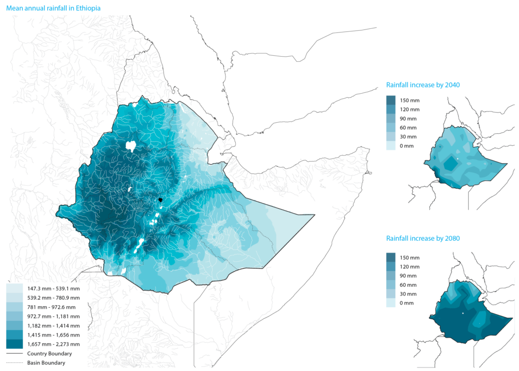
The combination of climate change effects and uncontrolled urban development in Addis Ababa is intensifying its vulnerability to flooding. There has been a noticeable upward trend in rainfall since the 1950s, with an increase of 17 mm per decade, resulting in a rise to the average of 1,171 mm between 1951 and 2002 (Conway et al. 2004, 87). This upward trend has continued in recent years, with the current average annual rainfall at around 1,200 mm (Arsiso et al. 2018, 22; Alemayehu et al. 2003, 4). However, forecasts predict that the city will experience critical fluctuations in precipitation intensity and frequency. Future climate simulations anticipate a potential increase in mean annual rainfall of between 35% and 50% by 2050, further amplifying the extremes of precipitation variability (CLUVA 2013). Despite the overall rise in rainfall, the city has also been experiencing drought conditions. Since the early 2000s, droughts have occurred for an average of three months per year. Droughts are projected to expand by 53% between 2040 and 2060, which will result in an additional 1.6 months of drought (CLUVA 2013; Dusseau et al. 2023, 6). Furthermore, the simulations also indicate a minimum 1.5° C increase in the annual temperatures of Addis Ababa, particularly in the southern, lower areas of the city (CLUVA 2013; Dusseau et al. 2023, 4).
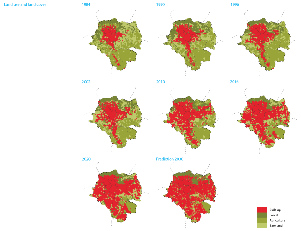
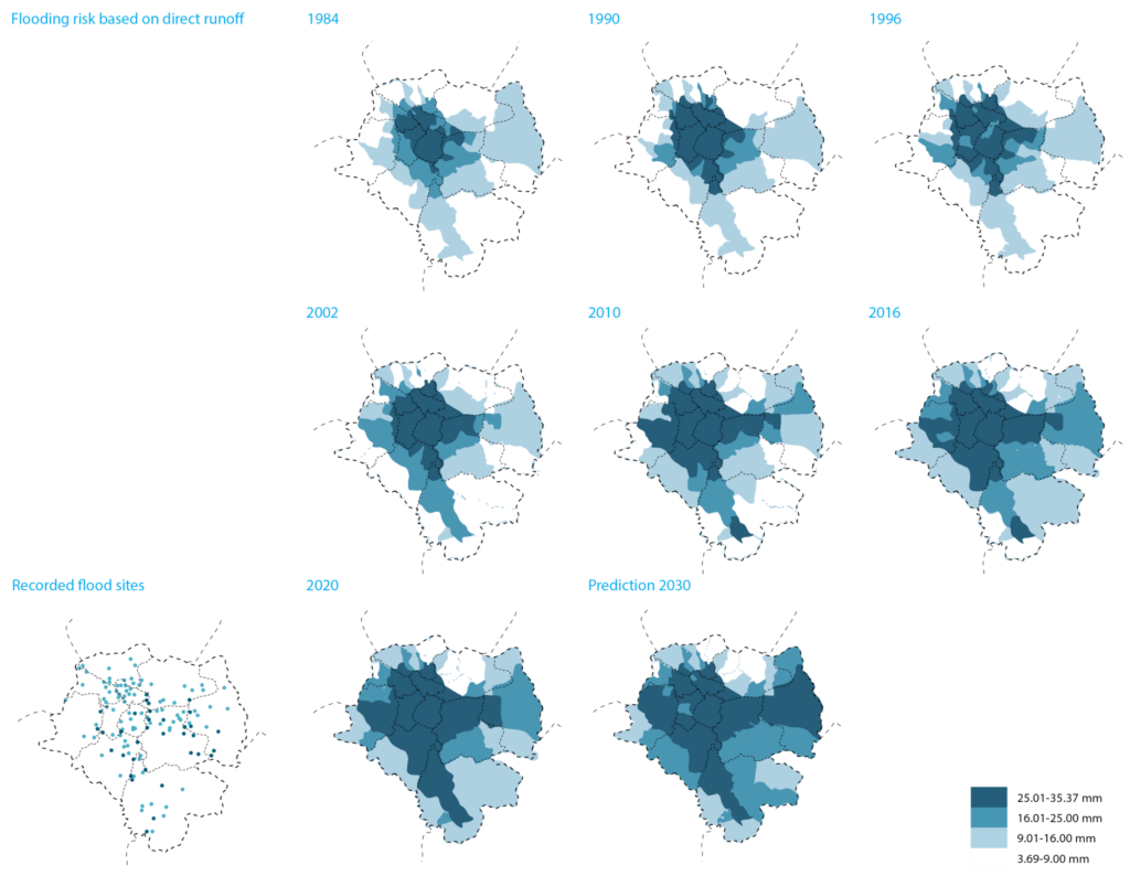
In addition, the rapid expansion of urban areas is worsening flooding exposure in the capital. For the past decades, the built environment has expanded by 4-5 km2 per year (UN-Habitat 2017, 2). The proportion of Addis Ababa covered by impervious surfaces, such as asphalt pavement, roads, and other built-up areas, has risen from an estimated 14% in 1984 to 53% in 2020 (Beshir and Song 2021, 1167; Moges 2019, 448). This issue has been further augmented by uncontrolled growth without proper planning and coordination, both within and outside the city limits. As a result, the dramatic and spontaneous expansion has severely intensified the number of residents at risk of flooding in Addis Ababa.
Both climate change and urban growth stressors are further aggravated by the combination of the natural characteristics of the city and the expansion of impermeable surfaces, as well as inadequate urban systems and planning implementation.
① NATURAL CHARACTERISTICS
The Subtropical Highland climate of Addis Ababa results in heavy rainfall during some specific months. The annual average precipitation in the capital is approximately 1,200 mm (Arsiso et al. 2018, 22; Alemayehu et al. 2003, 4). However, this varies across the city due to extreme variations in elevation between the northern and southern parts. Like the Ethiopian central region, the city experiences two distinct rainy seasons, Belg and Kiremt. Belg is a brief rainy season that occurs from March to May. It contributes approximately 30% to 35% of the yearly precipitation, with an average monthly rainfall of 100-200 mm, although this amount varies greatly through the different seasons and years (JICA 1998, 2-6). Kiremt is the extended rainy period, spanning from June to September, which accounts for the remaining 65% or 70% of the annual precipitation (Alemayehu et al. 2003, 15; de Wildt 2020, 13). In July and especially in August, the peak rainfall brings monthly averages of 260 mm and 270 mm, with the potential to reach around 300 mm (Bekele et al. 2023, 233; Gebremichael et al. 2014, 29). During the four rainy months of Kiremt, most river courses reach full capacity and flood their surroundings, creating floodplains, particularly in the central and southern low-lying areas of the city. The city experiences the Bega season from October to February, which is mainly dry, with some months receiving less than 10 mm of rainfall (JICA 1998, 2-12). The highest monthly evaporation is in the central months of this season, with an annual average of 1,445 mm (JICA 1998, 2-7). Overall, rainfall variability is contributing to both drought conditions and flooding.
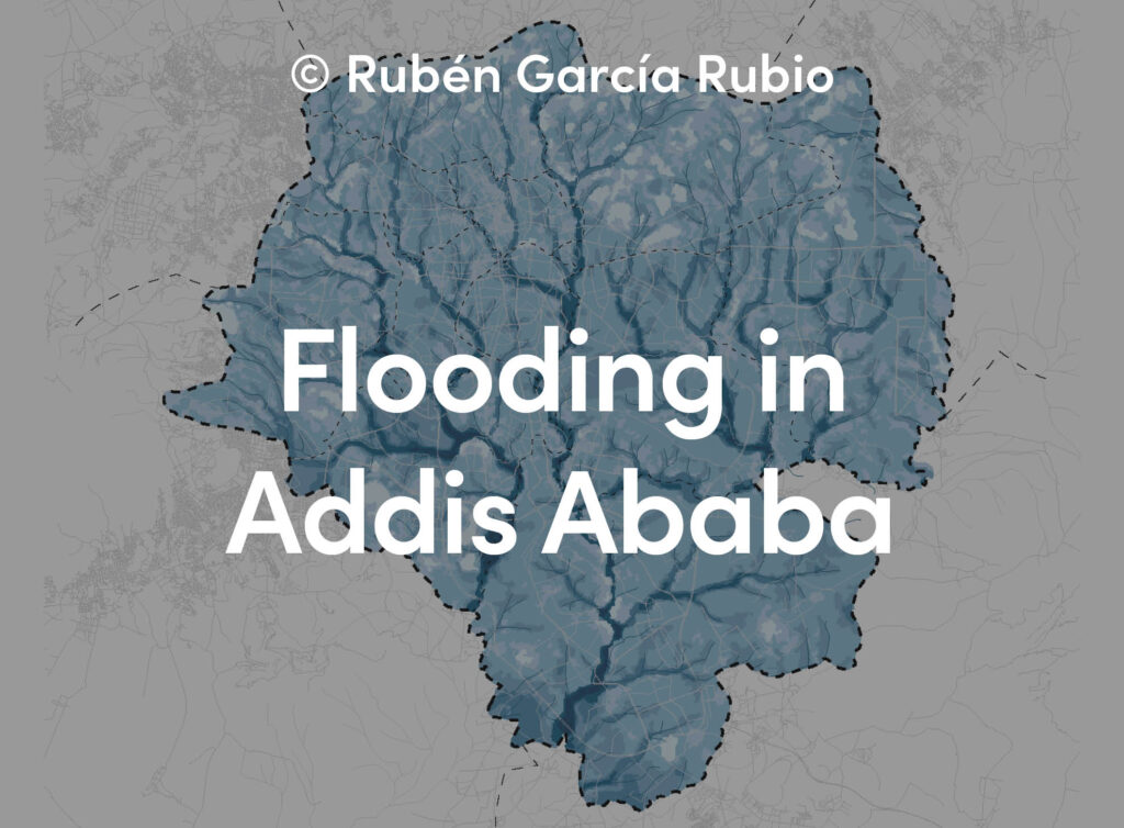
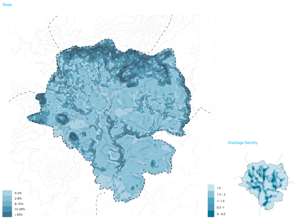
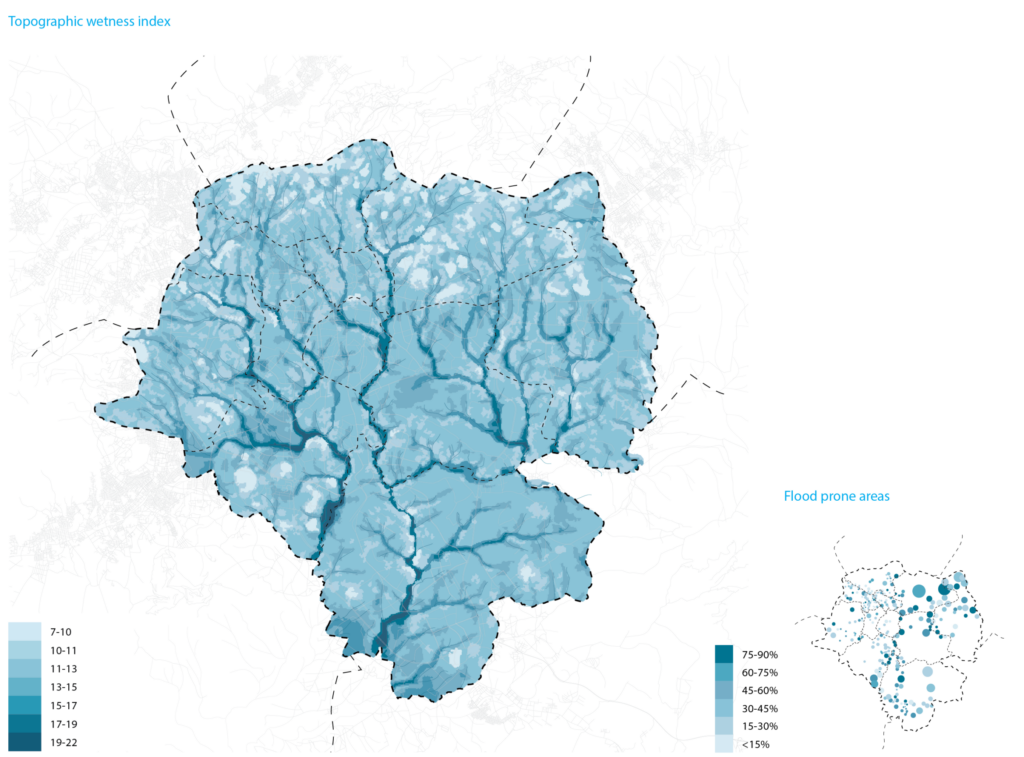
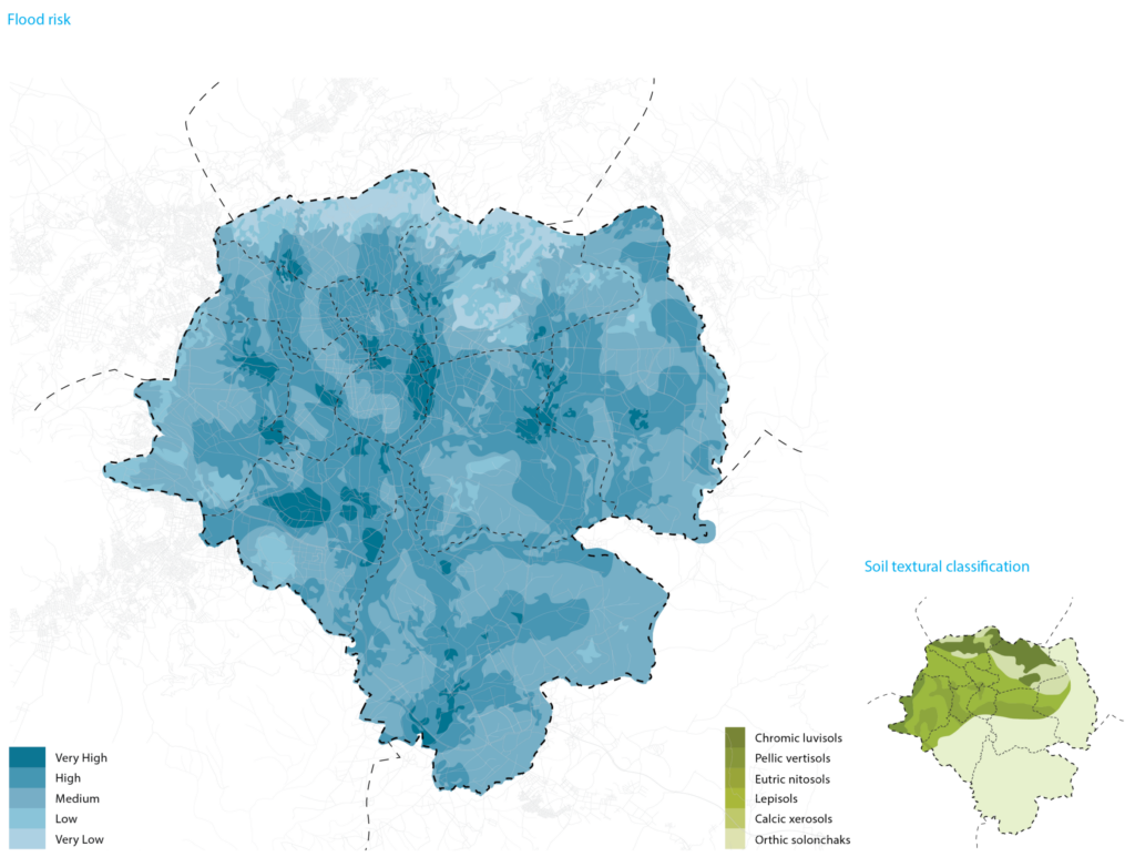
The city and its river system are situated in a region characterized by intense topographical conditions. The city is framed by the Entoto Mountain range (3,199 masl) to the north, Mount Yerer (3,100 masl) to the east, Mounts Wechecha (3,385 masl) and Menagesha (2,900 masl) to the west, and Mount Furi (2,839 masl) to the southwest (Alemayehu 2003, 3). Therefore, the topography features a significant slope from north to south, with a nearly 1,000 m elevation difference, while the east-to-west topography is characterized by the dendritic river system shaped by steep, undulating riverbeds and banks. The river network of Addis Ababa is formed by headwaters in the northern mountainous regions and flows to the plateaus (2,050 masl) south of the city. Due to the slope of the contours surrounding the river system, the terrain has a high capacity to retain water, resulting in the highest flood potential, or the highest topographical wetness index, occurring mainly on the riverbanks (Jalayer et al. 2014, 987). In general, the city efficiently drains gravitationally, with the mountainous peaks and valleys channeling water through the river system to the low-lying flood plains, although this area often floods because of continuous encroachment of the built environment on the riverbanks.
② PERMEABILITY
The variety and permeability of soils in Addis Ababa significantly influence its flood mitigation capabilities. The city has two primary soil typologies: vertisols and nitisols. Both vertisols and nitisols typically have a clay soil texture and absorb about 12% moisture (MEFCC 2022, 60). However, vertisols contain higher clay contents, approximately 60% clay, which do not allow water to percolate efficiently, while nitisols are well-draining (Horvath 1966, 23). The predominant soil within the city boundary is pellic vertisols, which cover 277.23 km2, especially in the southern and northeastern portions of the city (Feyissa 2018a, 7-8). The second largest soil type is eutric nitisols, which constitute 111.55 km2 of the northwestern and north-central areas of Addis Ababa (Feyissa 2018a, 7-8). Vertisols are characteristically very dark, black soils that tend to form in flatter areas like the plateaus of the south, while nitisols exhibit a reddish-brown pigment typical of both gentle and steep slopes in the north part of the city. The layer of high-clay soils in the northern mountainous region is thinner, while in the southern plains, the deposits are very thick, reaching depths of up to 40 m (Engida 2001, 3). The estimated infiltration is 1 mm/h for pellic vertisols and 72 mm/h for eutric nitisols (MEFCC 2022, 60). As a result, the prevalent high-clay vertisols in Addis Ababa are better suited for water retention but subsequently have a higher potential for flooding, particularly in the flat, southern parts of the city. Furthermore, the drying and shrinking of the clay-based soils within the stormwater and sewerage pipes create cracks and leaks (Worku 2017, 113).
The continuous reduction of permeable areas in Addis Ababa is significantly compromising its overall permeability, consequently affecting its ability to alleviate flooding. Over the last four decades, the city boundary has more than doubled to encompass the current 540 km2 (Gebremichael et al. 2014, 2; Worku 2022, 4). However, the green areas of the city have radically declined in recent years, being replaced by the built environment. Between 1984 and 2020, the green belt of the city, which consists of a combination of forest, agricultural, and bare land, was reduced by half, from 420 km2 to 207 km2 (Beshir and Song 2021, 1178). Today, only certain parts of the forest reserves in the north and bare lands in the southeast remain as large permeable areas within the boundaries of the capital from the former green belt. The loss of vegetation and open green spaces not only impacts pollution mitigation, carbon sequestration, the urban heat island effect, and general water security, but also directly influences run-off regulation and flooding. In general, the loss of green spaces contributes about 40% to flooding and landslides in Addis Ababa (AACA and Resilient Cities Network 2020, 44).
Conversely, the expansion of the built environment is increasing the impermeable surfaces in Addis Ababa. In the last decades, the built-up areas in the city have risen from 80.1 km2 in 1984 to 287.9 km2 in 2020, representing a substantial 259.4% growth (Beshir and Song 2021, 1178). More specifically, the built environment has escalated from 14% in 1984 to 53% in 2020 within the current city boundaries (Beshir and Song 2021, 1178). This expansion has reduced green spaces and encroached on approximately 10% of the natural flood plains of Addis Ababa, resulting in the channelization of rivers and the loss of natural drainage (Backhaus 2017, 7). As a result, there is now a higher risk of flooding and erosion, particularly in downstream areas of the city.
③ DRAINAGE SYSTEM
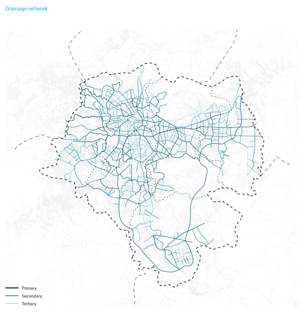
The existing drainage system in Addis Ababa is inefficient. The responsibility for managing the drainage network in the city lies with the Addis Ababa City Roads Authority (AACRA). This system primarily consists of an independent network of open ditches and underground pipes designed to transport untreated runoff water to the rivers. The network comprises four hierarchical types of drains with circular, rectangular, and some trapezoidal geometries of varying sizes. These drains are predominantly constructed using masonry and some with prefabricated concrete (Adugna et al. 2019, 8; Belete 2011, 223). Due to the extreme topography of the city, both open and underground drains rely on gravitational force, primarily north-south (Sering Ingegneria. n.d.). This network is estimated to follow the same slope as the road surface, as most parts of the system are located beneath or alongside the roads. However, many drainage channels are found in very steep areas of the city, which are susceptible to erosion due to the high speeds of stormwater flow during extreme events. Additionally, many roads are poorly designed, have an incorrect slope, or are weakly integrated with the network, hindering the proper drainage of surface water into the drains (Peña 2020).
Furthermore, the current drainage network is exceedingly aging. In several areas of the capital, between 47% and 63% of the total drainage lines are severely degraded, with some sections of the network in the old part of the city dating back as far as 100 years (Jemberie and Melesse 2021, 2; Tafete 2013, 45-47). Moreover, inappropriate construction has resulted in some drainage lines failing mere months after installation (Tafete 2013, 56).
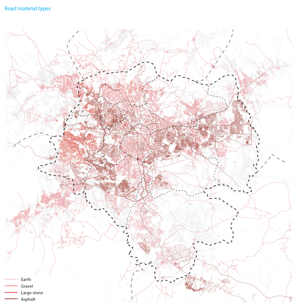
The drainage infrastructure in Addis Ababa extends throughout approximately half of the city. Although there is limited information, the network covers around 50% of the older parts of the city and nearly 60% of the newer areas (Adugna et al. 2019, 14), which is an estimated rough length of 2,000 km of current roads with drainage (Belete 2011, 223; Tafete 2013, 45-47). Generally, the drainage systems integrated into major asphalted roads are in good condition, whereas the drains of secondary roads with stone or gravel surfaces are often deteriorated. There are still a significant number of roads without proper or any drainage, which is leading to road damage, impassable streets and sidewalks, and extensive urban flooding within the city, as most of the stormwater freely runs off to low areas and rivers.
Despite reaching most parts of Addis Ababa, the capacity of the drainage system is insufficient. The present built environment of the city spans nearly 300 km2 and generates an estimated 350 million m3/year of stormwater runoff (Backhaus 2017, 7). Moreover, in certain areas, 72% of the pipes are currently oversized to account for exceeded capacity during rainy seasons (Adugna et al. 2019, 1). However, it is estimated that water runoff in the city often surpasses the capacity of certain drainage lines today, sometimes by as much as 200% or 300% (Tafete 2013, 41-43, 73). In several woredas, only between 34% and 44% of the drainage lines can safely carry runoff to the waterways (Tafete 2013, 45, 72-73). As the city expands, the estimated annual peak runoff will increase at a growth rate beyond 2.5%, which will aggravate the inadequacy of the system (Tafete 2013, 41-43).
The insufficiency of the drainage network is further exacerbated by its misuse. Despite advocacy for separate networks in Addis Ababa for some time, the drainage system is often utilized as part of the sewage system. However, due to low coverage, high implementation costs, and unqualified workmanship, the coexistence and independence of both systems are challenged (CWRA 2021, 43). As a result, citizens make illegal and inappropriate connections to either system, disregarding the nature of the liquid. Consequently, the sewage system serves as an informal drainage infrastructure in many areas of the city, while the drainage network acts as a secondary sewer structure. Between 63% and 81% of open masonry drains in some areas contain illegally dumped waste (Adugna et al. 2019, 14). This has resulted in blocked and overloaded systems, excessive stormwater pollution, and a higher risk of flooding.
 ④ FLOODING TYPES
Addis Ababa is highly susceptible to different types of flooding. This condition is primarily due to the combination of extreme elevation differences within the city, steep topography alongside low-lying areas, and intense and short periods of rainfall. The problem is further exacerbated by the reduction of green areas and permeable surfaces, the inadequate and misused drainage systems, the deforestation of the northern and eastern mountains, and the generalized encroachment of the riverbanks and river channels through the construction of diverse structures and the disposal of solid waste.
The city predominantly experiences river or fluvial flooding. The river system in Addis Ababa heavily relies on rainwater, resulting in highly seasonal rivers. For instance, the Akaki River has an estimated average annual runoff of 8.8 m3/sec, with a wide variation from approximately 1.39 m3/sec during the dry season to 43.82 m3/sec at the peak of the rainy season (JICA 1998, 2-8, 2-9). During the intense rainy seasons, the river water reaches high flow rates in the northern steep areas of the city and rapidly reaches the southern lower-elevation valleys, with an average duration of the high water between three and six hours (JICA 1998, 2-41). In some areas, the peak discharge during flooding can increase from 180% to 300% of the river capacity (Moges et al. 2019, 452). Traditionally, the natural features of the city have prevented severe drainage congestion (JICA 1998, 4-21). However, the recent encroachment of the rivers has drastically reduced their floodplains in the last decades, multiplying the flooding events, particularly in the middle and low parts of the city.
The characteristic extreme and brief rain events of the region also cause notable flash and surface flooding in Addis Ababa. Large upstream rainstorms with around 100 mm of rainfall in 24 hours can cause flash floods within a very short period of two to three hours (Gebremichael 2014, 23). This type of flooding is highly destructive due to the rapid flow of water caused by the steep terrain. This impact is especially concerning in the deforested northern mountain areas of the city, where some of the most vulnerable communities of the capital reside, as it can also result in landslides. As the stormwater reaches the middle and low-lying areas of Addis Ababa, it can become surface flooding due to the limited capacity of the drainage system and the abundance of impervious surfaces. Together, the expansion of the built environment, without a proportional improvement in the drainage system, has resulted in a 61% increase in surface runoff between 1984 and 2002 and ultimately produced a 60% increase in flood volume (Moges et al. 2019, 450, 452).
To a lesser degree, Addis Ababa can also suffer groundwater flooding. During the rainy season, when almost three-quarters of the annual precipitation occurs, water can either steadily or rapidly collect and raise the water table, particularly flooding flat and depressed areas in the center south of the city (Worku 2022, 18). Additionally, groundwater flooding can occur in permeable, river-connected alluvial aquifers when water rises too quickly.
⑤ FLOODING VULNERABILITY
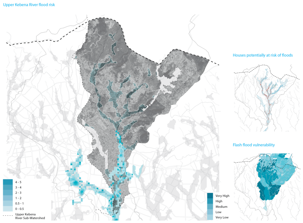
The escalating frequency of flooding events is emphasizing the vulnerability of Addis Ababa. The number of severely flooded areas in the city surged by over 100% from 1984 to 2020, causing damage to residences and businesses, as well as disrupting transportation systems and pedestrian connections (Beshir and Song 2021, 1184). In 2017 alone, there were 76 individual flood events in Addis Ababa (Jemberie and Melesse 2021, 2). An estimated 67% of the capital population resides in flood-prone zones. Additionally, over half of the flood-prone homes are constructed using traditional mud and wood, leaving them highly exposed to flood events (CLUVA 2013). Overall, more than 121,000 houses, along with 1,000 governmental and private institutions, are situated in high-risk flooding areas of the city (Capital Newspaper 2018; Jemberie and Melesse 2021, 2). With the ongoing influence of climate change on rainfall intensity and variability, the frequency of urban flood events is expected to rise and multiply the susceptibility to flooding in the city.
⑥ FLOODING COEXISTENCE
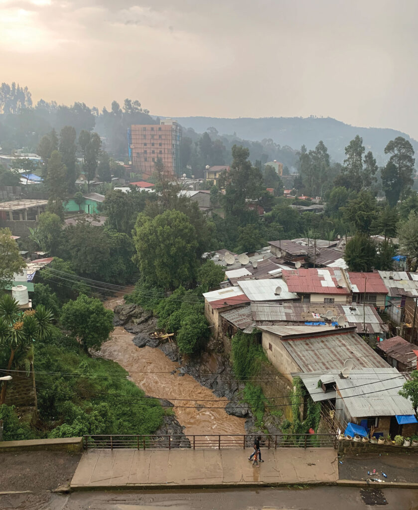
The river system in Addis Ababa is a crucial infrastructure for flooding control. However, these rivers have now become major flooding hazards for the city, primarily due to its encroachment on their banks. Many structures, particularly homes in unplanned settlements inhabited by the most vulnerable communities, have been built on riverbanks and low-lying floodplains. Roughly 186,000 households are located within 100 m of the rivers, exposing them to a moderate to high risk of flooding due to their proximity (Yohannes 2015, 1-2). Consequently, it is critical to recover the rivers and their natural dynamics to mitigate seasonal flooding and to ensure the direct safety of the citizens of Addis Ababa. Moreover, the natural restoration of the riverbanks can also support the development of urban agriculture and new housing models, promoting a harmonious coexistence between residents and the rivers.
Similarly, the streets of the city can support the management of flooding events. The high-intensity and increasingly erratic rainfall patterns in Addis Ababa also have significant impacts on runoff, causing street flooding, eroding roads, and blocking infrastructure. The current stormwater management system is compromised due to various drainage structure failures. As a result, 38.5% of these failures directly damage street pavements, 18% cause transportation disruptions, 16% cause traffic accidents, and 16% impact pedestrians (Jemberie et al. 2023, 11). Excessive flooding during the rainy seasons turns the streets of Addis Ababa into impassable rivers, particularly for pedestrians. Traveling in these conditions becomes challenging and dangerous, even for vehicles. It directly affects the ability of the residents to access basic facilities, attend school, and travel to work. Thus, incorporating nature-based strategies to manage stormwater into the design of the current street network can effectively enhance the drainage system in the city, as well as address other urban challenges through the re-naturalization of the city. This approach can also facilitate the natural cleaning and filtration of runoff before it reaches the river, thereby contributing to an improved water cycle in Addis Ababa.
Addis Ababa needs to change the perception of excess water from being a problem to being a solution. Despite receiving an annual significant amount of rainfall comparable to cities in different latitudes, the city experiences this rainfall only for a few months. This stormwater is a valuable resource, especially for a location heavily reliant on fresh water and facing increasingly frequent droughts. However, most of this water, which is often polluted, ends up in a river system that quickly carries it away from the city. Hence, Addis Ababa should implement various strategies to collect, store, and recycle, as well as clean and filter stormwater, to ensure a sustainable future for the city.