In the early twenty-first century, urbanization is being generalized across places, landscapes, territories and scales. These newly emergent geographies of urbanization are superseding inherited patterns of cityness and exploding the traditional boundary between the city and the non-city.
As emphasized by global city theorists, economic geographers and agglomeration economists, large-scale metropolitan regions remain major engines of early twenty-first century capitalist development. Processes of agglomeration and sociospatial concentration are as fundamental as ever to the basic logics of capital accumulation.
Nonetheless, under contemporary conditions, traditional visions of the city as a distinctive, coherently bounded type of settlement space are being rendered obsolete. The long taken-for-granted separation of such densely concentrated settlement zones from the putatively non-urban spaces (suburban, peri-urban, rural or ‘natural’) that surround them has become thoroughly problematic.
The erstwhile non-urban realm is today being engulfed by an imploding and exploding urbanization process at all spatial scales. Putatively peripheral, remote or natural spaces that were once assumed to lie ‘outside’ or ‘beyond’ the urban condition are now being tendentially instrumentalized —through a combination of capital accumulation strategies, state regulatory projects and design/planning techniques—to serve the needs and manage the by-products and crisis-tendencies of generalized planetary urbanization. Regardless of their morphological arrangement, population density, infrastructural configuration or biotic composition, such operational landscapes have become strategically essential to the everyday practices, socio-metabolic cycles and long-term rhythms of worldwide capitalist urbanization.
These tumultuous transformations are extremely difficult to grasp, much less to visualize, because our inherited intellectual vocabularies, conceptual horizons and cartographic methods are largely derived from a formation of urbanization that has now been superseded. Yet, the obsolescence of our epistemological tools for understanding and confronting urban questions creates urgent challenges for theorists, designers, planners, cartographers and others who aspire to reshape the rapidly urbanizing landscapes of our planet at any spatial scale. In the absence of adequate concepts, methods and cartographies for deciphering the new forms of urbanization that are remaking the world, our collective capacity to envision, and ultimately to produce, a more socially just, democratic and ecologically viable planetary habitat, is severely constrained.
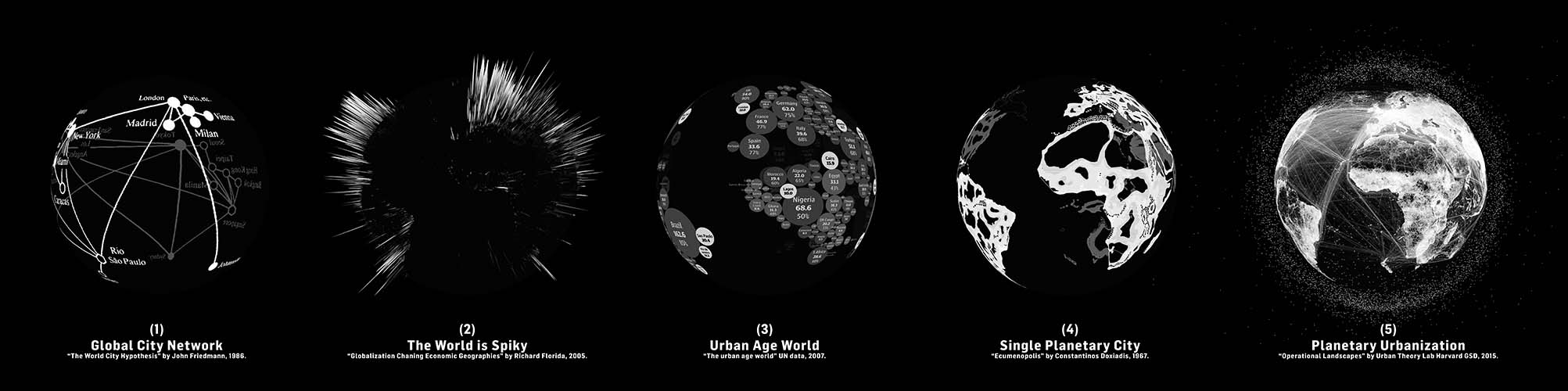
During the last several decades, amidst the world-historical transformations of urban(izing) landscapes just described, new visualizations of diverse terrestrial conditions—from population distributions and densities, land use patterns and infrastructural arrangements to human environmental impacts—have been produced and widely disseminated. Unlike traditional representations of such conditions, which have usually been derived from census and topographic surveys, these new visualizations have been based upon the use of remote sensing technologies (in particular, satellites) and new techniques of geospatial analysis (such as geographic information systems [GIS]) to measure and map the phenomena under investigation. Originally a rarified form of spatial information that was tightly controlled by military and governmental organizations, today remotely sensed images of socioterrestrial conditions have become ubiquitous in diverse realms, including the social and environmental sciences; architecture, planning, design and civil engineering; as well as in journalism, film, the arts and social media. From the popular diffusion of nighttime lights images and the everyday use of global positioning systems (GPS) and Google Earth to the proliferation of satellite images derived from more specialized forms of spatial data on populations, settlements, infrastructures and landscapes, geospatial visualizations have become a commonplace reference point used to illustrate or justify diverse interpretations of the world’s built and unbuilt landscapes at nearly every conceivable spatial scale.
Can these new geospatial imaging techniques be harnessed to produce new understandings and cartographies of early twenty-first century urbanization processes? Does remote sensing offer a useful tool for re-imagining the urban/non-urban divide in the age of generalized urbanization? These are our central questions in this booklet.
Our views are decidedly ambivalent. While we believe that geospatial data and images can indeed be used to illuminate and influence urbanization processes, their deployment to date has been severely hindered by the perpetuation of the photographic illusion—the treatment of geospatial visualizations as if they were mimetic representations of spatial conditions and distributions “on the ground,” much in the way that a photograph is often taken to be a “mirror image” of the person, object or site it is representing. In fact, such visualizations are never a direct “mirror of nature” (Richard Rorty), but are invariably mediated through a combination of underlying theoretical assumptions manifested in spatial taxonomies and techniques of data processing through which spatial information is assembled to “pixelate,” color-code and bring into focus an image.
For this reason, a critique of geospatial ideology is a necessary precondition for any reflexive appropriation of remotely sensed data and images in investigations of contemporary urbanization processes. By revealing the pervasive yet often hidden metageographical assumptions that invariably underpin geospatial visualizations, we can begin to subject them to critical interrogation and, where appropriate, radical reinvention.
More generally, the analysis and critique developed in this book is intended to caution all consumers of geospatial images and maps, within and beyond the design disciplines, to recognize their theoretically mediated, technically constructed and therefore fundamentally hermeneutic character, and thereby to supersede the epistemology of “naïve objectivism” that currently prevails. For, even in their most aesthetically appealing, graphically crisp and apparently fine-grained forms, such images and maps are never neutral depictions of the real, but are permeated with assumptions, interpretations and classifications that, quite literally, constitute the spatial information on display. One of the most pervasive among such assumptions—that the urban is a bounded, relatively self-contained unit—will be put into relief and subjected to critical interrogation below.
The epistemological upshot of these considerations is a double-call for (1) new spatial representations and visualizations of urban theories; and (2) theoretically self-reflexive approaches to geospatial visualizations of the urban. Unless urban theories can be translated into spatial representations that are more appropriate to emergent conditions, inherited metageographical assumptions and binarisms will continue to confuse our understanding of urban processes, and will thus impede our capacity to shape them. By the same token, unless the theoretical assumptions underlying dominant cartographic representations of the urban are clarified, interrogated and re-invented, the latter will perpetuate the photographic illusion, and further entrench the ideological confusion that surrounds so much of current urban research and practice.