Waterfronts are magical places where the water meets the land and people can reconnect with their waterways. But during the industrial revolution, many communities made waterways their backdoor. Detroit was no exception with its Detroit River. For two centuries, the Detroit River – a 32-mile connecting channel that links the upper Great Lakes with the lower Great Lakes and a shard resource between the United States and Canada – was perceived as a working river that supported commerce and technological progress.
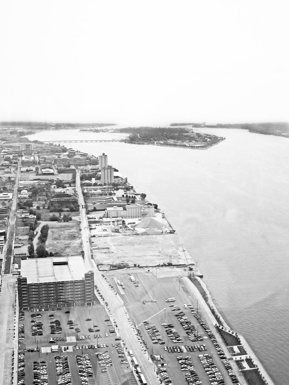
It was 1989, and I was attending a meeting on the 17th floor of Tower 600 of the Renaissance Center in Detroit that faces east and upriver towards Belle Isle, a 980-acre island park in the middle of the Detroit River. It was a striking view of material storage piles, surface parking lots, dilapidated warehouse buildings, and three sets of cement silos. I couldn’t help but think that these cement silos were like sentinel solders standing guard on Detroit’s east waterfront that had long lost its industrial glory. Even though much of the industry had long left this waterfront district, these sentinel solders were remaining true to their orders given many decades before.
Clearly, Detroit was an industrial town with primarily a working riverfront that supported industry and commerce. However, times had changed. There were fewer people and industries, and much underutilized and undervalued riverfront land. Urban planners and landscape architects describe this as a post-industrial waterfront.
During the 1960s, the Detroit River was one of the most polluted rivers in the United States because it was part of the industrial heartland, and Detroit was both Arsenal of Democracy and the automobile capital of the United States. Oil pollution was causing winter waterfowl kills, phosphorus pollution was causing accelerated enrichment or eutrophication, municipalities and industries were routinely cited for violations of water quality standards, toxic substances’ contamination was causing both fish consumption advisories and reproductive problems in wildlife, and land use practices had destroyed wetlands. Compounding the problem, Detroit became indifferent to the water pollution that was perceived as just part of the cost of doing business. It was no surprise that Detroiters long lost connection to their river.
As far back as the 1970s, the International Joint Commission, set up under the 1909 U.S.-Canada Boundary Waters Treaty to prevent and resolve disputes concerning water quantity and quality, identified the Detroit River as a “pollution hot spot” or Great Lakes Area of Concern. Today, more than 40 years of pollution prevention and control have resulted in substantial environmental improvements:
· more than 97% reduction in oil releases;
· more than 98% decrease in phosphorus discharges;
· 4,600 tons/day decrease in chloride discharges;
· substantial improvement in municipal wastewater treatment by upgrading all plants from primary treatment to secondary treatment with phosphorus removal;
· 95% reduction in untreated waste from combined sewer overflow discharges (i.e., in sewerage systems that carry both sanitary sewage and storm water runoff, the portion of the flow that goes untreated into rivers or lakes because of wastewater treatment plant overloading during storms);
· 85% reduction in mercury in fish;
· 91% decline in PCBs, 92% decline in DDE, and 94% decline in TCDD in herring gull eggs from Fighting Island; and
· remediation of 1 million cubic yards of contaminated sediment at a cost of more than $154 million.
This cleanup of the Detroit River has resulted in one of the most remarkable ecological recovery stories in North America. In the late 1960s, when the Detroit River was one of the most polluted rivers in North America, no bald eagles, peregrine falcons, or osprey were reproducing in the Detroit River watershed, nor lake sturgeon or lake whitefish in the river. Beaver had disappeared, as had the common terns from the 980-acre island park called Belle Isle. The Great Lakes Fishery Commission declared walleye to be in a state of crisis. Today, bald eagles, peregrine falcons, osprey, lake sturgeon, and lake whitefish are reproducing again, beaver are back, common terns are back on Belle Isle, and the Detroit River is now considered part of the “Walleye Capital of the World” with annual walleye tournaments offering $500,000 in prize money.
This ecological recovery is remarkable, but restoration is not complete. Monitoring has documented the following environmental and natural resource challenges: population growth, transportation expansion, and land use changes; nonpoint source pollution; toxic substances contamination; habitat loss and degradation; introduction of exotic species; and climate change.
Clearly, more needs to be done to fully realize long-term goals of restoring the physical, chemical, and biological integrity of the Detroit River. However, the progress achieved to date, the informed, engaged, and vocal stakeholders and nongovernmental organizations involved, and the broad-based desire to create a sense of place in these watersheds bodes well for further improvement and recovery. Scientists continue to worry about societal complacency. The 1960s were clearly an environmental “tipping point”, when there was an urgent need to prevent and control pollution. If appropriate action was not taken, society could see irreversible damage or harm to our ecosystems. We cannot afford to reach another “tipping point.” We need to make sure that we sustain our research and monitoring programs, ensure that they are closely coupled with management efforts in the spirit of adaptive management that assesses status, sets priorities, and takes action in an iterative fashion for continuous improvement, and ensure that the resulting scientific information and knowledge are translated for decision-makers and laypersons, and are broadly disseminated. We need to continue to remediate and restore these ecosystems using all tools in our collective toolbox, including actions by households and individuals. We also need to invest in capacity building, sustain and indeed grow our nongovernmental organizations, and place a higher priority on education to help develop a stewardship and conservation ethic and the next generation of environmentalists, conservationists, and sustainability entrepreneurs.
Over time, there were numerous historical attempts in Detroit to create a more open and accessible riverfront, starting with Detroit Mayor Hazen Pingree who, in 1889, proposed a plan for an extended park along Detroit’s riverfront. However, all of them failed. By the 1990s, Detroiters began to rediscover their river because of cleaner water and wanted to improve public access to it and redevelop it in a fashion that would improve quality of life, catalyze economic development, and help change the perception of Detroit from that of a Rust Belt city to one that is actively engaged in sustainable redevelopment.
Out of this growing public interest to reconnect to the Detroit River, the ecological recovery, and strong public and private support to revitalize Detroit, public sentiment coalesced to transform the riverfront into a beautiful, exciting, safe, accessible world-class gathering place for all in the early 2000s. This became most evident in 2001 when four things occurred that would be a foretaste of a future riverfront greenway:
· General Motors completed a $500 million renovation of the Renaissance Center, switching the front door from facing Jefferson Avenue to facing the Detroit River with the construction of a five-story glass atrium called the Winter Garden;
· Community Foundation for Southeast Michigan launched its Greenways Initiative that had raised $25 million to be given away in grants to communities to help make match requirements on federal and state greenways grants;
· United Auto Workers and General Motors opened a 65,000-square foot UAW-GM Training Center that provided a riverfront greenway easement; and
· Detroit celebrated its 300th anniversary, which included restoration of Campus Martius Park as its legacy project of Detroit 300 and placement of an Underground Railroad Monument on the riverfront.
Together, these four significant developments gave further traction to the desire for a connected riverfront greenway and gave confidence to the City of Detroit to bring key stakeholders together to create an organization that would lead the effort.
In 2002, the City of Detroit commissioned a Blue-Ribbon Committee to develop a new vision for Detroit’s riverfront as a gathering place for Detroiters, their families, friends, and visitors. That same year, The Kresge Foundation committed $50 million in a series of challenge grants over a five-year period to help build a Detroit RiverWalk, the largest gift at that time in the history of the Foundation. In direct response to the work of the Blue-Ribbon Committee, the $50 million commitment of The Kresge Foundation, and support of General Motors Corporation, the Detroit Riverfront Conservancy was established in 2003 as a nonprofit organization whose mission was to develop public access to Detroit’s riverfront and to have this development serve as an anchor for economic revitalization. After more than a century of trying, a Detroit RiverWalk was finally becoming a reality.
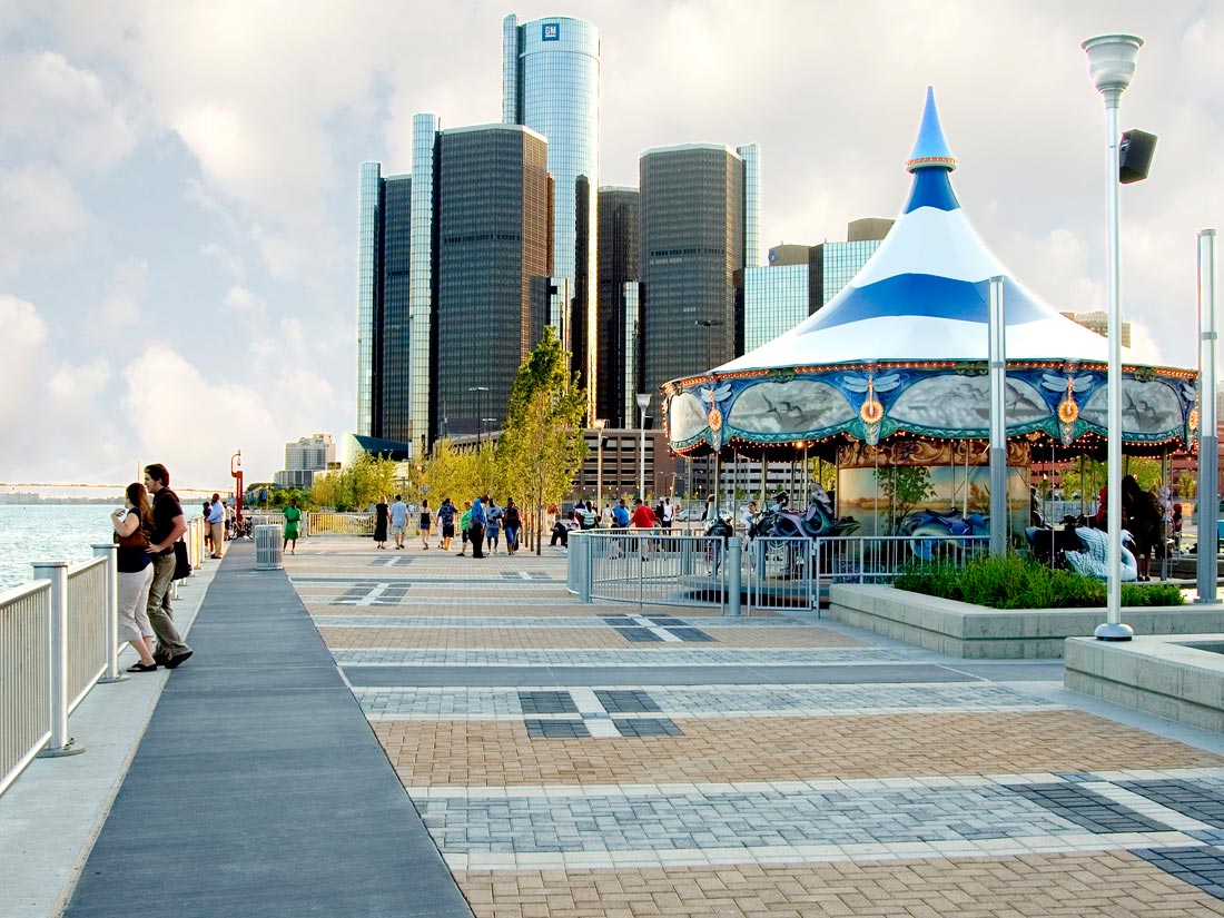
The goal is a continuous 5.5-mile RiverWalk between the MacArthur Bridge to Belle Isle and the Ambassador Bridge to Canada. Today, the East Riverfront portion is 90% complete and already has nearly 3 million annual visitors. Much like the effort to recreate front porches on houses in cities to encourage a sense of community, promote interaction with neighbors, improve security, and foster sustainable development, creation of the Detroit RiverWalk with riparian habitat and other ecological features can help recreate gathering places for both wildlife and people with many social, economic and environmental benefits.
Economists have quantified that in the first 10 years of the Detroit RiverWalk, there was an over $1 billion return on its initial $140 million investment, with the potential for an even greater return in the future. This provides compelling evidence of return on investment and shows that the riverfront has evolved beyond a physical asset and is now a community by itself and an asset to the city. If you have not seen it or visited the Detroit RiverWalk, you should see how it is welcoming to all people and experience it first-hand. Mark Wallace, President and Chief Executive Officer of the Detroit Riverfront Conservancy, notes:
“Without this early focus on cleaning up the river and improving water quality, this transformation of the river’s edge would not have been possible.”
You might ask why should I care about building the Detroit RiverWalk in Motown? One simple answer is that it is one of the largest, by scale, urban waterfront redevelopment projects in the United States and if such waterfront redevelopment can be done in Motown, including being the largest city in the United States to ever go through bankruptcy, it can be done elsewhere. A second answer has three parts:
· Cities are the creative engines that drive innovation and growth, and Detroit has demonstrated time and again that its creativity, innovation, and work ethic can impact the nation and world;
· It is an economic and political fact that we are all inextricably linked and that Detroit is an indispensable part of the American economy and culture; and
· Detroit has always been there to help meet the needs of the nation and world, and now Detroit needs the nation to help Detroit create the America for tomorrow: until we see a renaissance of Detroit, we cannot fully realize the American Dream.
A third answer is that it protects natural capital, improves quality of life, enhances competitive advantage, and helps develop the next generation of conservationists and sustainability entrepreneurs in urban areas, because that is now where 80% of all U.S. and Canadian people live.