The past few months have been a blessing to New York City map lovers: Cartography fiends can browse future skyscrapers, prepare for L-mageddon, and discover the city’s noisiest neighborhoods or hidden civil rights histories. Now, the New York Public Library (NYPL) has unveiled what could be—for history nerds, at least—the mother of all maps: The NYC Space/Time Directory, a “digital time-travel service” that combines the library’s map collection with geospatial tools to illuminate the city’s messy and beautiful development over more than a century.
")
Travel though space-time with a new map tool from the New York Public Library. (Courtesy NYPL)
The project’s first map takes 5,000 street maps from across the city and folds them into one interactive database that spans a century, from 1850–1950. Maps by Decade aggregates maps from the NYPL collection, an improvement on the library’s previous georectification tool, the Map Warper. The NYC Space/Time Directory, which includes more than 8,000 maps and 40,000 geo-referenced photos and counting, is supported by a grant from the Knight Foundation.
Ready to time travel? A click on The Architect’s Newspaper‘s home neighborhood of Tribeca shows six maps from 165 years ago. The user can transpose a ward map from 1852 onto present-day streets, or view the same map in the NYPL’s digital collections, or take the map for a spin in the Map Warper, below:
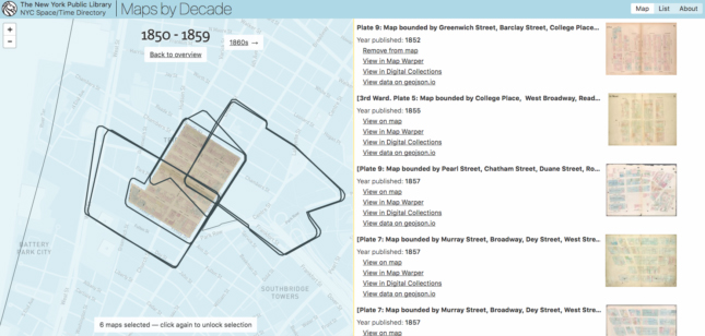
How cool is that? (Courtesy NYPL)
Better yet, the project is all open source. Users can access each map’s geospatial data, and the source code for Maps by Decade is on GitHub. For those who wish to collaborate on more mapping projects, Hyperallergic reports that NYPL’s Space/Time Directory Engineer Bert Spaan is organizing IRL meetups around the city to make more maps using the library’s resources.