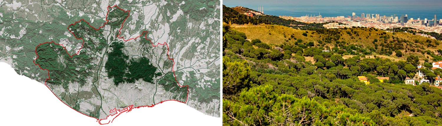
The Collserola mountain range is a singular natural area covering over 8,000 hectares at the heart of a complex metropolitan reality. It therefore has great potential in terms of providing ecosystem services on a metropolitan and regional level, yet little ecological continuity with other nearby open spaces. The creation of the Serra de Collserola Natural Park in 2010 gave rise to the current special protection plan, PEPNat, which aims to preserve biodiversity and increase ecosystem services under dynamic and adaptive management.
Serra de Collserola Natural Park and the Metropolitan Green Infrastructure
The metropolitan area of Barcelona covers an area of 636 km2, encompasses 36 municipalities with 3.2 million inhabitants, and provides 1.5 million jobs. Despite being a densely populated area with complex metropolitan dynamics, open spaces occupy 54.6% of the territory, the vast majority of which are protected (more than 90%).[1] In addition, within the set of natural and semi-natural spaces, 30 habitats – five of which are priority habitats – have been identified as habitats of European Community interest (HCI), and these occupy 28.4% of the metropolitan territory.[2]
The orography that shaped the land occupation also enabled the preservation of spaces of high ecosystem services value such as the Collserola range, the natural areas surrounding the Llobregat delta, the Garraf massif, the Ordal mountains, and the Marina mountain range. Most of these spaces conserve their forest coverage and are a key feature of the so-called metropolitan green infrastructure. At the same time, forest areas combine with farming activities to form an agroforestry mosaic.
The Serra de Collserola Natural Park is a unique area of over 8,000 hectares with significant ecological value, located in the heart of a complex metropolitan realm. The Park’s abrupt relief, compared to the surrounding flatter spaces, has preserved it from indistinct urban sprawl. Today, situated in the middle of a densely populated and congested area, the Park is a well-preserved biodiverse territory of farmland and forests with the potential to play a key role in the environmental and ecosystem balance of the metropolitan area.[3] Nevertheless, the metropolitan context of the Park could jeopardise the conservation of ecological values and biodiversity.[4] It is imperative to maintain ecological processes for conserving the biodiversity and functionality of the Collserola mountain range and improve the external and internal ecological connection.[5] Other key factors in maintaining the integrity and quality of the space are achieving a balance between disruptions coming from social use and the Park’s activities, and conserving ecological and cultural values.
The New Collserola Range Protection Plan (PEPNat)
PEPNat is a hybrid plan combining environmental and urban planning aspects. Its main goals are to con-serve biodiversity and boost ecosystem services within a framework of dynamic and adaptive management.
The new special protection plan, PEPNat, complies with Decree 146/2010, under which the Collserola Range was declared a Natural Park, and replaces PEPCo, the plan in force since 1987. PEPNat was drafted by the AMB within a framework of co-governance and very broad consensus, under the guidance of a technical and institutional commission formed by the Serra de Collserola Natural Park Consortium and the administrations involved (Government of Catalonia Barcelona Metropolitan Area (AMB), Barcelona Provincial Council, and the nine municipalities contained in the Park), and chaired by the Director General for Environmental Policies and Natural Environment of the Government of Catalonia.
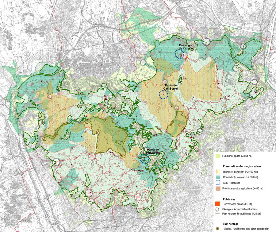
PEPNat covers an area of 8,156 hectares that also comprises the partial nature reserve of La Rierada – Can Balasc (383 ha) and La Font Groga (117 ha). Besides the land declared as Natural Park, PEPNat incorporates a functional space consisting of areas which, due to their characteristics or functionality, are funda-mental in attaining the objectives of protecting and improving the biodiversity of the Park. The total area of the functional space, which includes both interior and perimeter areas, is 3,676 hectares. The table below summarizes the topics that were taken into account to acknowledge the state of the Park during the drafting process and to define the main objectives of PEPNat. The analysis of these topics required a multidisciplinary team.

New Park Model
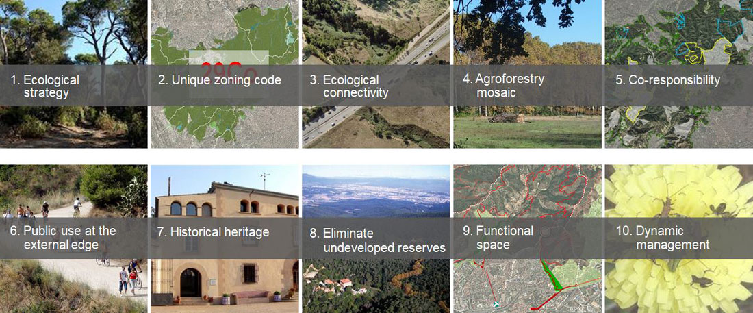
The ecological strategy is the guiding principle at the core of the new Park model. Proposals include the management and regulation of use and intensity of use of the Park, as well as guidelines, recommendations and strategic projects to be developed by the managing body. These proposals have been organised into six sections, within a framework of dynamic and adaptive management.
1. Preservation and enhancement of ecological values
The proposals within this section are situated along four axes: improvement of ecological connectivity, both internal and external to the Park; conservation of elements of ecological value; control of disturbances; and promotion of the green economy. These four axes are present in all the proposals included in the Plan. Within the general framework of a single, maximum protection zoning code (code 29CO), environmental zoning is established under the Plan. Thus, apart from the partial nature reserves declared under Decree 146/2010, PEPNat defines four areas that play a key role in the preservation of biodiversity and the enhancement of ecosystem services: patches of connectivity interest, areas of special importance, islands of tranquillity, and priority areas for agriculture. These areas are based on particular processes or functions of the Park and play a key role in management plans.
2. Valorisation of natural resources
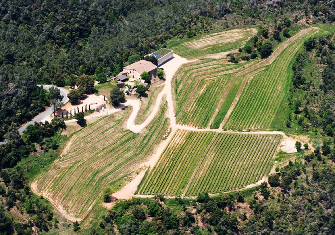
Forestry, agriculture and livestock stand out among the Park’s primary activities. Under PEPNat, all these activities are permitted – albeit with strong restrictions in the most sensitive areas – throughout the Park. One of the Plan’s main goals is to increase and restore agricultural land uses, given that the amount of cropland has dropped considerably over the last decades. Nevertheless, recent years have seen an increase in local demand for quality products and the number of people interested in becoming farmers.[6] This is also compatible with the goals of promoting the agroforestry mosaic and proper management of habitats and species.
Given this context, PEPNat encourages the establishment of synergies between the management body and the owners of agroforestry estates. More specifically, it facilitates sustainable agricultural activities and establishes a link between the permitted uses of existing traditional buildings and specific estate management. This management should also foster the agroforestry mosaic and safeguard the role played by patches as stepping stones for the improvement of habitat surface, quality and connectivity, among other aspects. In this way, PEPNat aims to promote primary sector activities from an ecological perspective, as well as rehabilitate and highlight the extant cultural heritage. The instrument employed to implement this co-responsibility formula is the Technical Estate Management Plan.
3. Public use
The Plan defines a basic network of paths and recreational and educational areas. In alignment with the objectives of PEPNat, and taking into account the existing infrastructure for public use, this network prioritises the reduction of social pressure in sensitive areas inside the Park, access to the Park by non-motorised means, and the relationship between the Park and other metropolitan open spaces.
The Plan takes advantage of existing infrastructure for public use (paths, recreational areas and public facilities) on the one hand, while creating islands of tranquillity on the other. These islands are produced by identifying the least disturbed areas, mainly in relation to social use of the Park and any other element or activity that creates disturbances in ecosystems and their functionality. They are spaces that require favourable conditions for flora and fauna, and receive differential treatment. Hence, access is expected to be more restricted in these islands, and possible disturbances are subject to specific conditions.
4. Built heritage
The proposals related to built heritage have two key objectives: to rehabilitate and highlight the value of local remaining cultural heritage, and to prohibit new construction (with a few exceptions related to primary activities and park management). To achieve these objectives, a number of constructions have been listed in the catalogue of masies (gable-roofed rural constructions common to the east of Spain), rural homes and other constructions (199 in total) which are the product of the traditional, sustainable colonisation of the territory, and respect the characteristics of local agriculture and the natural landscape.[7]
The aim of the catalogue is to regulate the maintenance of the Park’s architectural, historical and cultural heritage and its permitted uses in a way that is beneficial to the Park, the intention being to introduce uses that strengthen the protection of Collserola’s ecological and cultural values. Family homes, artistic and professional activities, rural tourism, restaurants and public facilities are the uses permitted.[8]
One key aspect is the link between the re-use of buildings and estate management, whereby private owners can contribute to the preservation of the ecological assets of the Park through a public-private estate management formula. These uses could have other effects. They should help to establish a population with strong ties to the Park, return to a well-kept heritage, and stimulate the revitalisation of the territory by offering related complementary activities.
5. Infrastructures and technical services
The main objectives are to minimise the occupation and fragmentation of open spaces, improve the per-meability of infrastructures and establish conditions for the maintenance, improvement or enhancement of existing infrastructures.
Regarding existing planned areas, PEPNat adapts planning to reality, eliminates non-developed areas, and changes the road zoning code of simple paths, among other specific proposals related to infrastructures and technical services. Likewise, the Plan distinguishes between infrastructures that serve the Natural Park and other larger-scale infrastructures that merely traverse the protected space, which under PEPNat require an environmental assessment and integration measures.
6. Functional space adjacent to PEPNat
The functional space includes areas outside the Natural Park whose characteristics or functionality enable them to make a decisive contribution to the conservation of the Park’s values and the processes that take place inside it. Correct organisation and management of these spaces is likely to establish synergies with the Natural Park. PEPNat defines both guidelines and recommendations, and includes a catalogue of good practices within this functional space. These guidelines and recommendations refer to ecological connectivity, the ecological values of edge spaces, fire and other natural risks, accessibility, social use, and the transition between the Park and urban fabrics and buildings located on the perimeter.
Implementation and Monitoring of the Plan: Dynamic and Adaptive Management
In line with its ecological strategy, the implementation of the Plan is committed to dynamic and adaptive management. In this regard, the main proposals are the environmental zoning strategy, and monitoring of the state of the Park. Besides the partial nature reserves defined under Decree 146/2010, PEPNat defines four areas that play a key role in the preservation of biodiversity and the enhancement of ecosystem services (see Section 1, “Preservation and enhancement of ecological values”). These areas contribute to the adaptive management of the Park in three ways. In the first place, they have been defined according to their functionality rather than their appearance or degree of “naturalness”. Secondly, not only are these areas subject to greater monitoring, they have also served to define the first set of indicators. And finally, with the exception of the partial nature reserves, the delimitation of these zones can be more easily adjusted than under the previous plan (PEPCo).
Monitoring of the Park’s values and compliance with PEPNat’s environmental objectives will be carried out in different phases and scales. Environmental monitoring has been carried out continuously, through-out the strategic environmental assessment and the drafting of the Plan, while monitoring during the implementation phase has been planned at three different levels, based on environmental indicators and the Multicriteria Tool. PEPNat’s seventeen indicators are related to the environmental objectives and have been grouped into four thematic areas: biodiversity, ecosystem services and landscape, disturbances, and education and dissemination. A GIS-based Multicriteria Tool has also been planned to monitor the state of the Park.
Innovative Aspects
Perhaps the most important innovation of the Plan is the paradigm shift it embodies. PEPNat introduces a new vision for the protection of natural spaces that is particularly ground-breaking from an urban planning perspective. Unlike the previous model, which was based on a still photo of particular landscape types and units and responded to the characteristics of the vegetation and the territory at the time the Plan was drafted, PEPNat recognises the processes and functions that take place within the Park and beyond. Besides this fundamental change in understanding the protection of natural spaces, other significant innovative aspects of the Plan are worthy of note, as summarised in the headlines below.