The Brooklyn waterfront is continually evolving. What was once a soft shoreline of wetlands, marshes, shallows, beaches and tidal flats is now a series of elevated piers, bulkheads and physical barriers, compromising the relationship between water and city. Inspired by the opportunity to create a living waterfront, BIG’s River Street Waterfront Master Plan vision, in collaboration with Two Trees Management and James Corner Field Operations, seeks to enhance the connectivity of the public waterfront, restore natural habitats, elevate the standard for urban waterfront resiliency and transform the way New Yorkers interact with the East River.


By deconstructing and re-naturalizing the built urban shoreline, the water’s edge is expanded into the city, creating a beach that brings people out to the water. A circular path frames a protected cove, providing 360° panoramic views of Brooklyn and Manhattan. By extending landscape-piers to the concrete caissons existing today, breakwaters are created that dissipate wave action from river waves and wakes from boats. This protected cove will support in-water recreation such as swimming and boating, while mitigating the effects of storm surge on the neighborhood.


The expanded and enhanced shoreline creates six acres of new park space (including three acres of in-water programming), featuring an outdoor tidal classroom, tidal pools, picnic and hammock grove, and a nature walk. Habitat restoration addresses the biodiversity gap on the East River and builds off other initiatives in the region. This encourages the return of wildlife to the East River, which we are already beginning to see today.


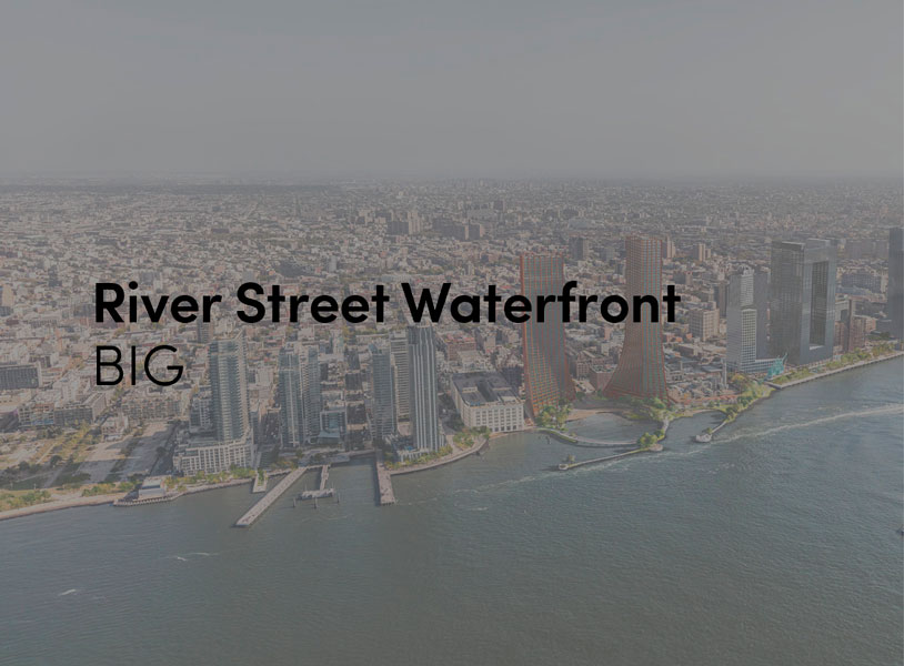
The building footprint results from expanding the public realm, significantly increasing public park space while minimizing the building area at the ground level. Framing the new park are public-facing programs: a new 47,000 sf YMCA, 30,000 sf of neighborhood-oriented retail space and 4,500 sf of community occupied kiosks. The remainder of the two mixed-income buildings will provide 1,000 total units of housing, 250 of which will be below market rate. The residential towers are oriented to limit view obstruction from the neighborhood and maximize the Metropolitan Avenue view corridor. Blending the towers with the landscape softens the relationship between building and park, forming a gateway that welcomes the community to the water.


“Our proposal closes one of the last remaining gaps in the continuous transformation of the Williamsburg waterfront into a post-industrial natural habitat. Rather than stopping at the hard edge of the old dock, Metropolitan avenue is split into a pedestrian loop extending all the way in to the river, connecting the dots of the concrete caissons to form an urban archipelago of recreative islands while protecting a beach and body of water for water sports and wetlands. The radical transformation of Copenhagen’s port into a swimmable extension of the public space that we helped pioneer two decades ago, now seems to be knocking at the door in Williamsburg and the entire East River. The River Loop will be the first of many invitations for New Yorkers to dip their toes in the water.” Bjarke Ingels, Founding Partner & Creative Director.


“We investigated the opportunity to stretch the Williamsburg waterfront landward with a circular pier and protected cove for water-based activities, inviting New Yorkers to take back and enjoy the river as a social and ecological public amenity. Surrounded by a necklace of recreation, educational and commercial programs, we envision the historic piers to be renewed and teeming with life. The masterplan proposes splitting Metropolitan Avenue into two diagonal pathways that connect to the waterfront promenade, resulting in triangular building footprints with views to the East River. Two towers inspired by Williamsburg warehouses are injected with neighborhood-oriented retail at its base, while the traditional podium is replaced by cascading terraces that frame and soften the relationship to the park.” Daniel Sundlin, Partner, BIG.