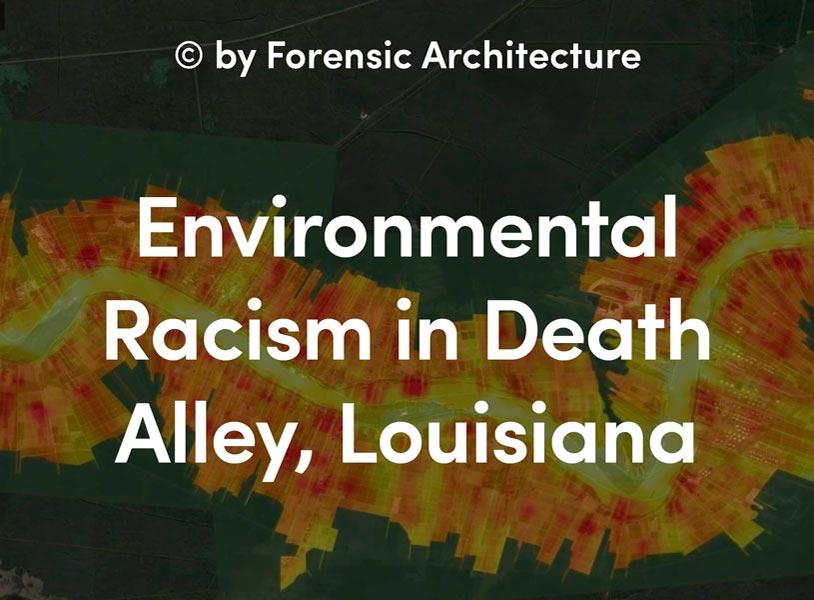
A stretch of the Mississippi River once called ‘Plantation Country’ is now the ‘Petrochemical Corridor’, known to those who breathe its toxic air as ‘Death Alley’. Using advanced techniques in cartography and fluid dynamics, the latest investigation by Forensic Architecture (FA) supports ongoing and future action against further industrial expansion by local community activists RISE St. James and other groups of local activists across the region.

EPA levels
Sites of PM2.5-producing facilities are layered onto a ‘heat map’ showing concentrations of PM2.5 (particulate matter) in the atmosphere, according to a 2020 survey by the EPA.

Inconsistent cemetery marking samples
While a few cemeteries are mapped, the majority are omitted and the symbology of mapped cemeteries is inconsistent. Multiple verification practices are required to get closer to confirming the locations of cemeteries.
The case
In the US state of Louisiana, along the Mississippi River between Baton Rouge and New Orleans, a heavily industrialized ‘Petrochemical Corridor’ overlays a territory formerly known as ‘Plantation Country’. When slavery was abolished in 1865, hundreds of sugarcane plantations lined both sides of the lower Mississippi River; today, more than 200 of them are occupied by some of the US’ most polluting petrochemical facilities.

Industrial Expansion
Multiple layers of public data reveal the ongoing sell-off of land along Death Alley, including residential land that is home to ‘fenceline’ communities.

Anomalies map
Forensic Architecture identified more than a thousand ‘topographical anomalies’ throughout Death Alley, many of which could be cemeteries.
Residents of the majority-Black communities that border these plants breathe some of the most toxic air in the country, and suffer some of the highest rates of cancer and COVID-19 mortality, along with other serious health ailments. They call their homeland ‘Death Alley’.

Anomalies – 1940
1940 aerial imagery from USDA capturing ‘topological anomalies’ in the former Houmas, Union, Orange Grove, and Burnside plantations. Some anomalies are revealed to be ruins of former plantation facilities (black), while some are revealed as sacred groves (red).

Anomalies – Whitney
Anomalies identified on the site of the former Whitney Plantation line up closely with the predictions of our ‘field of probability’. (Forensic Architecture)

Mosaic 1961 USGS
An example of Forensic Architecture’s ‘mosaic’ cartographic technique; multiple images from 1961, property of the US Geological Survey, are stitched together to recreate an area of Death Alley. (Forensic Architecture / USGS)
A new investigation
Death Alley contains hundreds, if not thousands, of cemeteries of enslaved people, the vast majority of which are uncharted, and seemingly lost. But the presence of a cemetery can put a stop to proposed development, rolling back the advancing occupation of the region by industrial expansion. FA studied over fifty archaeological field reports commissioned by industry across the region, identifying a systemic disregard for the cemeteries of enslaved people.

Chart no. 72
Chart titled “Survey of the Mississippi River, Chart no. 72” from the MRC 1894 series, partially covering St. James and St. John Baptist Parishes. (Missouri River Commission)

Sheet no. 12
Sheet no. 12, titled “Mississippi River, Louisiana, from Chapman Plantation to Brilliant Point,” from the USCS 1878 series. (US Coast Survey)
FA’s investigation uses fluid dynamics simulations (provided by collaborators at Imperial College London) to evidence the spread of toxic air pollutants across Death Alley, and proposes a new methodology for estimating the probable locations of cemeteries, drawing on maps and aerial imagery, an analysis of the spatial and economic logics of the plantations, rates of forest clearance, and other historical factors to create ‘fields of probability’ which can contribute to the efforts of the descendant community to recover lost ancestral sites.

Concentration map 23 May 2020
Using fluid dynamics simulations provided by researchers at Imperial College London, Forensic Architecture estimated average concentrations of the pollutant PM2.5 in Death Alley on 23 May 2020.

1940 USDA on 2021 Google Earth
The earliest aerial images available of the Death Alley region, from the US Department of Agriculture, overlaid on Google Earth imagery from 2021.

Plantation reconstruction
Based on historical research, maps, and archival images from the Historic New Orleans Collection, FA reconstructed a ‘typical’ plantation in 3D, in order to explore the operational logic of the plantation economy.
The Black descendent community has long voiced demands for accountability from the petrochemical corporations that occupy their lands. Our research will be open sourced and made available to the public, to support local claims for accountability and reparations.

Probability Field
By combining multiple factors, including analysis of plantation spatial logics and distances from the riverfront and the forest line, FA created a ‘field of probability’ that predicts the likely locations of cemeteries across Death Alley.

Probability Field
By combining multiple factors, including analysis of plantation spatial logics and distances from the riverfront and the forest line, FA created a ‘field of probability’ that predicts the likely locations of cemeteries across Death Alley.