If creating public space in spontaneous settlements were embraced as an effective investment to increase social inclusion and better integrate Latin American cities, how much would have to be built? Quantifying this endeavor and defining a target scope would help optimize resource allocation and public policy. To begin with, public spaces are not as prevalent in Latin American cities as they are in other latitudes of the world. Because of their scarcity, the few that do exist are often heavily overused, and their deterioration exceeds maintenance budgets. Others are almost completely overlooked by people due to their lack of upkeep and poor integration with the surroundings. Urban growth in Latin American cities during the 20th century occurred at an accelerated pace, with little or no regard for planning. Public space was not considered essential and even deemed undesirable since unattended space risked being illegally occupied with informal housing. When compared to economically developable property, public space appeared to be an inefficient use of land.[1] The scarcity of public space means that people have few experiences or memories in them and therefore their relationship to parks and plazas is very tenuous. They are seldom perceived as important urban cultural elements.
Land in the public domain is often public precisely because it could not be used for other purposes, either because it was inappropriate for urbanization or considered too environmentally sensitive. Other undefined remnants of space, such as areas surrounding infrastructure and waterways, sites with adverse topography or residual spaces, are frequently fenced off and rendered “black holes” in the city. Transforming them into well connected, adequate public spaces remains challenging at best and a far cry from the ideal extension of areas for recreation and leisure cities should offer. Over the past two decades, cities in Latin America have gained awareness about the fact that public space is the only urban land use where all social classes are welcome.[2] Furthermore, statistics show that access to well-conditioned public space increases trust among social groups and improves personal safety.[3]
Cities in Latin America, however, are notorious for having low public space indexes: 1.1m2 per inhabitant in Caracas; 3.64 m2 in Medellin, and 3.7 m2 in Santiago de Chile.[4] As a standard, sources will often cite 10 m2 per inhabitant to reference a desired amount of public space.[5]
Very few Latin American cities find themselves in this range, the exceptions being Quito which provides its citizens with 17.8 m2 per inhabitant and Curitiba, which boasts 64.5 m2 per person. [6] And yet, even when cities are fortunate enough to count on sufficient public space, it may not be accessible to all parts of the city. We find that the supply of public space is not uniformly distributed: it is often much closer to people living in “formal” areas of the city than to those living in “informal” ones. For example, a study conducted in 2013, revealed that in the entire territory of Petare, which is the largest spontaneous settlement in Caracas, there was scarcely 0.1 m2 of public space per inhabitant, while the rest to the city has 1.1 m2 per capita. [7] In other words, the supply of public space in Petare is ten times less than that of the rest of the city and 100 times less than the theoretically ideal amount. With a total population of 218,048 [8] living in a fairly dense informal urban environment, increasing the per capita amount of public space to meet the standard offered in the rest of the city would require approximately 196.243 m2 or 20 hectares of new conditioned public space, which represents 4.0% of the settlements 709 hectares.
Coming to terms with the amount of public space needed is crucial, as it reveals the urgency in developing innovative and unconventional methods of space production that can overcome the challenge of creating open space where none exists. Spontaneous settlements have very different urban conditions which require alternative spatial approaches to the issue of public space. The location, size and distance of a settlement from urban centers also affect how dense it becomes. For example, well located informal communities that enjoy better access to services, and are ostensibly better integrated with the rest of the city, tend to become denser. On the contrary, those located in the periphery, where access to services is poor, tend to remain less dense.
Determining the scale and type of public space making strategy is therefore contingent upon the physical and social conditions of the settlement. Smaller spontaneous settlements, nestled within planned urban areas, benefit from the services and public spaces offered by the rest of the city. In these neighborhoods, smaller insertions of benches, plazas and children playgrounds would already represent a significant contribution to everyday life for their residents and would not require large investments. For activities that require more space such as playing basketball, strolling, or riding bicycles, people would use public facilities and parks in nearby neighborhoods, supporting a healthy exchange of space among communities. When considering larger settlements, however, often located in the city’s outskirts and those with areas above 50 hectares, more ambitious and creative strategies are required.
Spontaneous settlement inhabitants tend to have limited experience with public space and see it as an obscure destination in the city or at best as an optional amenity. Hence, identifying the value it could bring to their own community remains part of the challenge to overcome. A starting point could be to identify and upgrade existing common spaces. Such improvements would require modest resources, and would not be met with opposition, since the spaces are already recognized by the community as public. This could help increase peoples interest in public spaces and convince skeptics that they are desirable and beneficial to the community. However, rescuing existing spaces alone is not enough to offset the severe public space deficit. It is not just a matter of doubling or tripling the present amount of public space. As indicated earlier in the statistics from Caracas, the deficit requires a ten fold increase. In the specific case of Petare Sur, the settlement extends over an area of 484 hectares and houses a population of 129.920 inhabitants.[9] The current stock of potential public spaces scarcely amounts to 9,413 m2 or 9.4 hectares. (Fig. 1) If Petare Sur were to reach the standard of public space offering of the formally disposed areas of the city, it would have to provide 129.920 m2 of public space, i.e. one square meter per inhabitant; and 120,507 m2 or 12.0 hectares of new parks and playgrounds would have to be built. In other words, in the case of Petare Sur, public space should be increased by a factor of twelve. Along the same lines, spontaneous settlements with dense populations of 300.000 or more inhabitants would need to produce 30 hectares of public space in order to offer at least 1 m2 per person.
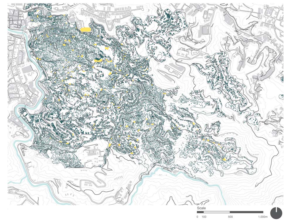
Fig. 1 Plan of Petare Sur, Caracas Venezuela maps existing public spaces or common areas in the barrio. They only add up to 0.94 hectares.
One approach that has already been used to produce large new extensions of public space has been to conflate the construction of parks, paths and walkways with the relocation of people living in high risk conditions in order to increase resilience against natural disasters. The removal of structurally unsound homes built over landfills, running creeks, or floodable land along the edges of waterways, can become an opportunity to convert the emptied site into recreational areas. On one hand, it ensures new settlers will not build homes there again, and on the other creates public space. Medellin and Guayaquil for example, have implemented projects along these lines; however, it is important to note those projects are socially complex and costly. Relocating families means covering the expense of new homes, overcoming the emotional hardship of moving, and slowly recovering the environmental conditions of the previously occupied land.
Since 2000, Guayaquil has been progressively creating a linear park that extends over several dozen kilometers along the Estero Salado, which is an estuary or saltwater canal. Much of the rivers edges were once invaded with self-built homes over precarious foundations of debris thrown into the estuary to gain land from the water. The mangroves that once lined the estero and maintained a lush animal habitat had disappeared and, in their wake, left a forgotten landscape, polluted with sewage and chemical waste, where scarcely any aquatic life remained. Since the risk factor associated with the built homes was high, given their unstable foundations, a municipal project was designed to address their relocation and properly channel sewage water away from the estero. The initiative also created an opportunity to restore natural habitat, increase urban resilience and create new public space in the form of a raised walkway along the water edge. The Estero Salado has become progressively cleaner. The linear park allows access to the river which in turn gives neighbors the opportunity to keep watch over what is released into the water, a way of policing themselves for improper waste and sewage disposal. It also helps prevent the construction of future illegal homes. Over time, the segments of linear parks have been connected into a vast network of bicycle paths and walkways that are used not only by neighbors, but also by Guayaquil citizens at large, thereby integrating the city along the river edge. This new park system is also partly responsible for the city’s increase in public space per capita from 1.0 m2 to 7.9 m2. Water sports such as rowing, are regularly practiced and the mangroves have returned along with renewed animal life.
The Moravia Ecological Park in Medellin has transformed a landfill into 45.18 hectares of public park. It was once the city’s waste dump. Waste pickers rummaged the open-air dump and lived off of the material they selected and sold to recycling operations. The settlement slowly emerged as the waste-pickers built shacks and homes on site. Over time, it grew and spread across 45 hectares of wasteland, with a population of 37.000.[10] Since waste decomposes and is a very unstable ground for construction, the foundations of homes could collapse at any time. Additionally, gases and bacteria exposed inhabitants to grave health risks. The municipality in conjunction with the community formulated a project to relocate homes away from the landfill into new buildings in nearby sites and neighborhoods. The landfill was closed and a project to transform it into a park with playgrounds, planting and open space was designed. Beginning in 2004, the waste dump was progressively converted into an “ecological park.” Approximately 4.000 houses built over the landfill were razed. Negotiations with each family required different agendas and agreements. 140 houses still remain with families that have resisted relocation, but in every other respect, the 9.8 hectares (98,593.95 m2) of landfill have been converted into a public park over a period of 13 years. Productive vegetable and flower gardens, paths, benches, light posts and pavement have created a lively environment for neighbors. There are also two upcycled structures, a bus and a container, that serve as activity spaces and programmatic extensions of the nearby Moravia Cultural Center. Further east, the park is formally connected to the Cultural Center via the creek that has been transformed into a linear boulevard. This makes the park easily accessible not only to Moravia inhabitants but to visitors and tourists as well. Furthermore, the park is adjacent to the Medellin River, where an ambitious urban renewal project to transform the entire riverside into a linear park has been developed.[11] This will connect Moravia to a metropolitan park system and allow citizens from other areas of Medellin to have direct access to Moravia’s public spaces. A network of open and accessible parks weaves its way through the city, allowing people to flow freely from one area to the next.
Another large-scale example of public space creation in spontaneous settlements occurs in Chapéu Mangueira – Babilônia in Rio de Janeiro. The carioca case, however, is not related to risk management, but to environmental preservation. Chapéu Mangueira and Babilônia are nestled on the skirts of a very steep hill or morro that defines the northern end of the Copacabana Bay. Once completely deforested, the morro is today covered with lush tropical vegetation due to the organized efforts of the community to reforest the land. They created a network of paths between the settlement and the mountaintop in order to survey and tend to the vegetation they planted. The natural reserve´s recovery helps produce cleaner air, generates oxygen and creates a comfortable microclimate for inhabitants. It also serves the community with places for recreation and has become closely associated with its local identity. The forest offers the city 22 hectares (220,909 m2) of a natural reserve that represents an urban amenity and destination at the metropolitan scale. It not only increases access for locals to public space, but also invites outside visitors to use and enjoy the park. Neighbors of Chapéu Mangueira and Babilônia work as guides and welcome guests through the favela into the forest. The communities become integrated with the city through a continuous experiencethat minimizes the perception of boundaries.
Most spontaneous settlements, however, will need to consider a combination of projects, in order to produce the amount of public space required. Diverse, flexible and practical approaches are needed to take on the challenge of reversing structural differences in urban territories. If we look at Petare Sur as an example, strategies will have to include the recovery of existing spaces, which entails little investment, as well as the addition of large new areas, which involves greater social and financial cost. Both are necessary to reach a more appropriate allocation of public space in spontaneous settlements.
An example of the first approach, intervening existing open spaces, occurred in the neighborhood of La Ceiba in Petare Sur in 2017. A 750 m2 area, functioning as a de facto public space, was the result of a channeled, covered creek, accessible on its lower side from a roadway; along its upper edge two stairways connect to neighborhoods beyond. A provisional basketball court was drawn onto the concrete slab on the upper half of the space, and privately-operated jeeps used for public transportation occupy the lower half of a de facto terminal for passengers. The initiative to transform this space into a more active public plaza, was part of an urban program financed by Citibank and coordinated by Fudep Venezuela. Enlace Arquitectura was brought on board to lead the design process together with the community. Between January and June 2018, the space was completely transformed into an operable public space with several programmatic areas geared toward different age groups. Today it is intensively used by the community and has significantly contributed to the livelihood of neighbors.(Fig 2) Furthermore, the project required modest funding and represents a viable method to create new public spaces within existing urban conditions. The map of (Fig. 1) shows available spaces that could also be considered for projects similar to the one in La Ceiba.

Fig 2. View of the public space Project Plaza Santa Rita in La Ceiba, Barrio Unión, Petare Sur. The project was part of the program City Planting – Fudep, designed by Enlace Arquitectura 2017.
A second approach is to take advantage of places currently used to dump waste. Individuals are not claiming them as private property which means that they are implicitly understood as places for common use, albeit for waste. Over the past year, neighbors of various sectors in Petare Sur have initiated campaigns to eliminate waste dumps and convert them into clean, well-kept areas, often painting murals, incorporating basketball hoops or planting vegetation.[12] Small pockets of space are useful and necessary to create a continuous and well-balanced offering of plazas and rest areas. Places such as the covered creak, in La Ceiba, and improvised waste dumps are frequent in Petare. In order to transform them into public spaces, they would need to be systematically subjected to community design processes, where subsequent maintenance plans are also taken into consideration. Approximately 167 public spaces such as the one in La Ceiba would have to be built to satisfy the current public space deficit of 12.5 hectares. The reality, however, is that there is not enough open space available for public space; so other approaches are necessary.
For example, the Guaire River, which runs along Petare Sur´s southern border, could potentially be considered an asset instead of a disadvantage, as it is currently perceived since it is an open-sewage channel that runs through the city. The community La Linea is the settlement in Petare that immediately fronts onto the river edge. During the rainy season, it is periodically threatened by floods. Land is not fit for habitation and proper risk management of this informally developed area requires structured, long-term solutions. As both a way of mitigating flood threats and creating new public space for Petare Sur, inhabitants living in portions of this neighborhood would need to be relocated, their homes razed, and the unoccupied land transformed into a floodable linear park. This would allow the terrain to absorb the river´s natural water level changes without harming inhabitants. It would also provide residents with ample open space they could use for leisure and recreation most of the year. Up to 41.159 m2 or 4 hectares of new public space, the equivalent of 33% of the space needed to level differences between planned and unplanned urban areas, could be created for the benefit of nearby communities along the river edge. Another advantage is that it would represent a segment of a larger public space project along the river, which could potentially traverse the entire city increasing accessibility, facilitating alternative mobility options and connecting several spontaneous settlements, including Petare, with the rest of the city. (Fig 3)
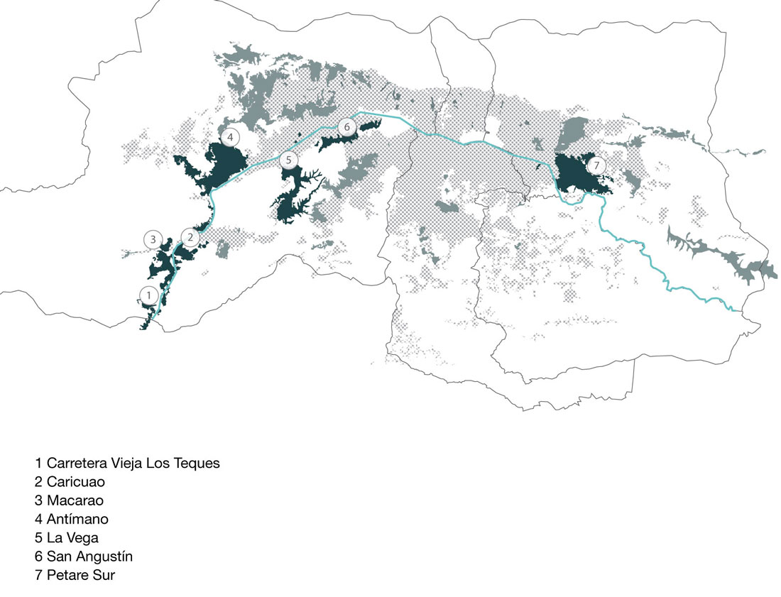
Fig. 3. Plan of the Guaire River and the potential linear public space along its edges. It could represent an area of 128 hectares.
The need for public space in spontaneous settlements requires creative and less obvious approaches, that extend beyond rescuing existing plazas and transforming left over spaces into pocket squares. Communities residing in the city´s periphery, which are particularly underserved by services and amenities, will require multiple, simultaneous and widespread approaches to mitigate their lack of public space. Strategies such as the Moravia Ecological Park, the Estero Salado linear park and the Chapéu Mangueira – Babilônia natural reserve are particularly valuable examples of creative and effective ways to reduce local public space deficits.