aldayjover designed one of the first floodable public spaces and public facility in modern times in Zuera Spain in 1998 – construction finished in 2001. The project, with a total extension of 20 Ha (50 acres), sealed a landfill and reconnected the river forest with the town. It included a bullfight and multi-purpose arena integrated in the park, compatible with seasonal floods. Its flood diagram became a paradigmatic image and the project was exhibited in the 2004 Rotterdam Architecture Biennale. With the title “The Flood”, it was meant to foster a national discussion in preparation for the Dutch operation “Room for the River” (2008-2014). This biennale confronted the public with increasing flood risks, seeking to visualize alternative solutions to traditional hard engineering operations.
In 2004, the Recovery of the River Banks of the Gállego River in Zuera was the only built project exhibited at the biennale as example of new solutions.
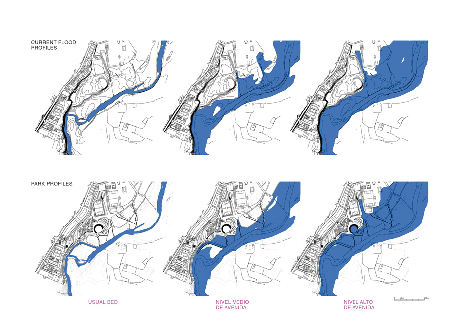
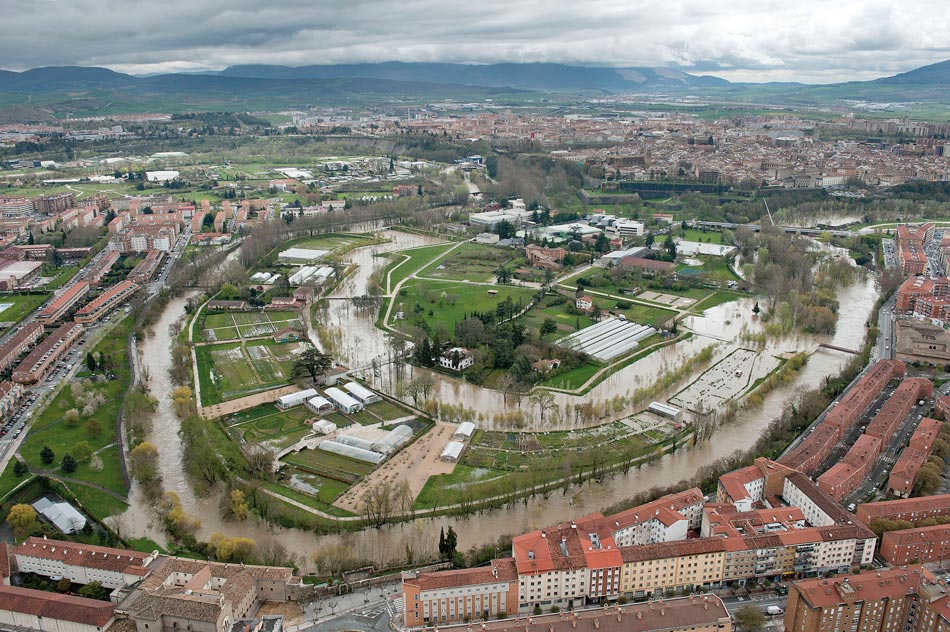
Recovery of the Gállego River banks in Zuera.
Flood diagrams
Before Zuera, only three public space projects had explicitly dealt with river or stream floods. In 1989 Pascal Hannetel designed a series of retention spaces in a small stream, the Petit Gironde.[1][2] Placed in a rural area, the design offered spatial qualities that announced its potential as a hybrid public space. The same landscape architect designed the Parc Corbiere (1995) in the floodable banks of the Seine in Le Pecq. As described by Prominski and his co-authors, the park engages playfully with the flood “but the use of the flood dynamics has not been extended to the design of the riverside”.[3] In 1993, Michael Van Valkenburg designed a radical proposal for the 32 acres (13 Ha) Mill Race Park in Columbus, Indiana (USA), allowing the free entrance of the river and keeping part of the civic program protected through topographical operations. The Recovery of the Gállego Riverbanks in Zuera took these precedents, most significantly the Petit Gironde, to “design the flood” in the public space with a radical new approach to the relation between rivers – and their dynamics – and their cities settled in the banks. The Gállego riverbanks project introduces the full scope of the flood dynamics in riverside public space and the bullfight arena.
This set of four seminal projects brings to the Western hemisphere in the turn of the XXI century the long tradition of the South Asian ghats, the stepped riverbanks, typically built with stone, that connect towns and temples with their rivers, mostly for cultural and religious practices but also for daily life (fishing, transportation, bathing, laundry, or leisure). South Asian Ghats negotiate the strong oscillations of the monsoon rivers allowing permanent access to the water through a strict architectural device. Ghats are physical connections between the urban terrace and the river flow, built in the same materials as the temples, forts and other urban constructions, as the Ahilya Fort in Maheswar, in the banks of the Narmada River. Ghats accept the water oscillation and capture copious sediments left by the river for its use in the fields, managing productively most of the effects of flooding.
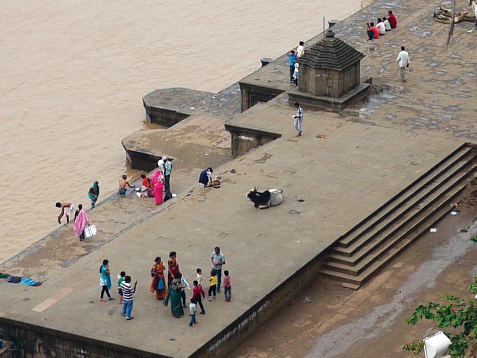
Ahilya Fort on the Narmada River, Maheswar, India.
Ghats details. Source: Pankaj Vir Gupta
Hannetel’s Petit Gironde, in a rural area, and aldayjover’s Gállego, in an urban area, reinterpret in their respective contexts the flooding of a stream (Petit Girond) or a small river (Gállego) including the rest of the river dynamics.
The Recovery of the Gállego River banks designs the sedimentation process with different planting strategies, filtering dragged objects and large solids, while allowing fine particles to pass for fertilization and flora development. A perpendicular drainage system is traced along the vegetal filters, including small bridges from which kids fish during the high waters season. Close to the concept of Ghats, the bullfight arena is a stepped amphitheater open to the riverbank that floods and drains through the two ceremonial doors -the matador’s and the bulls’ doors. The cattle areas are slightly depressed and become temporary ponds contained by walls, until the soil soaks the remains of the flood. The project was awarded with a groundbreaking European Urban Public Space Prize in 2002.
The later “Room for the River” (2008-14) was framed as a territorial operation at a big scale, fundamentally addressing farmland and rural or sub-rural areas, to increase the drainage capacity of the Rhine system in the deltaic lands of the Netherlands. With a complementary but different approach, the work of aldayjover focuses on the relation of rivers and floods with urban and peri-urban public spaces.
In 2005, aldayjover won the international competition for the Water Park for the EXPO 2008 “Water and Sustainable Development” in Zaragoza. It is located in the main river of the same watershed as the Gállego, the Ebro, the river that carries the largest volumes of water and with the highest seasonal variations in the Iberian Peninsula. This project is significantly larger, from 20 to 125 Ha (50 to 300 acres), transforming a peri-urban agricultural meander in decadence into the largest park of the city and the main piece of the 2008 International Exhibition. A quarter of the park is seasonally shared by the river and the citizens. This portion is occupied by a riparian forest crisscrossed by pedestrian and bicycle paths that are carefully kept away from the most delicate areas of the riverside. Former gravel extraction areas, later filled with trash, are recovered as infiltration wetlands for the drainage of the park’s canals and lagoons. Connected by canals that act as river flood and drainage channels, the natural floods physically reshape them and reinvigorate their performance as biotopes. The original farmers embankment, now a main public path, separates the seasonal floodable area from the rest of the park, protected from most high waters from the main river course but assuming the underground water floods that happen in parallel. The Water Park, Zaragoza floods on June 4, 2008, 10 days before the opening ceremony of the International Exhibition.
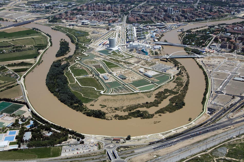
The Water Park, Zaragoza. Flood June 4, 2008, ten days before the inauguration.
In the Water Park, the buildings share the same design principles. They deal with the floods through different strategies. The bath, rowing and celebration pavilions adapt through lightness and permeability, with facades that allow water to enter while filtering solids and objects. The Arbolé Theater, however, engages the floods as a vessel with a concrete shell, anchored through its foundations. When the river swells, the waters outside arrive up to four meters (13 ft) above the lower row of seats. During floods, doors close as floodgates while internal drainages collect potential leaks and carry them to a low pumping point, securing that no water shows up in any portion of the theater. Published and awarded internationally since before its opening in 2008, the Water Park was followed by the Aranzadi Park in Pamplona, designed between 2008 and 2011, with its first phase finished in 2013.
The Aranzadi Park is the third in the sequence of floodable public spaces designed by aldayjover between 1998 and 2013. In Zuera and Zaragoza, the design strategies used the river banks to create a shared space for the river and the citizens. These meant the repositioning of embankments and paths, the adjustment of topography, the creation of areas for ecosystem development and social engagement, and the tracing of filters, flooding channels and drainage lines. In Aranzadi, the fringe along the river had been raised during centuries through agricultural practices that had become a valuable cultural heritage, including an endemic variety of lettuce – the Crispilla. The severely confined Arga River periodically burst its banks, flooding crops and farms on one side and neighborhoods on the other. During the last decade, the access to the meander had been blocked by new construction and part of the vegetable gardens had been abandoned.
The project assumed the challenge of maintaining the land’s original agricultural use, now with a social orientation, and of introducing people and public space, making the park part of the larger system of green spaces of Pamplona and of the territorial river corridor. The project also assumed the challenge of introducing a third user – the river – with space for its expansion, reducing the flood in the rest of the meander and, most importantly, in the neighborhoods of the opposite bank. The strategy here was radically innovative for an urban space. A floodable forest, excavated along a sequence of carefully selected plots, created a sunk public space that is used seasonally by the river as an additional channel. This space performs socially through playgrounds, picnic areas, a lawn for events and strolling paths for most of the year. For a few days every spring or fall, however, the river takes over and uses it as temporary branch. Once waters go down, a system of wetlands situated along the forest drains the remains. Given that the forest also collects all the rain runoff from the meander (nothing is pumped to the municipal network or sent directly to the river), the wetlands are permanent biotopes for flora and fauna, interspersed among the social programs.
Still, even after the public emergence of Zuera in 2001, the Aranzadi Park was the only project dealing with flooding and climate change at the 2014 International Landscape Architecture Biennale, being one of the 11 finalists together with other paradigmatic projects like the New York High Line. 2014 was also the year of the official ending of “Room for the River”, although significant projects were completed in the following years. The 2014 Rotterdam Architecture Biennale, with the title “Urban by Nature” and 10 years after “The Flood”, was curated by Dirk Sijmons, one of the leaders of “Room for the River”. It exhibited the Aranzadi Park as paradigm of managing floods in the urban public space, a complementary scale to the Dutch territorial works. While for 15 years of European and International Landscape Biennales, from the 2000 to 2014, only aldayjover’s projects explored the flood in the public space with built examples, in the 2016 International Landscape Biennale three of the 11 finalists incorporated the river floods. Multiple other projects have started to emerge in the second half of the 2010s, assuming river floods as an important design parameter, and it is already expected that every landscape architecture project in the river space in the 2020s will incorporate the river dynamics – from scarcity to flooding – and climate change adaptation as essential components of the design brief.
Like in any groundbreaking project, Zuera, Zaragoza and Pamplona yielded surprises and unexpected phenomena. In the first, the recovery of the river forest and its ecosystems was much faster than expected. Part of the new plantations were suffocated by the vitality of the species already present, albeit latent in some cases. The removal of disturbances, which included car washing and oil changes, and the realignment of paths only selectively perpendicular to the river instead of along the banks, allowed the natural processes of seeding, irrigating and fertilizing by the river to outperform any deliberate restoration efforts. Lesson learnt in Zaragoza, where the existing parts of the river forest that were severely damaged by goats and other cattle, only needed to be left alone to blend seamlessly with the rest of the narrow strip. The new plantation of the river forest used a perfect geometric pattern that the mix of species and natural competition blurred in only five years. Lastly, the river blessed the traces of the wetlands, flooding and drainage channels excavated in the restored apex, although some were slightly corrected.
However, the close relation between the phreatic level and the exterior flow of the Ebro River produced unexpected phenomena. During the river floods, a subterranean channel cuts the meander diagonally and impacts against the western channel. Since the first floods, the left bank of the channel shows some bumps while still maintains its integrity.
The very close connection between river flood and phreatic level’s raise is managed by filling the system to the brim, allowing ground water to flood the permeable perimeter paths with 10 cm of crystalline water. Nevertheless, a mysterious island emerges in the upper lagoon, next to the main jetty, where the concrete of the bottom surfaces as propelled by a vertical underground water cannon.
Aranzadi Park, Pamplona. Flood in 2018.
Source: Gobierno de Navarra
The Aranzadi Park was tested before the end of the construction with a flood over the 100 year and the worst flood ever registered in Pamplona. The floodable forest was tested and performed as expected, with minimal damages (loss of small trees recently planted, knocked down by a huge trunk before it got captured by the first filter-bridge). After waters receded, the first phase of the construction was finished. While the floodable forest took a significant amount of flow, water covered the agricultural fields and stopped one inch below the ground floor of the new building of the Agricultural Interpretation Center, designed to adapt only a much lower level (Q25) although with all its systems raised another meter (3 ft) inside – to reduce damages to mere cleaning – up to a 500 year flood. On the opposite bank, damages were significantly lower than along the rest of the river sectors. The satisfaction of the neighbors for the double advantage – a public park across the river and flood reduction at home – was expressed publicly in the local newspapers. However, two years of heavy rains also taught unexpected lessons. Damp terrains helped rainwater to find lateral space to flow towards the lower floodable forest, instead of continuing the vertical percolation. During the two rainy years of 2012 and 2013, the floodable forest sustained patches of swampy terrain, aggravated by the compaction around the most constructed areas – the bridges –.
In the three cases, flood modelling was essential to understanding the initial state and to test different design scenarios iteratively. aldayjover’s design process incorporates engineering and modeling from the design competition stage. The design of these parks is parametric, albeit apparently far from the formal outcomes of the digital era of the 2000’s. The iterative process of adjusting parameters – volumes, speed, perimeter, depth, slope – drives a result guided by one concept: the landscape is not to be drawn, the landscape is the result of a relationship between people and its territory throughout history. The existing plot structure defines the geometries of channels, planting and programs, seeking the preservation of soils cultivated for centuries and the learning of the invisible conditions (winds, currents, drainages, etcetera). Historic embankments, excavations, fillings or disposed materials are reused and reinterpreted as initial design conditions for parametric manipulation and performance evaluation.
The floods over the following years together with the vegetation development propelled by them, the erosion, and the debris left, tested the design hypothesis in each park. For the most part, results have been as expected or even more positive. Floods have been in or under the projected elevations. Vegetation and wildlife have developed with extraordinary vitality, often restoring damaged areas in a few seasons and much faster than in any conventional park. The challenge of debris – plastics and trash – and rocks dragged from the riverbed have been manageable in the normal maintenance of the spaces thanks to the green screens created by vegetation or the artificial structures to deflect and slow the currents, therefore dropping solids in a predetermined area. However, the behavior of the ground water and its flows and oscillations – lateral or vertical – have produced most of the unexpected challenges. While studies of soils were performed, discontinuities and heterogeneities with significant relation to underground water dynamics were difficult to detect. Their proper identification would require multiple geotechnical studies during different seasons.
Perhaps the most important result is that social behaviors towards the riverbanks as marginal areas have changed drastically in all these cities. Riversides have been traditionally prone to accumulate trash and considered dangerous. In every one of these projects, stigmatized and neglected spaces have become – literally from one day to the next – the most valued urban spaces in the cities while still keeping an enormous variety of spaces to accommodate a diverse population.
Historic spaces of Pamplona’s cultural landscapes and heritage were recovered, placing the Aranzadi Meander back in the city map by making it accessible again. A temporary event, the EXPO 2008 in Zaragoza left its best legacy through an indirectly related intervention – the Water Park –, since then selected by local residents as the most appreciated municipal space, together with the new tramway and its urban integration. In the humblest of the three parks, the river that was hidden behind the landfill has become the urban backbone to connect the new housing developments in the South through a sequence of river parks and the pride of the citizens of Zuera. As one neighbor said while strolling during the evening of its inauguration: “now we have our San Sebastian”, in reference to one of the most glamorous urban beaches in Spain.
In the third decade of the 21st century, the recovery of river fronts is a strategy assumed in almost all cities and countries with economic capacity. However, in most cases, interventions are designed under the traditional parameters for urban beautification: promenades, tree lines… and the river at a prudent distance. The incorporation of river dynamics – the flood, but also all the processes of development of flora and fauna generated by the river – begins to appear in the best-informed interventions.
Despite this, small river courses and seasonal streams enter with more difficulty in the citizen imaginary. Often, dry rivers are not appreciated as true rivers and are considered worthless storm drains, prone to accumulating garbage. Several of aldayjover‘s projects value these courses as ecosystems with enormous social potential. The tendency to pipe seasonal streams to “clean” them and to encroach and gain land is not only a lost social opportunity and a serious ecological damage, but it presents long-term problems. Piping eliminates the recharge of the water table at a time of increasing loss of water reserves in dry climates and exacerbates the risks to the population by establishing limited load capacities at a time of increased extreme weather events due to climate change.
The immediate future presents itself with two immense pending fields of work: the state of urban banks outside the rich countries of Europe, North America or Asia, and the criteria for the insertion of infrastructures in river corridors. Rivers and bodies of water in many cities in the global south, especially large megacities, are often channels of untreated sewage and corridors of substandard housing. Floods, health hazards and lack of minimum living conditions are repeated with minimal differences on all continents. What in formal cities with high standard of living can be an added luxury and speculative opportunity, in the countries of the Global South is a matter of basic equity and major potential for the ecological survival of the city. Of the 1.81 billion people (almost a quarter of the world’s population) living at risk of flooding, 89% belong to low – and middle – income countries, with a very high level of coincidence between poverty and exposure to flood risk[4]. After eight years of research on one of the most polluted urban rivers in the world – the Yamuna River – in the capital of the largest democracy on the planet – New Delhi – the conclusion is that only the recovery of its river and the tributary system can restore its urban ecology at a level that allows the recovery of the city, including overcoming the solid waste crisis and, with it, improving air quality, public health and basic living conditions[5].
Related to the previous one, but relevant for the whole planet, is the traditional role of river corridors for the layout of urban and territorial infrastructures. River corridors are the preferred routes due to their continuity and topographic coherence for communication routes – roads and railways –, energy networks, and, of course, water supply, sanitation, and drainage networks. Infrastructures, like streets and buildings, have been protected from the dynamics of rivers, ignored the needs of these and most often encroaching upon them. Roads and railways have been systematically drawn as dikes that confine the riparian space, and floodplains have been the ideal terrains, once the movements of the river have been “controlled”, for power and thermal power plants, industries, deposits, treatment plants or landfills. When rethinking the relationship between the urban area and the river – streets, buildings, parks and squares – it is also urgent to rethink the relationship between infrastructures and river, the sea or the corresponding body of water. We have already witnessed numerous collapses in strategic infrastructures that we qualify as product of “natural disasters” when they are the effect of a design that has not considered climatic phenomena.
Contemporary projects such as the Madrid Metropolitan Forest, in which aldayjover is responsible for the portion that crosses the Manzanares River and the main metropolitan infrastructures of the capital of Spain, try to intervene holistically to mitigate the effects of climate change. One of the main areas of innovation is the reconceptualization of hydraulic infrastructures in relation to the river, the landscape and the access and direct use by citizens. Sewage treatment plants understood as new large water springs for the reconstruction of the landscape and the rethinking of storm deposits are part of the strategies of transformation, integration and permeabilization of large-scale infrastructures that typically make the peripheries of Madrid and most large cities unlivable.
In a future of water scarcity, the new springs of many of our rivers ought to be the citizens living in their banks, with their residual waters purified through a new concept of sewage treatment plants, an infrastructural typology that needs to be renamed as “urban spring”.
Among infrastructures, there is one type essentially linked to the river: flood mitigation structures. Protection against the river has already been shown to be a losing battle. Conversely, as much as we advocate about the needs of the river to develop its dynamics, it is impossible to restore the natural conditions of the floodplains in urban contexts. Between both positions, there is no alternative but the negotiation on space, the one reserved for each party and the shared one, which aldayjover’s projects in Spain have explored. Unlike a very constructed and demographically stagnant Europe, the Global South is experiencing an accelerated growth and extreme inequalities with a brutal impact on freshwater bodies: depletion, pollution and encroachment.
Flooding on the Kelani River in Colombo, Sri Lanka.
The Kelani River corridor in Colombo, Sri Lanka, is an example of contradictions in rivers of the Global South. Dramatic floods have caused loss of human lives and livelihoods affecting the population settled next to the course and its tributaries, generally the most disadvantaged. At the same time, the Kelani River and its wetlands sustain the ecology of the region, supply fresh drinking water, and constitute a fundamental resource for daily life. Another added contradiction is the will to displace the least number of families living next to the riverbed, which induces high-impact solutions such as walls.
The World Bank and the Government of Sri Lanka asked aldayjover to explore ways to prevent embankments and flood protection structures from becoming a barrier between citizens and their river. The Kelani is, historically and currently, a transportation line, the focus of cultural and religious practices in the rosary of temples located on its banks, the place of play, bathing and socialization, and a resource for all kinds of needs (fishing, orchards, washing clothes, etc.) for a large part of the population of the capital of Sri Lanka.

Kelani River Park in Colombo, Sri Lanka.
This integration project has transformed the protection engineering proposal into a 72-kilometer (40-mile) linear park along the two banks of the Kelani. The park connects the mouth of the sea with the interior rural territory, providing ecological public space to the densest and most underserved neighborhoods of the urban center, and neighborhood facilities to sub-rural settlements. A series of floodable parks within the channel generates biotopes of different sizes, from “pocket parks” to large-scale lamination spaces that facilitate water flows in the river turns.
The Kelani River Park, still in the design phase, is one of the most advanced examples of infrastructural hybridization. This proposal, like many other previous projects, demonstrates the extraordinary potential to “construct the question” in a different way than how disciplinary specialization has approached infrastructures since the 19th century. Industrial society has dictated the way in which we have built the planet, and today’s digital society has not yet proposed effective alternatives for the physical reshaping in the way we inhabit the planet. It is urgent to address the relationship with rivers and natural elements from a new paradigm that takes us from industrial to socio-ecological thinking. Some initial models are here – Cities and Rivers – and in other advanced practices, and the need is irrefutable and pressing. Any urban or territorial project is obliged to consider ecology, the multiplicity and hybridization of uses, transparency and citizen enjoyment, as well as the fight against climate change and the adaptation to its consequences.