After a complex and disheartening process lasting over three decades, the Madrid Nuevo Norte district and the design competition for the new Chamartín Station confirm the historical significance in terms of urban infrastructure and land-use of Paseo de la Castellana, while highlighting the flaws inherent to certain models of public land management.
In the pages of a 1978 issue of the journal Arquitectura Bis, Antón Capitel re-examined the history of Paseo de la Castellana, and he did so in the light of a conflict that can be seen to define contemporary urban planning in general: the conflict between the formalist and utopian desire for the ‘analogous’ city, or architects’ city, and the inadvertent and pragmatic trend of the ‘real’ city, or city of capital. Professor Capitel took this form of reasoning to condemn the fact that attempts to give architectural form to the new Madrid had resulted in failure. First in the form of the poetic and autocratic utopia of the Bidagor Plan, whose inanity was directly proportional to its ambition. This was followed by the avant-garde associated with Nueva Forma magazine, whose aspiration to revive art and culture for the city was thwarted by ‘reckless’ forces which by the 1960s had already turned Madrid into a metropolis that echoed the prevailing policies of Franco’s government that encouraged unbridled economic development, known as desarrollismo (‘developmentalism’); it had become a metropolis of capital.
More than four decades have passed, and the reflections made by Capitel continue to be relevant, albeit not so much for validating the previously described conflict between the ‘analogous’ and the ‘pragmatic’ as for demonstrating that, in the case of Madrid, that conflict had been fabricated from the very beginning; it was a conflict of fiction. Since its desarrollista heyday, the city’s grand thoroughfare has never been an axis of buildings, but of infrastructure. It is not a street; nor is it even a paseo (‘promenade’) – nobody promenades along Paseo de la Castellana – because, strictly speaking, it is a pragmatic urban and spatial axis for communication and services. Paseo de la Castellana is made of buildings insofar as a building can be made of bricks or other materials: in a physical, but not conceptual sense. As such, beyond its image as a collage of architectural parts, Madrid’s primary thoroughfare can better be comprehended as a sort of urban ‘conveyor belt’ – if we are to choose a mechanical metaphor – or backbone – if one prefers natural analogies – or even a ‘river’ – in reference to the channel formed by its course.
Of the three, the river metaphor is perhaps the most accurate as it takes into account the origins of Paseo de la Castellana. The possibility of creating a wide avenue on the eastern edge of the city largely depended on the fact that this edge would not be developed until the eighteenth century, owing to the presence of two streams, the Valnegral and Fuente Castellana, the latter recalled by its name. Both streams provided irrigation for the land around it and were probably also a part of the qanats, the systems of channels and tunnels that were built in Moorish times. Having lost its watercourse status in the late nineteenth century – as a result of the streams being covered over – Paseo de la Castellana was gradually turned into a channel along which an ever-growing stream of humans flowed, thanks to the motor car, to the point where the initial promenade would end up becoming an avenue, and then a motorway under a different name.
From the visionary designs by Zuazo and Jansen (1929) to the most recent master plans for the city of Madrid (from 1985, 1997 and 2015), by way of the attempt to construct an anachronistically ‘analogous’ Paseo de la Castellana in the previously mentioned Bidagor Plan (1941), all the planning documents for the capital began with a premise – or better yet, a fait accompli – that Paseo de la Castellana would essentially be a thoroughfare for motor traffic. For this reason, it is difficult to resist the temptation to treat it less like an avenue and more like a strip or channel that is perceived to be in motion and at a certain speed, and whose reason for existence would be to link a series of visual events, or architectural fragments. Considered in this light, Paseo de la Castellana could be presented as the fruit of the creativity of capital, with a certain picturesque, both spontaneous and effective, while functioning like an urban ‘adhesive’.
Backbone
Paseo de la Castellana is a river that channels all kinds of flows, but it is also a backbone that gives consistency to a series of disparate neighbourhoods. Contrary to what might be expected, this structural function was a late discovery. Neither the Castro Plan of 1860, nor the subsequent town plans, such as that designed by Ibáñez de Ibero (1876), associated the avenue with any particular function other than that of a peripheral promenade, a mere prolongation of the Salón del Prado, modern-day Paseo del Prado, the tree-lined and landscaped promenade built for the enjoyment of what Castro referred to as ‘aristocratic neighbourhoods’. It was not until the plan laid out by Emilio Valverde (1900) that we find Paseo de la Castellana turned, potentially, into a north-south axis, by means of its extension in the final decades of the nineteenth century with the aim of connecting it to what was then known as the Camino de Francia, the old highway connecting Madrid to the north of Spain. However, this intervention consisted more of expanding a piece of infrastructure rather than actual urban expansion. In order to become the structural axis of Madrid, Paseo de la Castellana would have to wait until 1933, when within the framework of the Zuazo-Jansen Plan, and under the orders of Indalecio Prieto, then minister of public works, the Hipódromo de la Castellana, the racecourse of Madrid that had turned the avenue into a cul-de-sac, was demolished and development began on what would, after 1939, be renamed Avenida del Generalísimo [after the victorious General Francisco Franco, changed back to Paseo de la Castellana in 1980].
This laid the groundwork that would enable Paseo de la Castellana to take on one of the primary roles it would subsequently perform; integration of the many villages and hamlets that had surrounded Madrid since time immemorial, and also the more or less informal settlements that had begun to spring up at the end of the nineteenth century at both the southern and northern fringes of the city. In 1929, Zuazo and Jansen saw the extension of Paseo de la Castellana as an effective tool for urban integration, an idea that was further developed by Zuazo in his Regional Plan for Madrid, which was completed in the final months of the Spanish Civil War and whose influence could be seen in the Bidagor Plan. Paseo de la Castellana became the spatial thread that would stitch together all the geometrically defined and consolidated developments of the nineteenth-century urban expansion district, the remnants of farming villages, such as Chamartín de la Rosa and Hortaleza, and the remnants of neighbourhoods that had spring up on the fringes of the old city, such as Tetuán and Cuatro Caminos, together with certain odd areas that were difficult to classify, such as Ciudad Lineal.
The role Paseo de la Castellana played as an urban adhesive was only accentuated during the period of Franco’s desarrollismo policies and the early decades of Spain’s newly reinstated democracy. Not even the consolidation in the 1990s of Plaza Castilla, the square that was designed as a monumental termination for the urban axis, could restrain its growth. On the contrary, the construction of four high-rise towers between 2004 and 2009 confirmed the adhesive function of Paseo de la Castellana by the de facto prolongation of the axis until its meeting with the M-30 ring road, in such a way that it was able to incorporate into the urban fabric the patchwork of urban islands, dispersed public amenities, and wastelands scattered between the shanty towns of La Ventanilla (which were reabsorbed through the creation of the neighbourhood of Avenida de Asturias) and the immense rail yards belonging to Chamartín Station.
Railway utopias
The case of Chamartín – which we will explore in this section – brings to mind the spontaneously picturesque notion of Paseo de la Castellana as an infrastructural ‘artery’ or ‘river’. Madrid’s main street is not only the strip that connects very different architectural events, and the spatial adhesive that consolidated the existing patchwork surrounding Madrid; it is above all an immense and chaotic stream that sweeps along all manner of objects in its flow, and facing which are those two ‘banks’, urban frontages that give it its – always somewhat uncertain – architectural dimension. It is also a double stream, because under the channel of streets, pavements, trees, cars and buildings is a channel of infrastructure: enormous networks – metro, railway, water, sewers – that penetrate the subsoil of the great thoroughfare. The visible river that is Paseo de la Castellana has its essential counterpart in the form of an underground river that sweeps along all the diverse and expanding fluids of the modern city.
Of all these underground networks, only the railway can genuinely be associated with Paseo de la Castellana. The 1929 Zuazo and Jansen Plan – partly integrated into the ambitions of Indalecio Prieto to transform the Spanish capital – had already conceived of Paseo de la Castellana as an underground railway axis some seven kilometres in length between the hubs of Atocha Station, built in 1892, and the new station that was planned to be built in Chamartín as an alternative to Estación del Norte (North Station). Postponed by the war and shortages of the first two decades under the Franco regime, the project could only be materialised in 1967 with the construction of the building by Corrales and Molezún, together with, to be succinct, a ‘laughable’ tunnel that brought with it both the new intermediate stations of Recoletos and Nuevos Ministerios, and direct connections with the Madrid-Zaragoza line at Coslada, and the Madrid-Irún line at Las Matas. With this intervention, which made the plans dating from the Second Republic a reality of sorts, the underground Paseo de la Castellana formed an element of spatial connection between the city and the ring of railway lines around it. It was the origin of the distribution of flows in contemporary Madrid.
Enhanced by the railway projects, the strategic and spatial position of Madrid’s main thoroughfare has only gained in prominence. In 1992, coinciding with the International Exposition in Seville and the creation of Spain’s new high-speed railway network, was the opening of the new extension to the former Estación del Mediodía (South Station), later renamed Atocha, designed by Rafael Moneo. An essential public works project for structuring the city, the Atocha Station extension was a difficult undertaking which, beyond its civic and symbolic aspect – much greater than that of the laconically functionalist Chamartín Station by Corrales and Molezún – brought to light with its large scale the immense underground infrastructure that Paseo de la Castellana had, which would be completed with the many branches that had been added since the 1990s, the doubling of the ‘laughable’ tunnel – connected to Sol Station – and the building of a third tunnel, that of the high-speed railway that would connect the stations located at both ends of Madrid’s busiest and most disorderly axis.
The Madrid Nuevo Norte district as a symptom
However, beyond Atocha and the successive enlargements of the underground infrastructure, the intervention that confirms the significance in spatial terms and that of railway infrastructure of Paseo de la Castellana is the covering over of the Chamartín railway yards to build a new district, Madrid Nuevo Norte (New North Madrid), MNN, and a new station. It is the most ambitious and complex project to be undertaken in Madrid since the 1960s, and probably one of the most disheartening. Over the course of twenty-five years, 327 hectares of one of the edges of Madrid would be restructured for the purpose of integrating into the urban fabric a traditionally marginalised fragment of the city whose strategic location was enticing. Its appeal lay as a gateway with which to balance the city’s north, with regard to both transit and land use and public amenities, as well as providing space for a large park, or ‘green lung’ as politicians like to say, in the area. This massive operation – Operation Chamartín was actually one of the names given to the undertaking during its more than thirty years of difficult gestation – would be financed by the capital gains derived from the change of zoning and ownership of the land, all of this sparing the city council from having to make unacceptable investments, given that the main players in the development operation are privately owned.
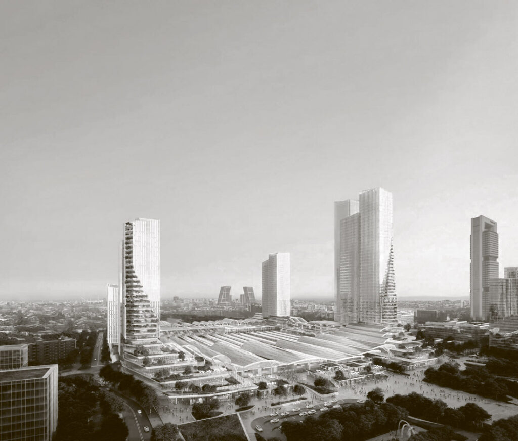 Image of the winning proposal from UNStudio, B720 and Esteyco for the new Chamartín Station.
Owing to its complexity and, especially, to its outcome, the story of the intervention is one of crisis in the model of urban land management. While public consortiums or concessions that allowed public land to be developed by private investors in exchange for a fee would have been the traditional route, Operation Chamartín – initially associated with a competition held in 1993 whose architectural part had been entrusted to Ricardo Bofill – was devised as a very different model: the public land was rezoned to be sold off by a company that took on the bulk of the investment and financially compensated the owner of the land, Adif, the state-owned railway infrastructure manager. As it was largely unprecedented, this model sowed the seeds of discord because it entailed a conflict of interest from the very outset.
The interest of the private developers, with their sights set on the highest possible building density and floor area ratios to make the operation profitable, contrasted with those of the public entities involved – Madrid City Council in this case, concerned because a considerable proportion of the new construction had been earmarked for social housing and were already defined in its town plans. Added to this conflict were changes of government, drawing up of master plans, economic recessions and the particular fate suffered by the private developers, leading to a result that was only too predictable: a process that languished for thirty long years, and was only saved recently, under the mayoralty of Manuela Carmena, by the pragmatic belief that, at this stage of the game, it was better to do anything at all than nothing at all.
It is true that the approved project reduced building density while ensuring the construction of more affordable housing and provided more green spaces, in addition to reflecting contemporary concerns regarding mobility. However, it is no less true that the quantitative concern – the actual core reason for the entire process – had pushed into second place the aspects of urban and formal meaning that should have been given to the operation, decidedly the last or penultimate episode of the history of Madrid’s most important axis. This meaning cannot be assimilated into the simple compromise between the players involved, or to the deal between private and public interests, because it concerns the basic question of whether, in what is destined to be an operation to define for centuries the imprint of three hundred hectares of urban land, the fact that something is to be done – for which an honourable solution had been found to a situation that had been festering for so long – would be enough.
Elaborating on the civic issue, it is highly surprising to compare the disproportion between the time it took to decide on the quantitative and economic terms – the lion’s share of the MNN district project – and the relative speed with which, the closer it seemed that an agreement would be reached, images of the project were released. Giving shape to a city is no easy task, and as we have seen, Paseo de la Castellana as an axis for transit and spatial consolidation has always shown itself to be evasive where planning is concerned. But this should not have removed the opportunity for public debate on the design, the urban form in particular, of the hundreds of hectares of Chamartín railway land, a highly delimited area linked to a single operation. This, without a doubt, would have necessitated more time – a resource it seems is unacceptable in a process that has dragged on for three decades now – and would have involved calls for open design competitions – somewhat superfluous when the developers are private – but it at least would have helped to play down the lack of character of the project to be executed.
On the other hand, the MNN project cannot be more implicitly aware of its limitations as the consideration it had been given right from the very start was less of a statement than it was a sum of corrections. First was the correction of building densities to create complexity and urban life, whose result was an eclectic combination of types and layouts that aimed to mimic the image – but not the real structure – of ‘successful’ cities. Then came the correction of land uses, in order to avoid the ominous zoning of modern town planning, but by making the effort depend more on a quantitative mixture than a convincing urban form. And, finally, came the correction of urban models based on motor vehicles, asphalt and hard surfaces by means of a series of strategies – green spaces, public mobility – that respond to sustainability criteria that have ultimately become so convenient for both politicians and companies. The result is a design with a relevant theme, but whose formal aspects do not seem to go further than bringing a certain longitudinal order – a five-kilometre-long urban island – a certain profile in terms of heights – thirteen towers rising over one hundred metres in height are to be built, the tallest building in Spain among them – and a land use aspect that achieves a large percentage of ‘green’. All of this with an image of contemporary Manhattanism, most likely of great appeal to the public at large because it is a pleasant and sustainable one.
Quantitative pressures hindered the slow, qualitative reading of this difficult part of the city and its relationship with Paseo de la Castellana, Madrid’s spatial axis. Is it appropriate that the new district should depend on a street of dubious scale and nature, Calle de Agustín de Foxá, which will run along the five-hundred-metre façade of the new station and then for several more kilometres before dying in the form of a cul-de-sac? Is a pleasant Manhattanised downtown the character this part of the city needs? Can the urban disconnect be resolved with such weak mechanisms as those of this project? Is it not true that the picturesque layout of closed blocks and high-rises mistakes density for compactness? Is it reasonable that an intervention that removes the railway yard should be turned into a de facto island? Is it worthwhile to cover over the tracks to create a park that, at the moment, has no character other than being a green and decorative strip on the map of Madrid? Should better use not have been made of the linear structure of the enclave to turn it into a corridor for wildlife and services that could connect the future Metropolitan Forest with Paseo de la Castellana to reinforce the spatial meaning of this avenue?
These are questions that the developers of MNN will most likely be able to answer, although, unfortunately, the actual project will not be able to do so. In any case, these questions can also be raised in light of the recent awarding of the new Chamartín Station project, for the most ambitious building-infrastructure to be undertaken by the different public administrations for the next twenty years. Likewise the result of a period marked by administrative and economic complexity, the competition was held with the best intentions by Adif, an entity whose long experience in these types of facilities led to a demanding list of functional, structural, constructive and environmental specifications which ultimately were of little use for the designs, save certain exceptions, could successfully cater to the complex urban situation of the station setting.
A place as marked by the imprint of the railway as this, and urban development so devoid of character as that of the MNN project required that the new Chamartín Station coordinate its nature as a major piece of infrastructure with that of an architecture that could bring true urban order to its surrounds. Taking the exacting technical and sustainable agendas of the competition into account could not guarantee that most of the designs would actually deal with the issue of the design of the city, nor could it guarantee their understanding of the strength that the urban form could have when it came to saving this fragment of Madrid from entropy, given its susceptibility. In this sense, the competition would have been an excellent opportunity to give character to an urban enclave that lacks any and seems fated never to have any. The question then is whether, considering the results that are insufficient in terms of urban planning, a more profound debate would not have been necessary regarding what a station such as Chamartín might mean in such a difficult setting: a debate that could have taken something of the form of a ‘competition contest’.
The imprint of urban planning decisions remains patent in cities for centuries, which begs the question whether this tremendous responsibility should not contribute to other ways of acting and thinking that are more parsimonious, but also more fruitful. What is implicitly the culmination of Paseo la Castellana – the spatial avenue of Madrid – would have needed an architecture of order, an ‘analogous’ architecture that would corroborate and at the same time shake up the pragmatic and spatial nature that has always been a feature of Paseo de la Castellana: backbone, urban adhesive and grand infrastructure of the capital and of capital.