Reframing the World as One City A review of the exhibition “City of 7 Billion. A Constructed World”.
Architecture facing urban theory
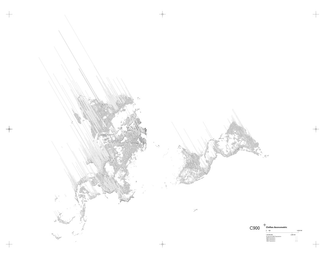
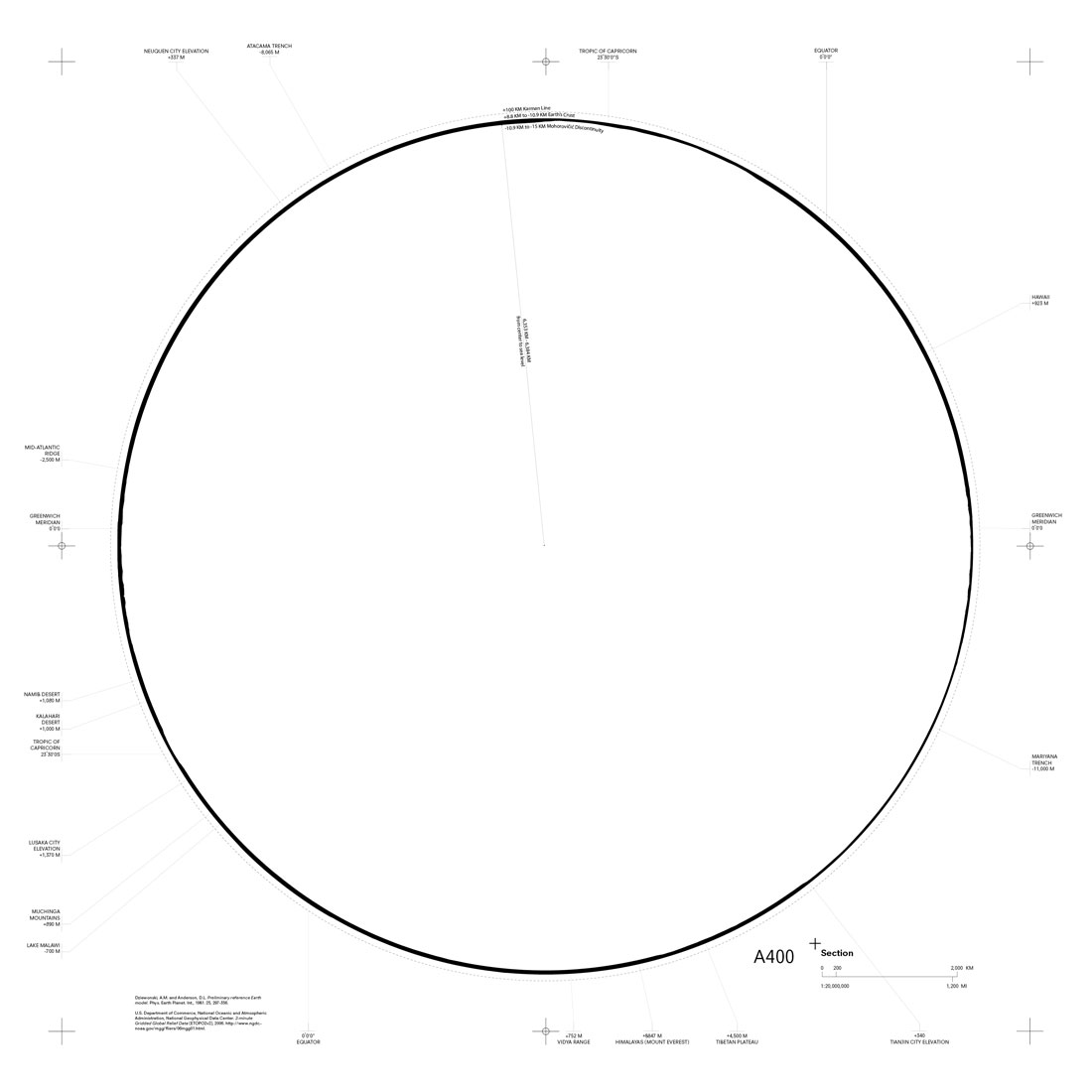
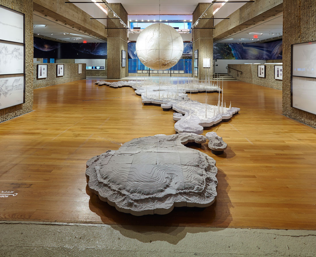
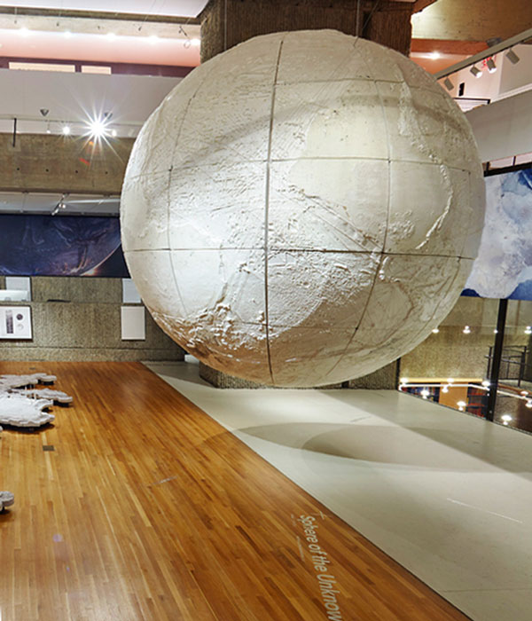
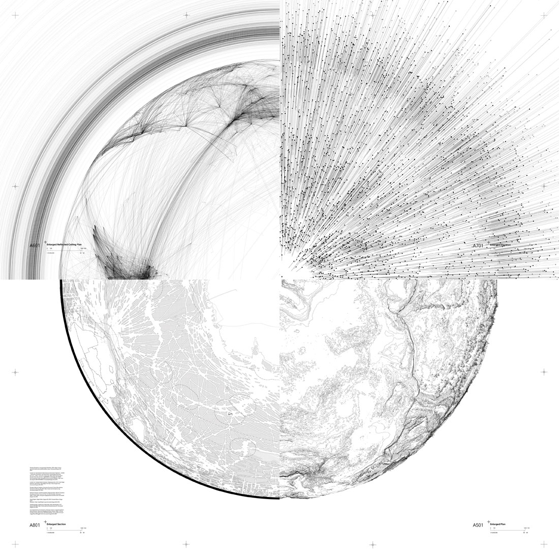
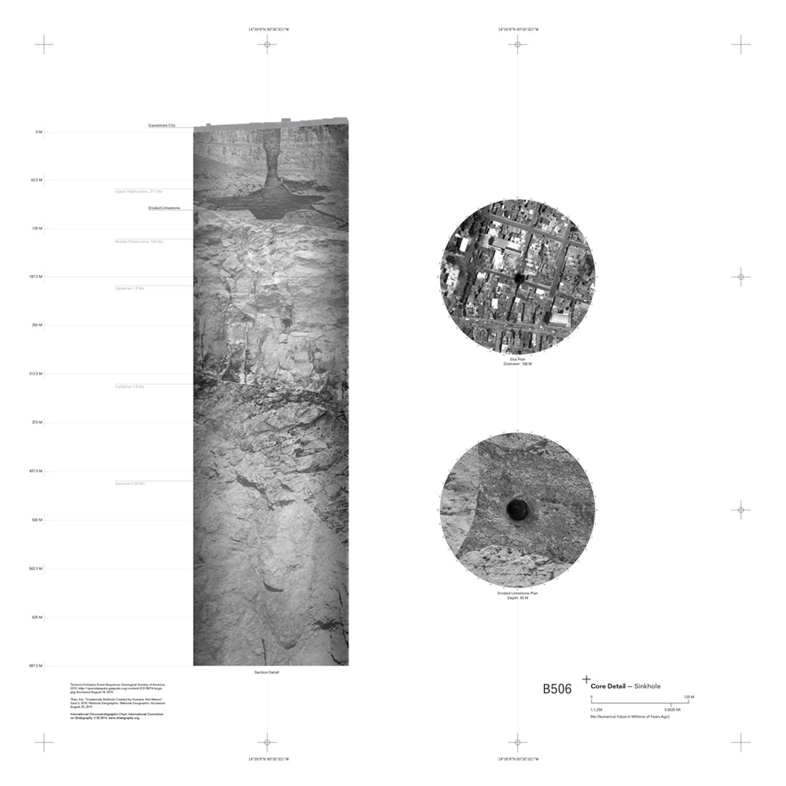
Sectional, planar and axonometric black and white linear renderings of the world and of its agglomerations that displace the representation of the planet from the dominant cartographic conventions into the architectural repertoire (Set of Drawings. fig. 1 and fig.2). Similar visualizations of the world’s forms of connectivity together with its differential densities. Vast models that reunite geographical and man-made information, that erase the individuality of the continents into a single land mass and confound representations of population density with natural geological formations (Figures and Ground. fig. 3) or that present the world as a mesh of connections leaving, yet, significant blank spaces in the net (The Sphere of the Unknown. fig. 4 and fig.5). A continuous, 78-meter-longview of the Earth as seen from the sky, rendered with the hyper-realistic conventions of the 19th century panorama, but changing the central position that the viewer occupied in the latter for an extra-terrestrial and moving point of view that reveals the diverse elements that populate our aerial surrounding (Scenes from the Horizon. fig. 6). A sectional drawing of the wide range of altitudes of urbanization. Cuts showing the kilometrical relationship between cities, geological strata and forms of subterranean occupation (Urban Cores. fig. 7)… All these elements populate the five aforementioned areas of “City of 7 Billion. A Constructed World”, an exhibition recently on show at Yale School of Architecture (September 3 – November 14, 2015) and that culminates a multi-year research project undertaken by Joyce Hsiang and Bimal Mendis, two architects and Yale faculty members. What is the value of these visualizations, both beyond and including their outstanding aesthetic quality?
[Fig. 1] Civilian Axonometric. City of 7 Billion Exhibition. © Joyce Hsiang and Bimal Mendis
[Fig. 2] Earth Crust Section. City of 7 Billion Exhibition. © Joyce Hsiang and Bimal Mendis
[Fig. 3] Figures and Ground model. City of 7 Billion Exhibition. © Joyce Hsiang and Bimal Mendis
[Fig. 4] Sphere of the Unknown model. City of 7 Billion Exhibition. © Joyce Hsiang and Bimal Mendis
[Fig. 5] Composed Enlarged Plan, Enlarged Section, Enlarged Ceiling Plan, Enlarged Elevation. City of 7 Billion Exhibition. © Joyce Hsiang and Bimal Mendis
[Fig. 6] Scenes from the Horizon. City of 7 Billion Exhibition. © Joyce Hsiang and Bimal Mendis
[Fig. 7] Urban Cores. Guatemala Sinkhole. City of 7 Billion Exhibition. © Joyce Hsiang and Bimal Mendis
Discourses on globalization are increasingly impregnated by debates about the urban. Reality and propaganda incessantly emphasize that the planet is increasingly dominated by cities. Yet, the forms in which this may be the case and the extents of this phenomenon are the object of ideological contestation, the origin of disputes that can propel different reorganizations of the spatial disciplines. From one extreme of this debate, it can be posited that the whole world can be conceptualized as a vast, single urban entity; a city-world; encompassing both occupied and unoccupied areas. This is the thesis of “City of 7 Billion”, whose visualizations aim to elucidate how the world can be considered through this unitary approach and what that implies for architectural and urban discourses and practices.
Focusing on the planetary scale, Hsiang and Mendis’s research establishes a dialog with a set of prominent ongoing theories in the social and natural sciences – ranging from Crutzen’s Anthropocene hypothesis to the diverse and conflicting conceptualizations of the so-called urban age, to philosophical, social and political analysis of globalization –which present the planet as completely affected by human action and, significantly, by urbanization. Hsiang and Mendis’s research builds on some of these theoretical approaches, all of them consistently present in the symposium that the curators also organized at Yale, and intends to contribute to their development. Yet, what is important is that, as architects, their work takes a decidedly disciplinary stance to do so. Above all, the exhibition raises the questions of how the world scale can be situated, conceived and made operative for the architectural and urban spatial imagination. In doing so, Hsiang and Mendis’s work joins and expands on a different tradition: that of such architects as, to name just a few, Buckminster Fuller, Saverio Muratori and, in their case especially, Constantinos Doxiadis, whose work focused on how to convert the world into an object of architectural and urban enquiry.
The image of the city: how to address the politics of the notion of “urban”
In “City of 7 Billion” there is an interplay, then, between theoretical debate and architectural speculation. This interplay is elaborated through the sophisticated exercise of cartographic imagination that the five sections of the exhibition deploy. Any spatial proposition cannot exist without an initial conceptualization and visualization of its object of intervention, without an initial act of framing, which– because it inevitably establishes the confines and possibilities of the project – is, often inadvertently, a project in itself. The exhaustive work of cartographic representation in “City of 7 Billion” insists upon the complex circularity between description and proposition and upon the breaches this relation contains. Global visualizations are a project in themselves, which emphasizes the necessity of making explicit statements about the form the world is taking as a whole that supersede the existing lacks we may have in this respect. Despite being conspicuously surrounded by technological devices that allow an immediate access to the world scale and by a multitude of global cartographic visualizations of the diverse effects of urbanization, the disciplines of architecture and urbanism have only barely elaborated critical and, to the extent that it is possible, comprehensive analytical integrations of the diversity of factors mobilized by the intermingling between urbanization and the space of the world. The layering of geographical and geological information, the representation of agglomerations, connections and global hinterlands in “City of 7 Billion” offer a glimpse of the form such an integration can take as well as the operative and the dialogical values it can have.
In “City of 7 Billion” this sort of integration is the gathering of a diversity; albeit a very structured one. The five areas of the exhibition offer various approaches to the form of the city-world. These operate mainly at four specific levels in order to highlight: 1) the variety of elements that constitute the fabric of this city; 2)the overlapping in this fabric of natural and man-made elements; 3) the different and contrasting points of view from which the world-city can be apprehended and 4)the wide range of techniques of representation required for comprehending it and intervening in it. Yet, this plurality does not prevent the formulation of clear statements: it is, on the contrary, the medium through which the representations of “City of 7 Billion” seek to construct a comprehensive and specific image of the city-world.
Since Kevin Lynch and, more particularly, following Fredric Jameson’s reading of Lynch, acts of image construction have been valued according to their cognitive attributes; as an instrument in achieving a unitary perception of a seemingly fragmented reality. [1] This value notwithstanding, the image that “City of 7 Billion” creates is, in my view, more precisely characterized by having the dialogical attributes for which the French geographer Michel Lussault has advocated. [2] For Lussault, the construction of a territorial image– understood as a vision or a project – is both the precondition and the primary place of any territorial politics. In this sense, it is through the images elaborated for “City of 7 Billion” where we can seek out a position vis-à-vis contemporary debates about the relation between urbanization and globalization, and about the role spatial practices may have in managing this relation. My intention now is to outline what I think are the key aspects of Hsiang and Mendis’s intervention in these debates, highlighting three broad and main areas of intervention in them. With this goal, I will maintain the aforementioned diachronic tension, occasionally linking their contribution both with the positions of some of the participants in the symposium they organized and with previous explorations about the scale of the world carried by architects and urbanists. For information purposes, the names of the participants in the symposium are hyperlinked to their respective profiles, offices or labs.
The questioned discreet city, cartographic breaches, and the tension between the Earth and the World.
Succinctly, “City of 7 Billion” intervenes in the following three main areas of debate:
1. How to overcome the discrete city as analytical object
Most narratives of urbanization consider it to be the result of the physical expansion of cities and, therefore, they aim to describe what new urban formations are being constituted or what the conditions of the new constituents of their expansion are. Terms such as exopolis, megalopolis, post-metropolis, urban regions or urban archipelagos belong to the first group; terms as edge cities, exurbs and edgeless cities belong to the second. [3] A common dominant theoretical position underlies them: the privilege of the city as the space of urbanization. [4] This privilege of the city has recently been challenged by Neil Brenner and Christian Schmid’s notion of planetary urbanization. Central to this notion is the understanding of urbanization as a totalizing process, whose effects are both the expansion of the city and the integration of every formerly non-urban realm into the circuits of production and consumption necessitated by the urban.
Put in spatial terminology, for Brenner and Schmid the result of urbanization is not only the production of cities but the production of a planetary urban fabric. As the use of the term “urban fabric” indicates, their position is highly dependent on Henri Lefebvre’s writings. It is in Lefebvre’s The Production of Space where we find a first attempt to construct a “unitary spatial theory” that supersedes the existing segmentation of the spaces by different forms of disciplinary knowledge and by their classification into pre-determined and often segregated scales, such as the city, architecture and territory (01.6), which again become the areas of specialization for particular disciplines and professions, fostering a new iteration of the process of spatial and intellectual division [5]. Lefebvre counters this division of the spaces produced and thought, claiming instead that space is produced in toto and that therefore it must be conceptualized holistically. As a result of understanding the production of space as a unitary phenomenon, the intellectual basis for the distinction between natural and social space is eliminated. Put more succinctly, for Lefebvre the “space-nature” as a distinct entity disappears, since even the very distinction itself is culturally mediated (01.14). When, in The Urban Revolution, the author attempts to create a chronology of the development of the urban and conceives contemporary geography as approaching the moment of a planetary total urbanization, it becomes clear that in this phase the space-nature has disappeared because of its complete integration within the networks of the urban, and that the latter is both the spatial form and the spatial trigger of the processes of capitalist production [6]. Brenner’s attempt with Harvard’s Urban Theory Lab to analyze the planetary dimension of the urban, not through the abolition of the discrete city by its integration into a continuous planetary city but through the incorporation of formerly non-urban realms into the urban circuits of production, is a consistent development of this position.
Hsiang and Mendis’s work can be aligned with Lefebvre’s and with Brenner and Schmid’s position. The analytic privilege of the discrete city is put aside to favor instead the consideration of the global circuits of material production, communication, etc. in which cities are inscribed. The planar and sectional representations of connections and areas of production and resource extraction insist on this point. However, there is another aspect of Lefebvre’s writings that “City of 7 Billion” elaborates more thoroughly. For Lefebvre, the functional analysis of this holistic process of space creation neither impedes the necessity of a structural and formal analysis of the space produced nor the consequent understanding of the scales, forms, textures, etc. that the urban is acquiring (02.14). Hsiang and Mendis’s work is particularly strong with regard to the elaboration of this aspect, offering at least two key points to formally approach it. First, agglomerations are represented as a continuous system in three-dimensional interaction with geographic space, in contrast both to previous speculations about a global continuous urban system – such as Doxiadis’s merely planar representation of Ecumenopolis or the mere superposition of Richard Florida’s Spiky World over the geographical space – and to the inverse segmentations of urban areas when analyzed in contact with geographical space – in the manner of Jean Gottman’s Megalopolis. Second, networks are not considered as an immaterial space of flows but as three dimensional physical traces and infrastructural equipments. In summa, the physical form and structure of the urban fabric is at least presented through the overlap of three dimensional constructed flows, sectional geographical and geological conditions and the volumes of agglomeration, presenting then this overlap as the basis for our contemporary reflections about the forms and possibilities of the city.
There is a corollary to this approach to the planetary city. Although in the analysis and visualizations conducing to the exhibition the authors explored some diachronic dimensions of the “City of 7 Billion”– even as projections toward the future, the final project privileges a synchronic, static view of the urban fabric. Since its conceptualization, urbanism has always had a strongly temporal, process-oriented component; its conventional definition vis-à-vis architecture has historically highlighted the divergent temporalities the two fields manage. From a theoretical standpoint this temporal dimension has been recently taken to the extreme by Brenner and Schmid: in the conditions of planetary urbanization, the urban is no longer a form but a process. This emphasis on process rather than form has also been repeatedly taken into consideration by the spatial disciplines, occasionally associated with the incorporation of the values of flexibility and change the contemporary world allegedly requires. Pierre Belanger, among others, has, for instance, insisted on the necessity of intervening and managing a space of material and immaterial flows. Urban metabolism and other ecological approaches have equally focused on the necessity of managing processes. “City of 7 Billion” seems to privilege the other side of the form-process equation, stressing the relevance that formal and material analysis and propositions may still have.
2. What is to Be Done with “objective” global geo-spatial information and with critical cartography?
In order to produce the visualizations of “City of 7 Billion”, a significant amount of geo-spatial data was employed. However, this data was carefully re-elaborated and questioned. Significantly, the Drawing Set part of the exhibition opens with a blank map of the world, followed by a version of Lewis Carroll’s Chart of the Ocean in The Hunting of the Snark. One of the centerpieces of the exhibition, the huge globe Sphere of the Unknown, representing the world at a scale of 1:3,000,000 and the material and immaterial infrastructures that connect it and survey it, shows both the blank spaces between these nets and the intricacy that characterizes them, highlighting that the very complexity of this intermingling of connections is what produces unknown, and therefore uncontrollable, realms.
Yet, behind this questioning of the data employed and of the processes and elements that attempt to facilitate the comprehension of the world, there does not lie any sort of epistemological incommensurability. What is at stake is the proposition of a different cognitive attitude toward data, in contrast both to geospatial claims for objectivity and to the alternative tradition of critical cartography.
The architect and geographer William Rankin has posited that spatial constructions based on GPS technologies presuppose detached attitude toward the world – a sort of omniscient view inherently alienated from contextual realities – often combined with an implicit scientific objectivism vis-à-vis the conditions they describe. Alternative to this position, especially to the latter factor, there is a tradition of radical and critical cartography – present in Rankin’s own work or in the activities of Brenner’s Urban Theory Lab, John Palmesino’s Territorial Agency or in Pierre Belanger’s work –which employs geospatial information in order to render visible the spaces, connections and dynamics that are commonly left to one side by geospatial representations. Geospatial and other sources of information become, therefore, an instrument to make knowledgeable hidden aspects of the global condition. In parallel, the reflection they spark about the very mechanisms that geographical representation employs, and the attempt to challenge these conventions, is a tool to render visible the ideologies that support dominant spatial conceptions and the ways in which they are already embedded in representational forms. As critical instruments, their goal is to question these ideological constructions and, eventually, from these critical positions, open up new spaces for spatial or political action.
The visualizations of “City of 7 Billion” are indebted to this tradition of critical cartography. Its consistent use of Fuller’s Dymaxion projection, the negation of the separation between continents –substituting the representation of the coastal limit by that of the territorial waters-, or the introduction of conventionally non-urban dimensions into its representations of the urban adopt or continue previous critical explorations. However, as mentioned previously, “City of 7 Billion” does not follow the conceptual framework of critical cartography. Its insistence on the non-knowledgeable has another face and is oriented toward a different horizon. When geospatial data is employed in “City of 7 Billion”, its supposed objective condition is always rendered as manifestly insufficient: as a necessarily unaccomplished project of comprehension of reality. “City of 7 Billion” shows that a big gap exists between the world that is represented and its supposedly objective representations, not in order to denounce their inaccuracy but rather to highlight the positive value of this gap for spatial speculation. (fig. 4)
Aesthetic propositions and architectural and urban projects operate through that representational breach. Any GIS map of urban extents is an extreme abstraction of the actual urban conditions it allegedly represents, a fact rendered evident not only by the debates about the relative accuracy of alternative representations of urban extents but also by the diversity of urban forms that any of them contains [7]. Yet, this abstraction can be appropriated to project which conditions and forms the urban could adopt. In this projection, data is overcome by spatial forms and aesthetic positions. It loses its objectivity, becoming nothing, unavoidably, but the origin of an interpretation that necessarily exceeds its original source. An interpretation that– in its now obvious difference regarding reality – reveals the pre-existing difference between data and actual geographical or urban conditions.
Methodologically, this displacement into an aesthetic and projective realm is the opposite of sublimating the data. It also contravenes the merely critical use of geo-spatial information. Conventionally architectural in this respect, it points to a project of reality or to the construction of an architectural or urban imaginary. In this proposition, the systematic use of white and black renderings, which decompose every volume into its outlines, extremes the conceptual overlap between urban and non-urban realms. It equates the means of representation of the urban with the lines employed to represent the world’s meridians and parallels, its topography, the networks of communication that cross it, or even with the messages contained in them. The proposed world is a matter of lines. Although entirely occupied, it can be, still, substantially hollow and essentially light – in the manner in which lightness is considered in Italy Calvino’s Memos or in Michel Serres and Marcel Henaff’s Global City, to name some references close to the curators’ discourse [8]. As in the work of the latter authors, the world is also a place of transpositions and movements: of territorial detachment. In that sense, the elevation of the epistemological abstraction of geo-spatial information to an aesthetic code legitimizes architectural sameness and, through it, the cross-geographic encounter of equivalent urban forms. Instead of a world of fragments and differences, we are confronted with a world of repetition and homogeneity. One where the global disguise of equivalent architectural and urban operations in particularized iconic or contextual dresses is substituted by the recognition of sameness as a fundamental and desirable constituent of its universal ethos.
3. What are the possible relations between Earth system and World system?
John Palmesino explicitly made this distinction between Earth system and World system, where Earth and World are respective emblems of the natural and the man-made, in order to point to a fundamental problem when reconsidering how to conceive urbanization. The interaction that this distinction implies could, in fact, be considered as the common thread linking the attitudes that most of the diverse forms of disciplinary knowledge congregated at the symposium – from Earth sciences to geology, from urban metabolism to social sciences – deploy toward the global extension of urbanization.
This interaction is generally– and correctly – characterized by the perverse forms of exploitation of the planet derived from its total integration in the circuits of economic production and by the direct deleterious effects that urbanization, and the forms of capitalist production and consumption that propel it, have on the planet. Both considerations support the wide concern about the huge alteration of natural ecosystems mankind is producing and have subsequently informed the construction of ecological and politico-ecological discourses aimed at the understanding and critique of this situation and at the elaboration of instruments to counteract it.
This lens is present in “City of 7 Billion”, especially in as much as it adopts an analytical framework close to Brenner and Schmid’s differentiation between concentrated and extended urbanization in order to show that the city-world is formed both by agglomerations (concentrated urbanization) and by the diverse landscapes and territories of extraction, production, etc. that it mobilizes (extended urbanization). However, together with this more consolidated concern for the ecological impact of urbanization, Hsiang and Mendis’s contribution to the urban debate is particularly interesting in their elaboration (and recuperation) of another dimension of the relations between Earth system and World system – one which, in any case, brings their work back to the ethics and intentions of the ecological discourse.
The first analysis of the expansion of urban systems beyond the metropolitan scale highlighted the strong relationship between these built systems and geographic conditions. Le Corbusier’s Natural Occupation of the Territory in the Three Human Establishments considered that the linear cities uniting radio-concentric metropolises would follow specific advantageous geographic conditions, especially linked to connections between land, rivers and sea [9]. Doxiadis’s Ecumenopolis followed a similar logic. What he termed as factors of special attraction guided urbanization along geographical axes; coastal areas and flat land zones concentrated the highest densities [10]. Muratori’s Atalante and Civiltà e Territorio took an equivalent position to the extreme, claiming for the necessity of constructing the Ecumene according to inherent territorial logics which should allow us to read the territory as an integral part of civilization [11]. These analytical and projective links between post-metropolitan formations and geography have been, however, left aside in more recent analysis of the impact of globalization on the formation of a new territorial, urban order. The dynamics of deterritorialization that are integral to capitalist logics of interchange do motivate an alienation of urban formations from the actual locations where they are settled. Paradigmatically, in the urban models derived from the Global City theories, from John Friedmann to Saskia Saasen, cities float in an undetermined blank space – uniquely existing in their networks of connections. More precisely, and going beyond Global City theory, the contemporary logics of liberal market connectivity construct relations that are, in fact, trans-scalar, multi-scalar and discontinuous. Places may be connected intensely and primarily to a distant location, only to come back secondarily – if at all – to their contextual, geographic realm.
The ubiquitous networks of “City of 7 Billion” acknowledge the relevance of the latter factors. Yet, the exhibition shows that deterritorialization happens within a complex, and we could say multidimensional, physical territoriality, whose fundamental relevance has to be highlighted and studied. In this situation, the physical impact of urbanization is seen in terms that follow and expand the interactions between geography and urbanism envisaged by Le Corbusier, Muratori, Doxiadis and the like. Hsiang and Mendis follow the works of these authors, presenting the expansion of urbanization as a geographical phenomenon. In contrast to them, “City of 7 Billion” expands their mostly planar approach, seeing this phenomenon as also sectional and temporal: two dimensions that are presented as potential catalysts of urban and architectural possibilities.
The interplay between Earth system and World system is therefore mostly considered through the possibilities opened up by this expanded territorial lens. As indicated, the planetary agglomeration is presented as a sort of specific geography that combines natural topography and volumetric built form, opening up an exploration of the precise formal relations that can be constructed relating these two aspects. The consequences of this sectional relation are further explored at different scales. Globally, one of the first drawings of the exhibition is a section of the whole planet showing only the relation between its exterior topography, perfectly circular at the drawing’s scale, and the notable varying depth of the Earth crust. This depth is then depicted in detail in the cuts of the Urban Cores as a built and inhabited space, explicitly presenting the production of this space as an object of architectural and urban production. Materiality and temporality –and, more directly, the deep temporality of geology as addressed by Mark Williams–are directly seen as a key question in this regard, since the progressive sedimentation of multiple built strata on natural ground is what finally made both systems indistinguishable: what was artificial became natural. Reversely, multiple systems of connection, extraction and infrastructures penetrate deep into the crust, integrating a former nature within the domain of urban space.
In 1967 Muratori claimed that, in geographical terms, mankind had dominated entirely, but only, on the surface of the planet. Now, “City of 7 Billion” shows an intense sectional and altitudinal occupation. No doubt, others have explored a similar path – Belanger and Brenner, for instance, among the contributors. The specificity of this project resides, again, in its insistence on not separating this dimension of the global city from the set of aspects conventionally and historically included in the practices of architecture and urbanism: materiality, temporality, forms of relation, and forms of visual experience. After representing the altitudes of urbanization in section, the panorama of Scenes from the Horizon highlights the visual repercussions of the constructed aerial stratum. Contemporary to Muratori, in 1967, Alison and Peter Smithson, who were already concerned with the ubiquity of the urban, reframed the relations between architecture, urbanism and territory in Urban Structuring [12]. They gave the name Ecological Table to the sectional orchestration of land uses, architectural typologies, forms of human association and forms of connectivity according to different overlapped horizontal strata. “City of 7 Billion” expands this ecological approach to urban form, from the depth of the Earth’s crust to the atmosphere.
4. Politics
So, what about politics? Although present in diverse forms in the discourses of the participants, politics was not specifically addressed in the symposium [13]. Moreover, even if I framed the previous debates as a derivative of the political image that “City of 7 Billion” as a whole may construct, they are in fact debates about how we frame disciplinary approaches to a particular scale of urbanization.
Yet, it is of course through our disciplinary positions that politics is present in the fields of architecture and urbanism. If the polis has been the historical emblem of the political space, “City of 7 Billion”‘s interest in the construction of the planetary scale of urbanization as a city can be seen, after all, as an attempt to investigate what aspects have to be taken into account by the physics of a political space attuned to the scale of globalization. Contemporary practices of architecture and urbanism are often involved in enquiring how a city can be built out of the seamless metropolitan and post-metropolitan scales. Meta-geographic analyses are relevant because they operate at this point. Already in 1981, Manuel de Solà-Morales pointed to this fact, stressing that in order to construct the Catalan territory as a political entity after the dictatorship in Spain, it was first necessary to understand the forms and constituents of the totality of its territory – both urban and non-urban [14]. Far from being a form of legitimizing existing spatial structures, his enquiry was an instrument for reconsidering the existing situation, finding common problems and potentials and seeking the corresponding diversity of scales and means to act on them. “City of 7 Billion” projects a similar enquiry to the extents of the whole world. In doing so, it reiterates the necessity of elaborating meta-geographical analyses to inform other scales of intervention, bringing back the results of that universal position to a diverse range of scales. As a result, and through its emphasis on architectural operations, “City of 7 Billion” stresses the possibility of progressively building this space and the role of architecture in that process. The construction of the city-world is for sure a complex, variegated, multi-disciplinary enterprise, which does not leave architecture unaffected. Coming after a century-long tradition of architectural speculation about the planetary scale, often envisioned through radical reorganizations of the planet, “City of 7 Billion” faces a situation where that planetary scale is de facto an existing reality. Impossible to construct ex novo, this reality has to be addressed rethinking, with it in mind, the aesthetics, forms of vision, materials and dimensions that architecture manages and bringing to the forefront the relations created through those operations. Reflecting upon the possibilities of a geo-philosophy and thinking well beyond existing forms of democracy, Gilles Deleuze stated that: “If there is no universal democratic State, despite German philosophy’s dream of foundation, it is because the market is the only thing that is universal in capitalism [15].” Politically, “City of 7 Billion” asks what our spatial universals could be and urges us to follow that investigation.
Addendum
The exhibition “City of 7 Billion” also presents a sample of the work of the contributors to the symposium and therefore already shows a variety of approaches toward the planetary scale and the diverse disciplines involved in the process. This includes contributions from the social sciences (Neil Brenner and Urban Theory Lab), Earth Sciences (Mark Williams, Kathryn Sullivan), Cartography (William Rankin), Philosophy (Peter Sloterdijk), Anthropology (Tim Ingold, Aihwa Ong), Art (Adam Lowe),and Architecture and Urbanism (Lucia Allais, Pierre Belanger, Adrian Lahoud, Mark Wigley, Liam Young, Nicholas de Monchaux, Clara Irazabal, John Palmesino, and Hashim Sarkis with Roi Salgueiro and Gabriel Kozlowsky).


