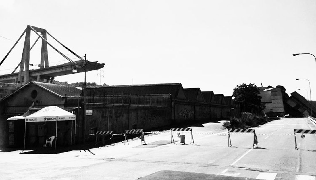
I- The Morandi Bridge, The Fragility Of An Unappreciated Heritage
Many readers will no doubt have crossed on more than one occasion – and not without a certain vertigo – the Morandi bridge, no longer standing, from France en route to the center or south of Italy. It was an almost obligatory stretch of the A10 motorway that many Genoese used several times a week because of its crucial role in urban mobility.
The Morandi bridge was a beautiful structure designed by the engineer who gave it its name: it was an elegant, slender, very high bridge, on par with other top global engineering works such as those of Maillart, Freyssinet or Torroja, and it had become an icon and an authentic part of the city’s modern heritage, despite not always being well accepted by the city’s inhabitants.
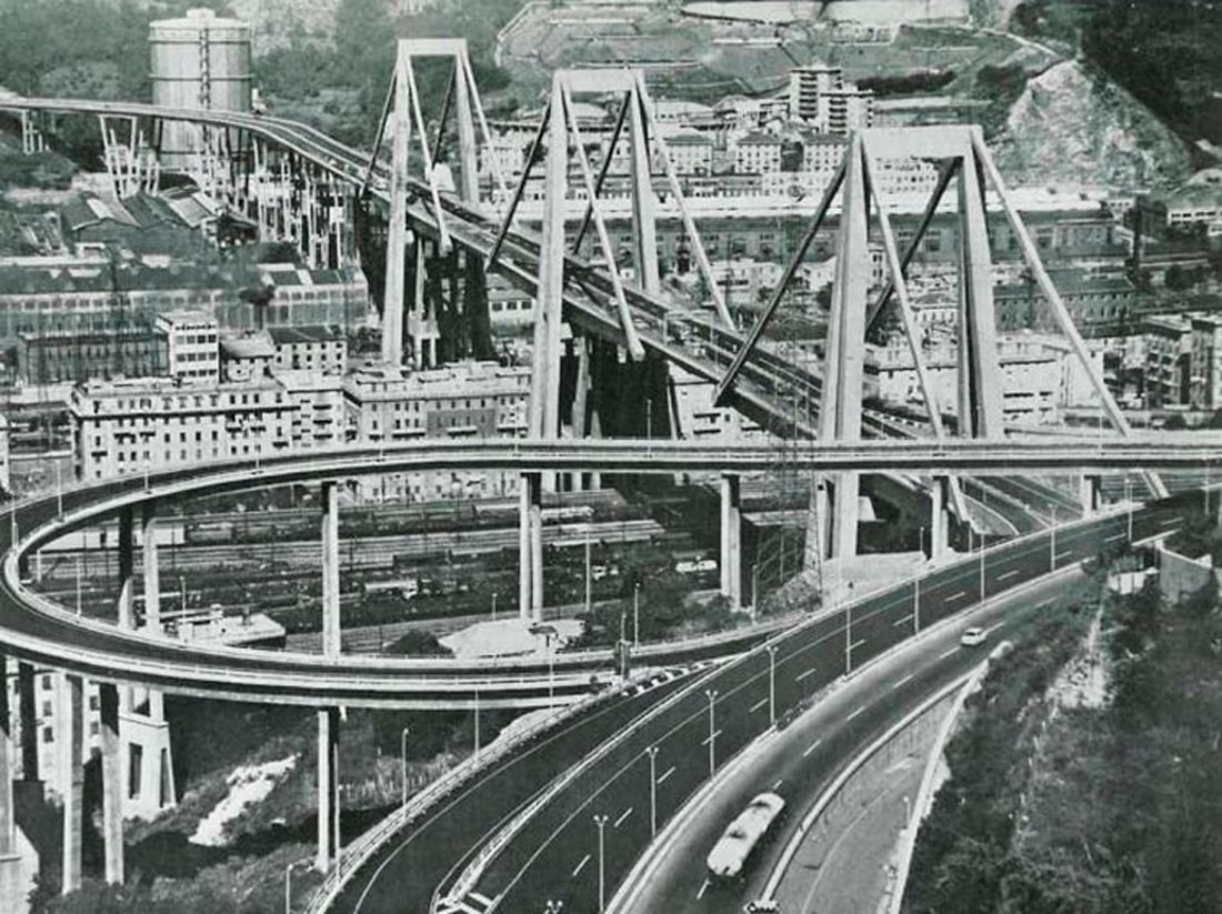
Built between 1963 and 1967 by the Italian company Condotte d’Acqua, the bridge had a length of 1.18 kilometers, a height of 45 meters and three large A-shaped concrete supports that reached 90 meters. The length of the main span was 210 meters.
To cover the large span of the bridge, the engineer Morandi designed an optimized structure in reinforced and prestressed concrete. The bridge cables were also coated in prestressed concrete, with the main purpose of protecting them from the elements (an innovative constructive solution that the engineer had successfully tested in other international projects but that was later revealed to be quite complex).
The most characteristic and original part of the viaduct consisted of the three central supports, in the form of a “sawhorse”. Each of these supports had two different structures: first, one in the form of a quadruple H that supported the base; and a second structure shaped like a double A, 90 meters in height, that supported the four cable braces and the road surfaces, in sections of 150 meters in length.
This structural configuration made it possible to cover spans of 200 meters for each tripod and to support another “connector” section between each of the pieces. The remaining portion of the viaduct, which stretched westward over the bed of the Polcevera River, was supported by six reinforced concrete V-shaped trestles. The goal of all these design solutions was to minimize the portion of land occupied by the supports, since in the 1960s the area had been densely occupied by urban development, including housing, industrial buildings and other infrastructures.
After almost 60 years of service, the bridge suffered from pathologies and maintenance problems, due in large part to the problems with the concrete and the environmental conditions of a seaside port city, with heavy rains, floods and landslides (Ricardo Morandi himself pointed out in the late 1970s that the sea breeze and fumes, as well as the corrosive properties of the nearby steel mills were causing serious damage to the metallic elements and that concrete surfaces and warned of the need for proper maintenance of the infrastructure).
Genoa is a beautiful and very interesting port city (historical, architectural and strongly infrastructural at the same time) which has once again entered international tourist circuits. It is a city accustomed to negotiating with a complex geography in what can sometimes be unlikely situations, making the most of its resilience. Many players, some of them with a vested interest, had argued for the need to replace the old Morandi bridge with a new more contemporary and less expensive structure.
Others, with whom I personally agreed, defended its preservation, promoting instead an urgent thorough renovation and a pinpointed structural intervention. Beyond the economic reasons, they cited the cultural value of an exceptional project and the bridge’s heritage significance – associated with the modern epic – which has not always been given much importance in the context of a more historicist devotion to the past.
But this required taking urgent measures, which were not always espoused with enough vigor due to the economy, the existing contracts, and the timeframes characteristic of public management. An added difficulty was the ambiguous character of the intervention (functional and/or patrimonial?) which was not always on the mark in terms of its true complexity.
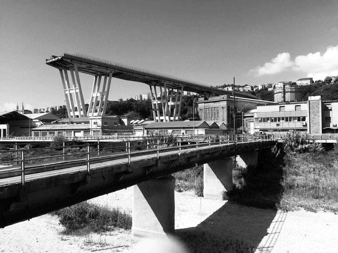
Everyone was aware of the urgency of making decisions, that could no longer be postponed, although it would have been difficult to foresee a disaster with such far-reaching consequences. It is still difficult to pinpoint the exact causes of the collapse, which tend to be (as in most cases of a collapse) multiple and simultaneous.
The causes that have generated the most consensus refer the collapse of the cables on the south end of the bridge, probably due to the corrosion of the steel on the interior. The fall of the connector and the subsequent imbalance of the system led to the collapse of the entire central section. It is debatable whether some responsibility should fall on Morandi’s calculations and his designs, which deserve a certain initial respect.
Beyond the structural calculation itself and the conception of the project, it is necessary to analyze in detail the recent maintenance interventions and expansions, the adverse weather conditions, the reinforcements of the foundations, the impact of the corrosion and erosion of materials, which were, perhaps, not always properly addressed, etc.
Engineering has always been very important in Genoa and its Polytechnic School is one of the most prestigious in Italy. An early analysis and an accurate diagnosis have already been issued, delving further than the initial impressions.
Furthermore the design and construction – racing against the clock – of another viaduct (by Renzo Piano) is under way, setting aside, perhaps a little hastily, other interesting layout options that would preserve the remains of the old bridge, the large “sawhorses” and sections of road that are still standing in the Campasso area, as possible recyclable structures for civic uses and associated public spaces.
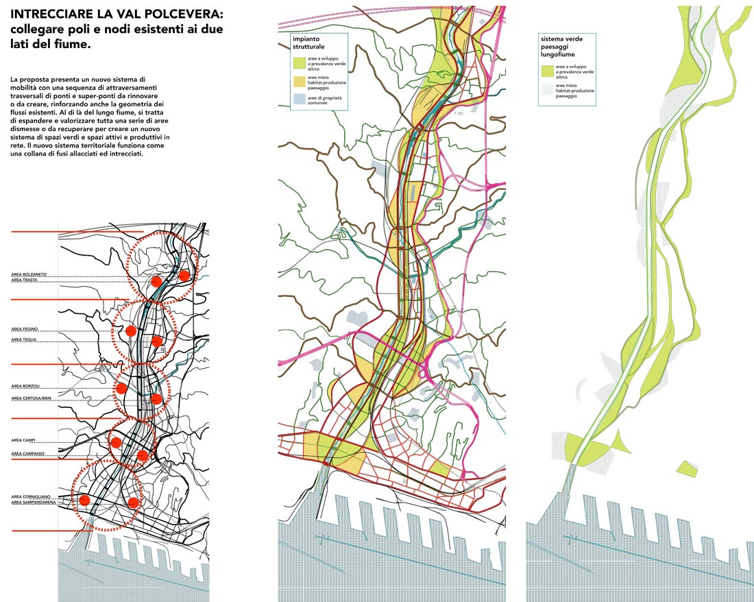
II– Reinforming The Polcevera Valley
That being said, the challenge now is not the construction of the new bridge (and its possible combination with the consolidation of the remains of the old one) but the treatment of the entire Polcevera Valley – a river valley with a wide variety of urban, landscape, industrial, and heritage structures, which existed for years with its “back to the city”. That valley, today, can be (re)signified – treated with ambition and urban quality – as a new fundamental focal point in the city.
This urgent question was addressed by the Integrated Architecture, Urban Planning, and Landscape Laboratories led by Carmen Andriani and Manuel Gausa together with Adriana Ghersi, as well as the Winter Workshop and the exhibition presented at the same time (January 4–11, 2019).

In this case, the theme did not address constructing a specific bridge but rather “building bridges” – between territories, cities, landscapes and citizens, which are infra-connected due to today’s fragmented reality.
The objective of both laboratories encompasses the analysis, reading and interpretation of the complex reality of Val Polcevera and its future projection, in a holistic vision with a comprehensive definition that extends beyond the just viaduct itself: the creation and development of connections and interconnections, intersections and crossings, actions and interactions in a territory that is characterized by an accumulation of unresolved tensions. Here, the coexistence of infrastructure, housing and geography has always taken the form of an addition of parallel fronts, which are sometimes mutually indifferent and sometimes (often) dialectically conflicting.
The territory of the Val Polcevera sees a continuous flow of goods and people: it is a landscape of passage; a landscape formed by the sum of all these transits, which is often experienced by those who cross it only as a place of rapid travel and passage.
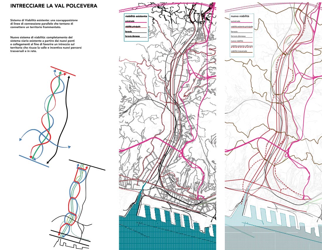 In that sense, the idea of a “Passage to the West”(Andriani) translates that territorial gaze onto a broader scope, while the term “Crossland” (Gausa) translates the desire to “weave” the Val Polcevera by fostering the emergence of a latent, infrastructural and landscape-related geometry, tied to its condition of fluvial (multi)flow:
– weaving together the Val Polcevera
– strengthening and highlighting a latent (infra)structural geomorphology.
The project and the proposals presented might be synthesized as:
– shifting from a cumulative structure of longitudinal road lines along the river to an (inter)woven mesh geometry
– shifting from a series of disjointed and frayed peri-urban fragments on either side of the river (large factories, warehouses, sprawling urban fabrics, vacant spaces, low-density rings) to a system of well-profiled and inter-related spaces (zones or urban clusters)
– rediscovering the fluctuating geometry of a series of local, urban and landscape-related identities, intertwined into a new networked geourbanity.
– providing a sequence of six transversal large bridges (reinforced or designed ex-novo) and 12 footbridges or walkways for pedestrian or slow connections, associated with urban routes and landscape paths connecting with the nature of the nearby hills.
Based on these general strategic decisions, the challenge also focuses on:
– consolidating, and extending the future promenade along the river (to be designed and developed) through a strategic sequences of surfaces “in zones” conceived as new operative landscapes (active green) to combine green spaces, architecture and functional programs for social and cultural exchange
– defining a whole series of sectors (indicated using different segments) connected to the main bridges, and intended to be envisioned in terms of mixed programming (housing, production, open spaces facing the river, etc.)
– recovering and/or recycling abandoned structures, with new production and/or living activities.
– expanding the leisure sector, trade and innovative production in mixed structures where the recovery of old industrial facilities can be integrated and combined with the respect for the identity and domestic circumstances of existing neighborhoods, the resilient landscape approach to the environment and an important commitment to qualitative planning, both methodologically and expressively and formally.
All this is intended to reinform Val Polcevera as a new point of reference for Genoa, combining innovative development with social and urban self-esteem.