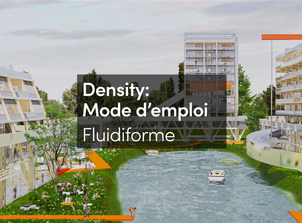
The understanding of Architecture, Landscape and Urbanism as a form of inquiry rather than a professional practice suggests fundamental –operative- changes in the disciplinary procedures, to go beyond analysis-solution, problem solving or remedial approaches, opening them up to the potentials that the subjects immanent to these disciplines provide. This re-positioning of the disciplines along a ‘research by design’ agenda demands an effort to clarify some of the inherent contradictions suggested by David Leatherbarrow (2012), in the joining of research (understood as mainly observational) and design (mainly generative). The Landscape Urbanism MA at the Architectural Association and its associated practice Groundlab have engaged with the emergence of these contemporary positions through its subject-matter: Landscape and Territory, their influence in related design practices and impact in contemporary environments.
‘Land Formations/Tectonic Grounds’ are here presented as subjects of a research by design inquiry through which we intend to understand their historical approaches and re-define mentalities towards landscape (Cosgrove) and territory (Elden) concepts, relevant to concrete realities. In order to do this, we acknowledge and build, our position, upon the ongoing re-appropriation and re-definition of landscape and territory in contemporary research by design practices (Sordi) and therefore our proposal aims to contribute to this development by putting forward these two, intrinsically linked and inseparable, research concepts. They encompass the study of geomorphological formations of landforms (Tectonic Grounds) along with cultural, political and economic forces that drive and choreograph social formations present on these grounds (Land Formations).
We understand this as a crucial and fundamental project of research by design through which alternative landscape organizations (produced by the careful and intentional intersection of land formations with tectonic grounds in specific territories) can emerge as the foundations to any new landscaped territorial environment and by extension to any architectural intervention. These landscaped territorial organizations in turn are a pre-condition, a foundation (a literal ground to architecture fundamentals), upon which any architect and/or designer intervenes through the architectural elements (the door, the ceiling, the window, etc.) that have been defining by the discipline, anytime, anywhere. These landscaped territories delineate the approach, the character and the identity of such elements (geographically and historically) as cultural productions, the ones absorbing modernity.
Tectonic Grounds
On the one hand landforms such as meandering rivers, coastal erosion/sedimentation, sand dunes, riparian landscapes, deltaic morphologies, have been repetitively constrained, controlled or hidden away when confronted with modern human developments and interests in the construction of manufactured territories. By levelling the ground, tunnelling the mounts, channeling streams, damming rivers or freezing dunes a constant reassertion of efficiency, free flow and frictionless environment has been designed to facilitate its administration, governance and ultimately profitability.
Eventually by prioritizing efficiency and profitability, human inhabitation has been compromising the resilience of these tectonic grounds. The undermining of this crucial and immanent capacity in their performance, has among other outcomes the expansion, exponentially, of potential and actual risk areas in and around them. Extreme weather conditions, such as tsunamis, hurricanes, storms, thus, accentuate flooding, sea surges, tidal events, landslides or sand storms with sudden devastating effects. Weaken geomorphologies -by technocratic implementation of efficient goals or abated by the inevitability of humans to inhabit them- are struggling to cope with the inescapability of climate change and the emergency derived by the proliferation of defenceless human settlements. [Fig. 01]

[Fig. 01] Valeria Garcia and Yunya Tang (2014) European Flooding Scenarios showing the modified European coastlines by rising water levels. Cartography. Architectural Association Landscape Urbanism MA 2013-14.
Land Formations
On the other hand, parallel to any tectonic ground are, land formations: social, economic, cultural, and political processes and dynamics forming associations, networks and systems cutting across, at different scales, entire regions. In many cases, these land formations get actualized in specific patterns or spatial organizations, (agricultural plots, urban armatures, landownership patterns, infrastructural networks, logistic facilities, etc.), which in turn shape and configure territories to facilitate its management, distribution and/or administration. [Fig. 02]

[Fig. 02] Liam Mouritz, Chan Ting Fu and Xiabin Hu, (2015) Index drawing depicting the social formations (fish products and goods) from and to Lake Manzala, East of Nile River. Architectural Association Landscape Urbanism MA 2014-15.
Tectonic Intersections
Through the design of alternative forms of interaction in the form of potential scenarios, we build the grounds for a decision-making process that negotiates between these tectonic grounds and land formations and the various agencies at stake. Naturally, these two concepts provide contradictory and sometimes opposing forms of organization. This way of operating responds to the complexity of the intersection of these conditions, especially regarding issues of predictability and simulation as well as territorial contingencies and differential development in time phasing. These scenarios constitute in turn, a form of reverse-engineering research. As architects, we often operate back and forwards from within the specificity of site-conditions to the production of knowledge via the extraction of more generic rules and guidelines. [Fig. 03a & 3b]

[Fig. 03a] Niki Kakali and Anastasia Kotenko (2014) Sand Scripted Digital Simulation Models to abstract generic principle of Dunes formations. Architectural Association Landscape Urbanism MA 2013-14.

[Fig. 03b] Liam Mouritz, Chan Ting Fu and Xiabin Hu, (2015), Phasing strategy of the designed sedimentation processes in the Damietta Spit through the simulation in a Coastal Evolution Model. Architectural Association Landscape Urbanism MA 2014-15.
Whilst the study of this interaction is not new, different agendas have been stressing different aspects of each while failing to create a comprehensive approach towards their interaction. Avant-garde approaches (such as the so called Bio-mimicry, Biological, generative, parametric and evolutionary design) emphasize quantitative approaches to the qualitative conflicts (Specer). On the other hand, social-political awareness links design practices to specific contexts and realities but disregards the material capacity of landscape and territorial techniques as mechanisms to test their own visions of potential futures.

[Fig. 04a] Liam Mouritz, Chan Ting Fu and Xiabin Hu, (2015), The intersection/negotiation between designed sedimentation processes in the Damietta Spit and existing Fish Industry and rural villages in the coastal area of lake Manzala. Architectural Association Landscape Urbanism MA 2014-15.
The medium through which we face the challenges of these necessary intersections is, on the one hand, the constant production and iterations of digital modeling and simulation of tectonic grounds and land formations, and on the other, the experimentation with cartographic means of representation to critically address their impact into specific territories. Through the use of digital modelling and cartographic means, Landscape Urbanism at the AA envisions potential scenarios to strategically intersect infrastructural networks that use riparian landscapes as its engines, industrial forestry patches that interact seasonally and productively with neighboring shifting dunes or meanders that provide novel urban armatures and frameworks to endanger cities by natural disasters [Fig. 04a, 4b & 05]. These operations are not seen as direct alternatives to existing territorial formations, since they will not match common ambitions, traditional targets or efficient bench marking schemes of corporate territorial management. Neither have the capacity to comply every aspiration in a given territory, but rather they aim to provide the means to design unconventional scenarios that efficient and streamlined principles per se have restrained by the implementation of technocratic and efficient goals.

[Fig. 04b] Niki Kakali and Anastasia Kotenko (2014, The intersection/negotiation between forestry plots and sand dunes structure in the Curonian Spit Territory, Russia-Lithuania. Architectural Association Landscape Urbanism MA 2013-14.
Finally this proposal taps into the existing potential of cartography as a projective tool –embedded in their nature, as Dennis Wood and Denis Cosgrove point out- to unveil glitches, opportunities and frictions between conflicting systems beyond purely analytics aims. Cartography is also for us the place where Letherbarrow’s (2012) distinction between the observational and the generative merges and where production of knowledge through design occurs. It is here where our agency as researchers and designers resides, in the choreography of newly territorial assemblages between land formations and tectonic grounds. The result of this approach is derived from the understanding of landscape and territories as the battlefield of constant and relentless human and natural activity full of conflicts, struggles, alterations, and shifts, where research by design could produce the knowledge, means and guidelines to deploy alternative forms of negotiation.