LandLAB were commissioned by Todd Properties Limited in 2014 to design a series of wetlands, associated open spaces and a series of bridges within the Vaughan’s Stream corridor in Long Bay, Tāmaki Makarau – Auckland, New Zealand. LandLAB provided the landscape design leadership alongside a multi-disciplinary consultant team.
Long Bay encompasses 162 ha and includes a village center, 2,500 houses and 28 ha of parks and areas given over to heritage protection.
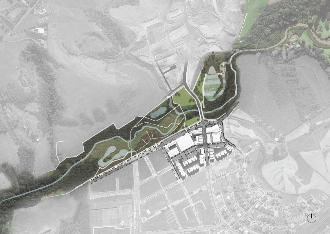
The scope includes the design of three wetland areas forming part of an integrated low-impact design network and stormwater treatment system for the wider development, a road bridge on the site’s main north-south spine connecting the two sides of the stream, and a series of secondary pedestrian bridges providing pedestrian connectivity between the stream corridor, the neighborhood and adjacent Long Bay Regional Park.
The Vaughan’s Stream Reserve is a new 20 ha infrastructural park that will provide Long Bay’s signature landscape experience. The design strategy stitches together the ecological restoration of an existing stream corridor with new stormwater and social infrastructure programs into a contemporary coastal parkland network. The organizational strategy introduces a family of design elements – boardwalks, bridges and pavilions – which facilitate circulation, navigation and occupation.
The Corridor
The overall strategy for the corridor has been informed by the site’s history and pattern of occupation, which include: use as a seasonal camping ground providing access to the Waitematā (kai moana) and fertile land of the North Shore, Kauri Gum extraction, WW2 defenses, and intensive agriculture and farming.
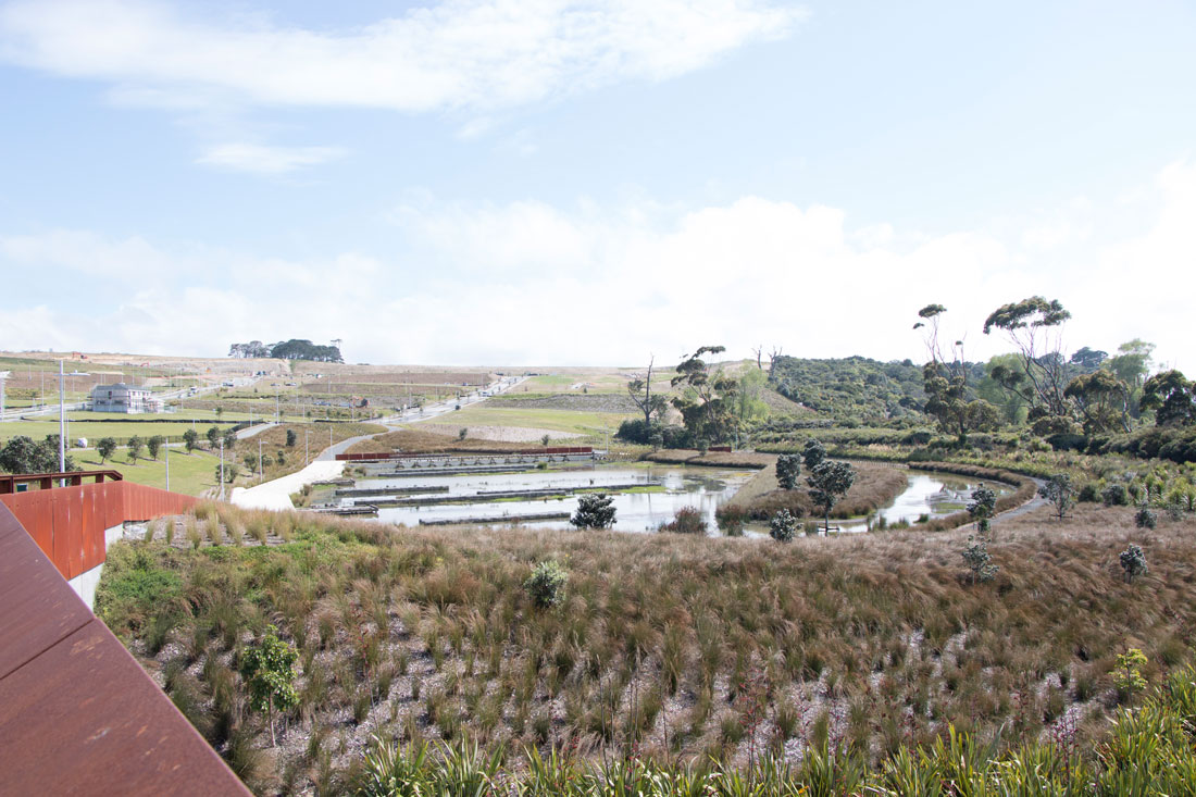
The Wetlands
The wetlands are composed of three sections: A, B and C. Currently the easternmost wetland C has been completed. A and B are to be completed by 2021.
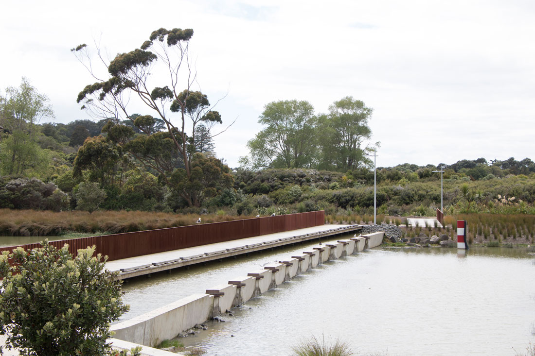
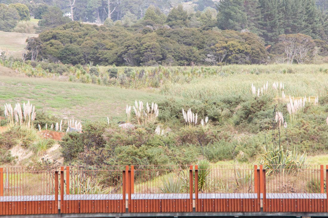
The orientation was organized north-south to provide the necessary dimensions to support the pond’s treatment chain and enable a discharge point integrated into the adjacent stream corridor appropriately. The forebay and main body of the wetland is separated with a weir that incorporates a pedestrian access bridge leading to the Long Bay Regional Park walkway. The pond is therefore able to be experienced by local residents from the surrounding village.
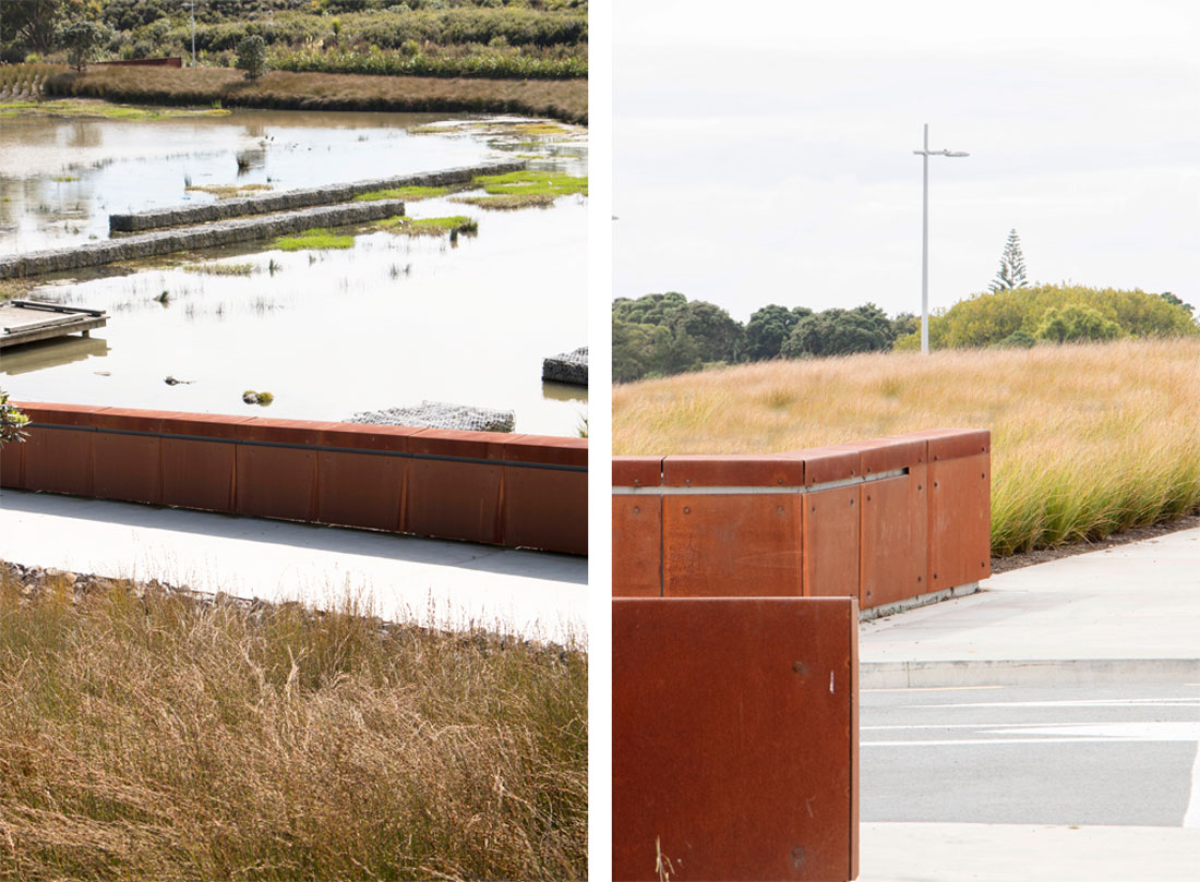
The Corten weirs assist with water aeration, introduce the sound of water as an experience and manage water flow in a variety of events.
A pedestrian path runs along the western side of the pond linking the park spaces to the adjacent Long Bay Village via a road bridge. Opportunities to access the water’s edge are provided via timber decks that are also oriented to offer wider landscape views.
Horizontal rows of gabions within the body of the pond define alternating pond depths that support surface flow (SF) and sub-surface flows (SSF) and water circulation. These are integrated with planting. Planting integrates the pond and adjacent stream corridor.
The Bridge
The Vaughan’s Stream Bridge reconceives conventional notions of a bridge to propose an infrastructural and landscape-led approach characterized by its horizontality, which meshes with the surrounding landscape and preserves views to the wider coastal landscape. The design strategy harnesses the convergence of the site’s wider movement networks to create a landmark and focal point sensitive to its riparian and coastal context.
The key design driver was a bridge as landscape. This was enabled by considering the bridge as:
– a unifying, connecting and horizontal sculptural form within the coastal valley landscape
– subservient to the wider landscape, harbor and island views
– gathering together park and village circulation to reinforce the plaza as the geographical center of the village
– providing a focal point for movement, circulation, community and the viewing platform within the stream corridor
– part of a ‘family’ of bridge elements, which includes the wetland boardwalks/bridges.
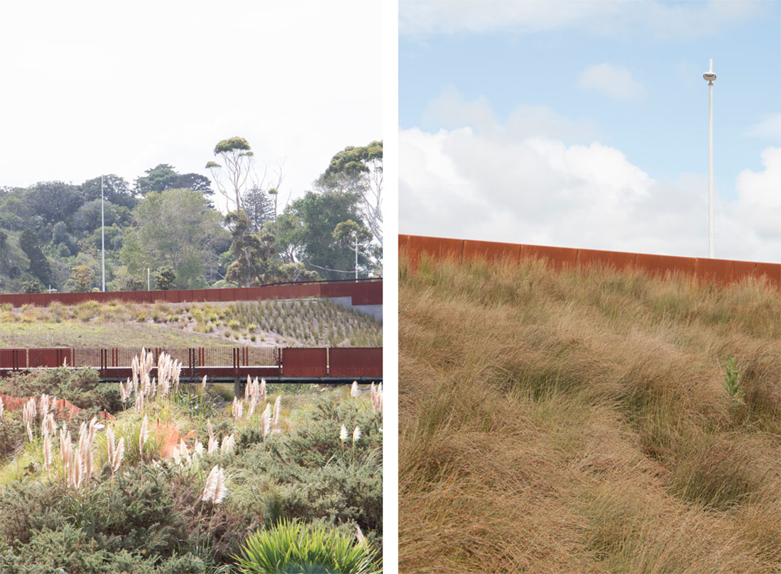
The bridge form extends a folded sequence of Corten clad walls across the stream corridor and integrated into the surrounding landscape to inform path connections and approaches. This supports legibility and wayfinding and extends the bridge beyond its span into the surrounding landscape to define retaining and safe edges adjacent other parts of the stream corridor.
The Corten paneling incorporates feature lighting and a Matariki perforated pattern that recalls navigation and wayfinding to and from the site by sea.
Pedestrian Bridge
The design of the smaller bridges and balustrades seeks to reinforce wayfinding through the use of solid panels that unfold and extend into the landscape. These reinforce legibility and define access. This contrasts with lighter detailing over water, which enables views of the stream corridor and water from the bridge and surrounding spaces.
These bridges continue the materiality of the wider project – concrete, timber and Corten steel – and the detailing of balustrades via a sculptural composition of solid panels and vertical bars.
Like the larger road bridge, the balustrades extend into the adjacent landscape and define approaches for people to occupy and meet.
Social Interaction
The network of paths and spaces creates new places to gather around, adjacent and over the stream corridor.
An open lawn terrace above the wetland provides an amphitheater type space for gathering and views across the wetland to Long Bay Reserve beyond.
The network of paths and bridge connections is designed to ensure legibility and interaction for circulation.
Integrated seating provides for a range of social seating opportunities.
Amenity
A key aspiration of the design was to allow access to and around the wetland rather than fencing it off. This enables engagement with and a greater understanding of the journey of water through the site.
Accessibility
New walking and cycling connections are provided across the wider site by the new network of paths and bridges. In particular, access is enabled between the site and Long Bay Regional Park. Integration of this pathway has been curated to take people across the corridor, wetland and alongside the existing Vaughan’s Stream corridor. This journey manages significant level changes and provides a sense of journey and transition from the beach to Long Bay Village.
Safety
Improved safety and lighting provided by amenity and area lighting. The Long Bay Bridge incorporates internal feature lighting through a perforated pattern in the Corten paneling, which recalls navigation and wayfinding in reference to the site’s historical seasonal occupation for fishing journeys into the Waitemata.
Cultural Resonance
The design process was established through the Local Board, Te Kawerau ā Maki and Ngāti Whātua who have provided design review into the process throughout. Key themes integrated into the design include enhancing water quality, ecological habitat and the themes of navigation and wayfinding. The folded forms of the bridge and balustrades reflect forms of both vessels and former industrial infrastructure associated with the Kauri gum extraction on the site.
Closing Statement
The design approach has transformed what could have been a utilitarian stormwater treatment corridor into an integrated infrastructural, open space network. The project has established the corridor as a focal point of the wider Long Bay redevelopment and contributed to the appeal, amenity and value of the site. Its sensitivity to the surrounding significant landscape of Long Bay and the Waitematā beyond has ensured an appropriate fit and transition between the surrounding project and these important existing natural landscapes.
“Long Bay represents one of New Zealand’s few examples where land use planning and catchment management planning have been developed simultaneously.” – Auckland Design Manual
The attention to detail in the design of bridges, boardwalks and wetland infrastructure ensures the spaces are understood as more than just successfully weaving in layers of opportunity for access, movement, viewing, recreation and discovery. The project demonstrates the importance of integrated and design-led outcomes that merge infrastructure, open space, landscape and ecology.
The project has provided:
– a park which provides the ‘social catalyst’ for the redevelopment and reoccupation of the Long Bay project by enabling social infrastructure, gathering and events
– an ‘ecological agent’ which enables a low-impact (LID) and water sensitive (WSUD) design approach that enhances the existing stream valley ecosystem
– an ‘infrastructure’ which informs movement, enhances connectivity and processes and treats stormwater
– an ‘imaginative enterprise’ which provides the opportunity to reinforce identity and support the creation of a new community
– an embedded robustness, flexibility and resilience that will enable the network of spaces to adapt and evolve over time
– a reinforcement of Long Bay Communities Ltd (Todd Properties) aspirations re: sustainability, innovation and design excellence