https://urbannext.net/risks-of-informal-settlements/
| Risks of Informal Settlements in Argentina: Forms of Vulnerability in the Face of a Transforming Climate https://urbannext.net/risks-of-informal-settlements/ |
Categories: Contributors, Data, Densities, Felipe Vera, Formats, Inter-American Development Bank, Jeannette Sordi, No Density, Politics and economics, Southern Coexistences, Territory and mobility, Topics
The first country for which we have developed the Risk Atlas of Informal Settlements is Argentina, where recently there have been nationwide surveys on the conditions of communities living in informal situations. In 2016, the government of Argentina promoted surveys of precarious housing and settlements, by establishing a National Register of Informal Settlements also known as ReNaBaP (Registro Nacional de Barrios Populares), the first official survey that mapped and characterized informal settlements in the country. This allows us to have a clear idea of the amount of people living in situations of extreme vulnerability. In accordance with the adopted definition, an informal settlement, barrio popular, is that which unites at least eight grouped or adjacent families, half of whom do not have legal land rights, nor do they have regular access to at least two basic services (running water networks, electric energy networks with a home measuring system, and a sewage system).
Argentina is aligned with Latin America in the percentage increase of urban population between 1990 and 2014. The residential community of informal settlements continued to increase in Argentina until around the year 2000, when it began to descend. However, over 1 in every 6 inhabitants in Argentina and 1 every 5 inhabitants in Latin America and the Caribbean still lives in informal settlements. More than 100,000 new families have been registered as residents of informal settlements each decade (132,526 new families in 2000, 197,591 in 2010, 104,589 in 2018). This proves how the phenomenon is constantly evolving. In 2018, the ReNaBaP identified that in 4,416 settlements (where approximately 935,000 families live), around 4,000,000 inhabitants live in vulnerable conditions. The majority of informal settlements and families are found in Buenos Aires with 484,045 families living in 1,726 neighborhoods. In Argentina, 55% of informal neighborhoods are registered and have been settled before the year 2000, while 26% appeared throughout 2000-2010, and 19% between 2010 and 2016. Most often, these urbanizations have been developed in marginal areas, on residual contaminated lands that are exposed to flooding and heat waves, which have intensified in recent years as a consequence of climate change. It is estimated that 93.81% of homes do not have access to formal running-water systems, while 98.81% don’t have access to formal sewage systems, and 70.69% to formal electricity. At the same time, a lack of public spaces and recreational areas has been registered, which makes social cohesion more difficult and limits development. Approximately 45% of informal settlements are found in zones that are subject to some type of environmental risk. This trend of territorial occupation increases pressure on factors that worsen the effects of flooding and population vulnerability. Additionally, basic services in these neighborhoods have higher exposure, risk, and vulnerability to storm and heat waves, among other phenomena.
The data that is developed from a sample of studied territories, which includes Alto Valle de Rio Negro, AMR, Buenos Aires, CABA, Córdoba, Gran Corrientes, Gran Resistencia, San Miguel de Tucuman, Misiones, Neuquén, and Salta. A high percentage of the settlements, around 70%, have no sewage systems, sidewalks, or paved roads. This influences risks of flooding (almost 65%) and sustainable mobility. There is a lack of waste collection by municipalities and waste elimination by burning, almost 40%, which impacts environmental contamination, especially in the case of flooding. Other methods of reported waste collection include throwing garbage outside the neighborhood, into open-air bins and riverbanks or streams, which is damaging for health and the environment. Almost 84% of informal settlements in Argentina lack public sewage systems. All these factors influence the health and well-being of communities, which is key for their socioeconomic resilience in the case of extreme climate events.
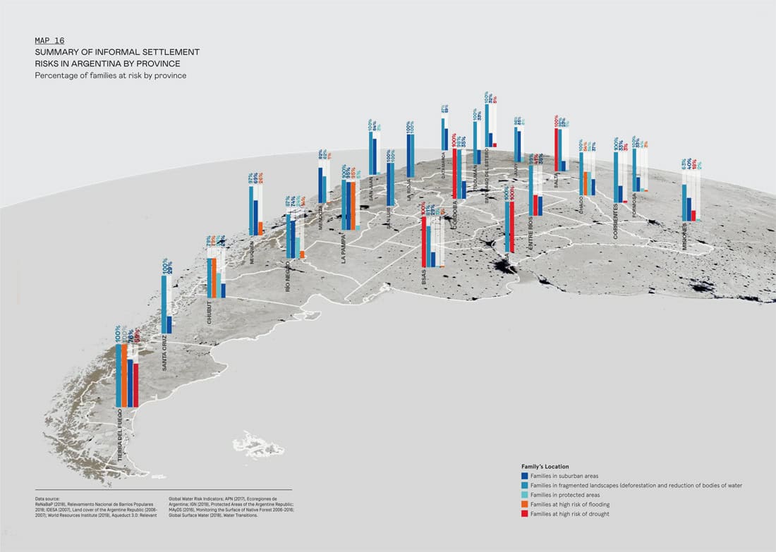
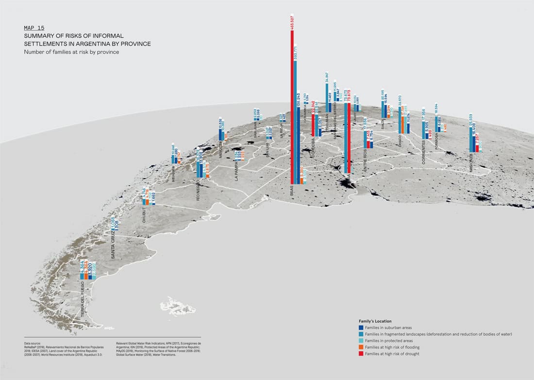
Map 15 shows the number of families from informal settlements that are exposed to the main elements of vulnerability, analyzed in the Risk Atlas. These include families that live in suburban areas; families in fragmented landscapes, affected by deforestation and lost bodies of water; families in protected areas; families who live in high-risk areas for flooding or drought. The vulnerabilities of each province on a national scale are shown, in order to define priorities and action strategies for green infrastructure, and to evaluate which are the highest risks. Vulnerability to droughts is an important priority for the families located in the province of Buenos Aires (also known as Autonomous City of Buenos Aires, or CABA), and Santa Fe. Landscape fragmentation, evaluated in terms of percentage of land that is subject to deforestation and water loss, also affects a significant number of families in several regions, being the priority risk in Tucuman, Misiones, Salta, Formosa, Entre Rios, or Corrientes. Settlements in protected areas are an important condition in Chaco, as is flooding. Map 16 shows the percentage of low-income neighborhoods according to risk in each province. This is useful for understanding which risks are most prevalent in each province, so that strategies of action in green infrastructure can be focused. For example, in CABA, Buenos Aires, Cordoba, and Santa De, 100% of families are exposed to a high risk of drought. In Chaco, CABA, Corrientes, Formosa, La Pampa, La Rioja, Salta, San Juan, San Luis, Santa Cruz, Santiago del Estero, Tierra del Fuego, and Tucuman, 100% are in fragmented landscapes for deforestation and/or loss of water. In La Pampa and Tierra del Fuego, almost 100% of families are at high risk of flooding. In Chaco and Tierra del Fuego, around 55% of families are found in protected areas. In La Rioja and San Luis, 100% of families are in suburban areas.
In the first instance, the Risk Atlas for Argentina is focused on exploring ecological territorial vulnerability and will later be expanded to the other dimensions of vulnerability. The Atlas works in a multidimensional manner, in order to arrive at a neighborhood scale in the city of Corrientes. To construct the Atlas, climate-change data from different sources is matched with information on informal settlements gathered by the National Register of Informal Settlements. The ReNaBaP collects and details information on slums and precarious settlements in Argentina and is published on the TECHO Argentina web page. Information from the Aqueduct page is also used in the hydrologic Risk Atlas from the World Resources Institute, with respect to climate change and the effects it produces, including flooding and droughts. For the maps related to types of land use, available information from the IDESA web page is used (Land Coverage of the Republic of Argentina), IGNA (Protected Areas), APN (Argentinian Ecoregions), SAYDS (Monitoring the Surface of Native Forest) and Global Surface Water (Lost permanent water transition). This combined information recognizes previously realized efforts, such as the case of the System of Climate Change Risk Maps of the Environment and Sustainable Development Secretary, from the government of Argentina. Starting from this, the Atlas intends to explore the effects and impacts of climate change in informal settlements in particular.
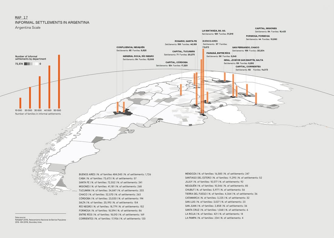
The preliminary results of the Atlas, organized by type of risk, are summarized here. As Map 17 shows, a high density of the population is exposed to climate risks that are accentuated by the precarious and vulnerable conditions of informal settlements. The map shows neighborhood density by department. Departments with the highest number of informal settlements are highlighted in dark gray, and the number of corresponding families are shown in red bars, from smallest to largest height and width, according to the quantity. The highest number is found in the CABA and the departments of Rosario (region of Santa Fe) and Tucuman. The map is accompanied by a summarized list of data for every province.
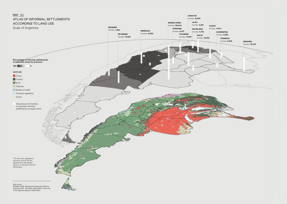
In relation to land use, Map 21 analyzes important environmental risks. For example, intense cultivation can provoke land erosion and increase the risk of floods. Its transformation over time impacts the exposure of informal settlements to climatic, temporary, and permanent crises. The highest percentages of informal settlements in suburban areas are in the regions of Cuyo, Sierras Pampeana, and Noroeste, and also in the south of Patagonia. In these regions, there is a prevalence of forest and bush land use. However, at the national scale, the majority of informal settlements are situated on cultivated land.
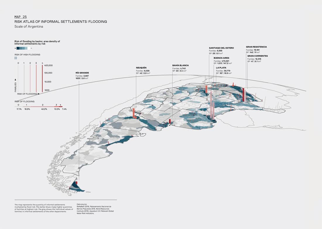
With respect to hydrological risks, the Atlas evaluated risks of floods and droughts. To the right of Map 25, we can see 483,000 families, and in CABA, Cordoba, and Santa Fe, almost 100% of informal settlements have been identified as vulnerable to risk of droughts. In Tierra del Fuego and La Pampa, essentially 100% are at risk of high floods. The plains in the east of Santa Fe are almost exclusively occupied by informal neighborhoods, precarious housing, and other modalities of vulnerable settlements. In this zone, the high risk of floods has reduced their market value, and only those who cannot afford a formal settlement settle there. Surveys also highlighted the presence of settlements inhabited by immigrants from Bolivia and Paraguay at the edges of the contaminated Reconquista River and Matanza River in Buenos Aires. They suffer the stench of still water and untreated residual waters, rat invasions, mosquitoes, flies, and other insects, in wastelands that are difficult to develop. These are not isolated risks. There are cases of informal settlements in Buenos Aires built on an old lakebed, a toxic wasteland, a cemetery, and a flood plain.
Flood risks are represented in Map 25. The map shows flood risks of basins in blue tones, according to the area density of informal settlements, in order to establish priorities of action. The dotted shade shows the risk of high floods. Almost 50% of informal settlements (graph below, right) is found in category 2 (mid-to-high risk) and almost 20% in 304 high-very high), according to the data from Aqueduct. This increases floods, due to a lack in drainage infrastructure. Cities with higher risk are highlighted, according to their area of informal settlements and flood risk. The highest average of flood risk is found in Tierra del Fuego, with 100% of families at very high risk. In second place, La Pampa has a high average risk of 3.54, and 95% of families at very high risk. In third place, Chaco and Chubut have a high average risk of over 3, and almost 54% and 79% of families are at very high risk.
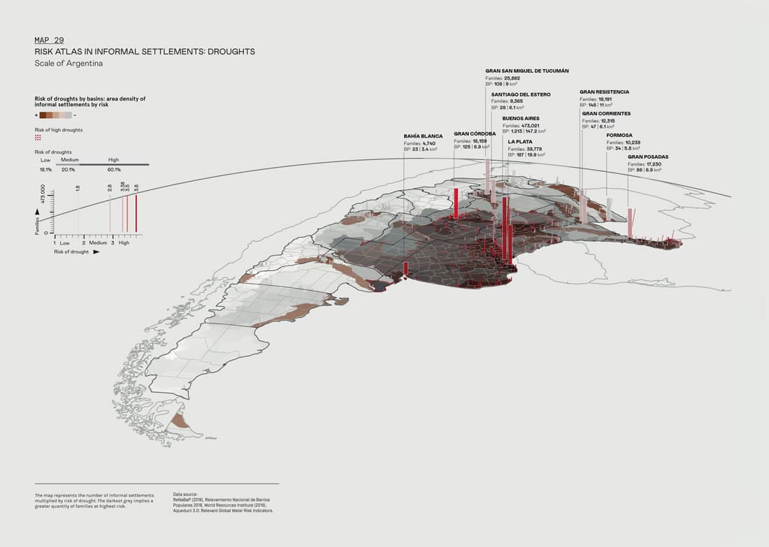
Map 29 shows the risk of drought (a significant condition with respect to climate change) and water supply infrastructure in informal settlements. In urban surroundings, it can increase greenhouse and albedo effects. The base of the map shows the risk of drought per basin and per area. In Buenos Aires, 483,000 families in CABA, CórdobSanta Fe, corresponding to almost 100% of informal settlements, are identified as vulnerable to risk of drought. In Tierra del Fuego and La Pampa, virtually 100% are at high risk of flooding. In the summary of data found in the introduction to the Atlas, Graph 15 shows the elevated number of families in high risk of drought. Here, the average risk per family and province is seen (left), where Buenos Aires and CABA have higher averages. In Buenos Aires, CABA, Córdoba, and Santa Fe, 99 to 100% of families are at high risk of drought.
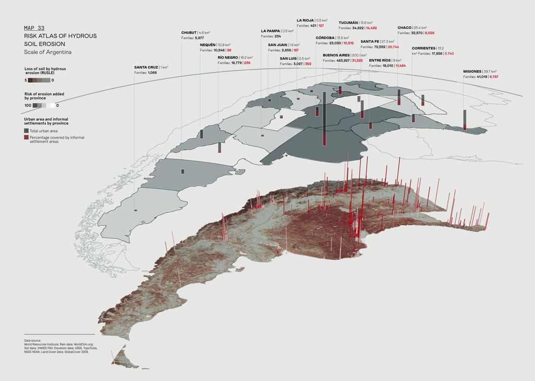
Hydrous erosion is analyzed in Map 33. To evaluate the risk of hydrous erosion of the land, the Revised Universal Soil Loss Equation (RUSLE) was used, which predicts the annual loss of land from rain and water runoff. This is the most common model, used by large scale spaces due to its relatively simple structure and empirical basis. The model takes into account: (1) rain erosion, (2) climate classification, (3) soil data, (4) elevation data, and (5) soil cover data. It is important to highlight, with respect to land in the informal settlements, that land contamination has not been evaluated, due to lack of data availability. Many informal settlements are situated in areas that are contaminated by garbage dumps or industrial waste with no treatment. Risk of illness is high and is multiplied by conditions of climate change such as flooding, drought, or land erosion. These maps show erosion according to the RUSLE average per province (above) and the territory in their different degrees (below). The most affected provinces are Buenos Aires (over 31,000 families), Córdoba, Santa Fe (almost 27,000 families), and Tucuman. The black bars show the total number of families, and the red shows the total number of families affected by the highest levels of erosion. 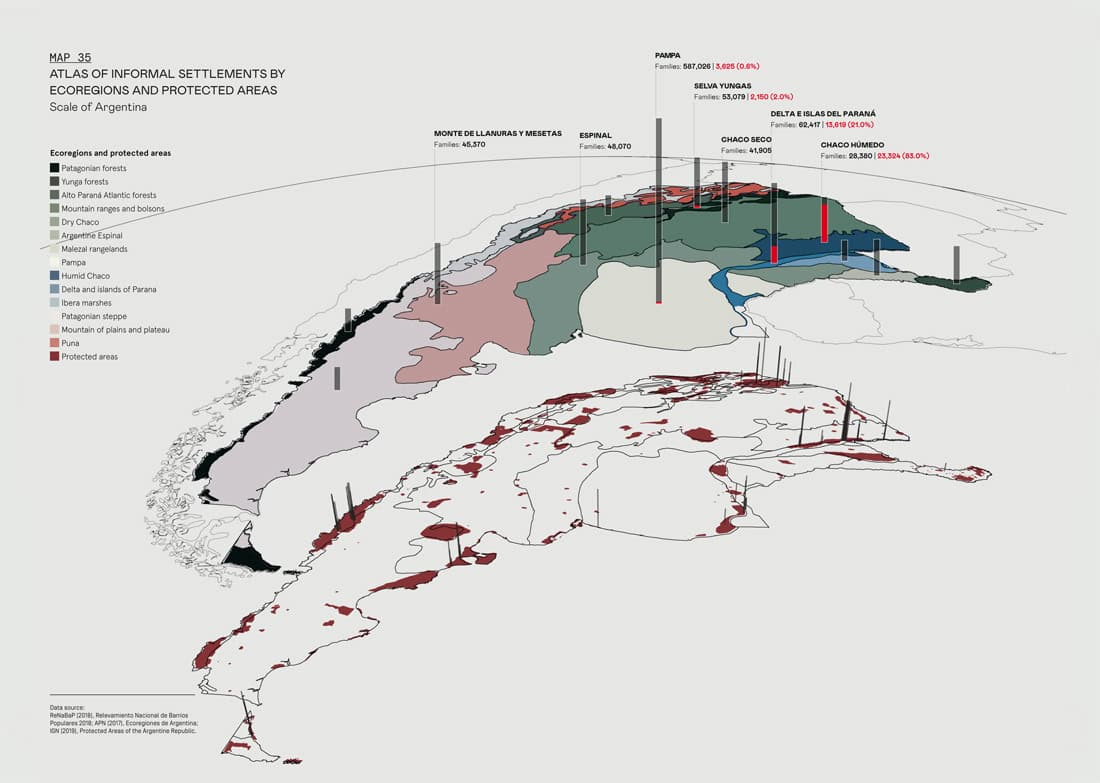
Thinking of possible strategies of mitigation based on nature, the Atlas also incorporates the analysis of ecoregions, which can be seen in Map 35. Visualizing the dynamics of ecosystems in which informal settlements are located is very useful for designing strategies of green infrastructure. It is also useful for understanding the risks and the functionality of each landscape (water retention and runoff, types of soil, vegetation, etc.) and forms of landscape protection and conservation. This map shows a classification of countries by ecoregions (above) and protected zones (below). In the upper layer of the graph, the number and percentage of families settled in protected zones is shown in red. The map below represents, with vertical bars, the position of the settlements in protected zones, whose height is proportional to the number of families. The highest number of families with risks posed by the informal settlements locations in protected areas, can be found in Chaco. Almost 18,000, over 50% of the families in this province, can be found in protected areas. Tierra del Fuego (almost 60%, 2,592 families), Chubut (almost 30%), and Rio Negro (24%, 4,514 families) are the provinces with highest percentages.
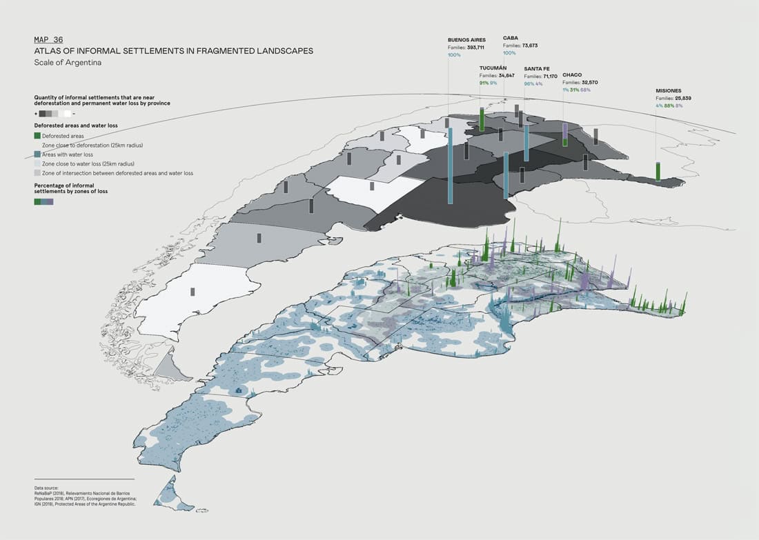
Lastly, the Atlas explores the level of fragmentation in landscapes where informal settlements are settled. This is seen in Map 36. The protection of natural landscapes increases the resilience of urban surroundings. Deforestation and loss of bodies of water carries with it fragmentation of landscapes, loss of biodiversity, reduction of ecosystem services like carbon absorption, and increases in hydrous fragility. The lower map represents informal settlements that are found in a radius of 25km of deforested areas (in green), water loss (blue), or both (purple). In the map above, metric calculations are shown in percentages of neighborhoods affected in the most affected province. Buenos Aires is highlighted for its number of families and, in second place, Santa Fe and CABA. In the cases of Buenos Aires, Chubut, CABA, La Pampa, Mendoza, Neuquén, Rio Negro, San Juan, Santa Cruz, Santa Fe, and Tierra del Fiego, 100% of the surveyed families reside in areas of water loss, and many of them coincide with risk of drought. In Catamarca and La Rioja, 100% of fragmented landscape zones, where families of informal settlements live, are in zones of deforestation, which increases the vulnerability of territories to droughts and extreme climate events. In Santiago del Estero, Formosa, and Corrientes, there is a high percentage of mutual overlapping. The risks of landscape fragmentation are associated with the loss of resilience to drought and extreme climate events, caused either by deforestation or a decrease in bodies of water, or the invasion of unsinkable basins. Deforestation is an unnatural risk that contributes to land erosion and to vulnerability to floods, as the vegetation slows down erosion and increases soil filtration, preventing its erosion. Additionally, there is a loss of carbon sinks, causing the disappearance of entire ecosystems that contribute to biodiversity. The loss of bodies of water can also increase these phenomena, as can droughts, with risks to health and social well-being. The Atlas shows informal settlements in these zones or their surroundings. This is one of the larger risks that affect informal settlements, as in the majority of the provinces, almost 100% of informal settlements are found in fragmented landscapes. In the case of Catamarca and La Rioja, 100% are close to zones of deforestation. In Buenos Aires, CABA, Mendoza, Chubut, Neuquén, Rio Negro, and other provinces, 100% are located near zones where bodies of water are disappearing. Santiago del Estero and Corrientes are highlighted for their proximity to both types of zones.
The invasion of natural reserves, protected basins, and green belts is another of the risks associated with fragmentation. The invasion of these zones causes a loss of continuity and therefore a loss of ecosystem services or benefits and the functions they provide: greenhouse gas absorption, protection from floods, air quality, soil protection, etc. Although this persists while urban plans and building are being developed, the risks for the inhabitants of informal settlements that are already in vulnerable situations are worsened. In the province of Chaco, over 17,000 families are found in protected landscapes, and over 5,000 in Buenos Aires. In Tierra del Fuego, over 60% of informal settlements are settled in natural reserves. In order to design a resilient infrastructure from natural principles, it is important to know the landscapes and natural dynamics of what is inserted (vegetation, types of soil, hydraulic systems, etc.) The Atlas includes a map of the natural landscapes in Argentina in order to situate informal settlements in their natural context, restore a connection with the territory, and generate landscape resilience.
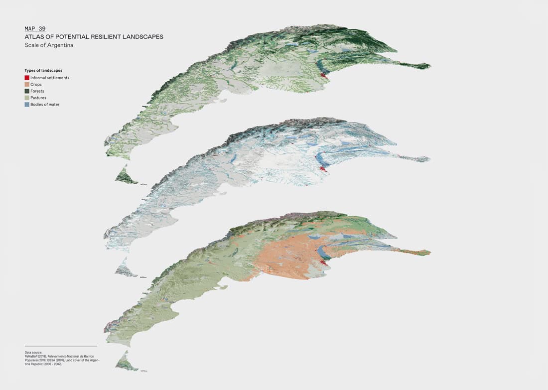
This series of maps, compiled in Map 39, shows the potential sequence of landscape recuperation in Argentina, starting on a national scale. The fragmentation of existing landscapes can diminish if it interconnects through the national network of rivers and bodies of water, so that it can foster ecological corridors that permit Argentinian landscapes to expand and recuperate.
Local landscapes such as forests, marshes, pastures, etc., generate benefits, such as an increase in storage capacity, filtration, and water recycling; an increase in biodiversity and ecological wealth; soil recovery and carbon storage in soil and vegetal species, among others. The expansion of resilient local landscapes benefits low-income neighborhoods, if green infrastructure that is implemented in them is connected or is directly linked to these ecological corridors. The interconnection between the low-income neighborhoods and resilient landscapes assures that the neighborhoods can get access to ecological benefits that involve the landscapes. They can also guarantee the mitigation of extreme events such as floods or heat-island effects in the short, medium, and long term.
| ISSN : 2575-5374 |